

It has been very windy today along the Rocky Mountain Front and out to I-15 as well as in Cascade County and Judith Basin County.

Peak wind gusts were between 50 and 80 mph in a lot of locations, and a few locations along the immediate eastern slopes of the Rocky Mountain Front recorded wind gusts over 100 mph!

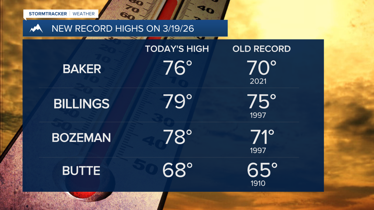
It was also unseasonably warm today as highs were in the 60s and 70s, and a lot of locations tied or set a new record high temperature today. A fitting end to what has been a warm winter.


The wind will diminish some this evening and tonight, but it will continue to be windy tonight along the Rocky Mountain Front as gusts over 70 mph are possible, and it will be gusty tonight east of the Rocky Mountain Front as sustained wind speeds are going to be between 10 and 30 mph, and gusts over 40 mph are possible.
Here is the detailed forecast:
A HIGH WIND WARNING remains in effect for the Rocky Mountain Front and the Cut Bank area until 12pm tonight. It is also going to be partly to mostly cloudy and mild tonight as lows are going to be in the 40s and low to mid 50s in most locations.
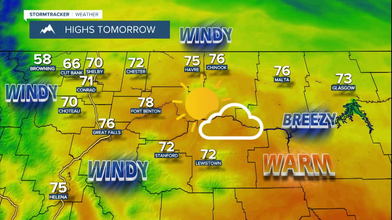
It will continue to be very windy along the Rocky Mountain Front/the Divide and in the Cut Bank area tomorrow as sustained wind speeds are going to be between 30 and 50 mph, and wind gusts up to 85 mph are possible. It is also going to be windy tomorrow east of the Rocky Mountain Front as sustained wind speeds are going to be between 15 and 35 mph, and wind gusts will be between 40 and 65 mph.
A HIGH WIND WARNING is in effect for the Rocky Mountain Front/the Divide, the Cut Bank area, the higher terrain in central Montana, and Cascade, Fergus, and Judith Basin counties from 6am/9am tomorrow until 12pm Saturday.

In northeastern Montana and in the Helena Valley, it will be breezy/gusty tomorrow as sustained wind speeds are going to be between 10 and 25 mph, and wind gusts over 40 mph are possible.
Tomorrow is the first day of Spring as Spring officially begins at 8:46am MDT, but it will feel more like early summer as highs are going to be in the 70s and upper 60s. Multiple locations will likely set a new record high temperature again tomorrow. Around Helena, it is going to be mostly sunny and dry tomorrow, while in north-central Montana, it is going to be partly to mostly cloudy and mostly dry tomorrow, just a few isolated rain showers around.

A cold front will cool our temperatures back down for the weekend as highs are going to be back in the 50s and upper 40s. There are going to be some scattered lower elevation rain and mountain snow showers around on Saturday, especially during the afternoon and evening, as the cold front passes through. It is also going to be partly to mostly cloudy on Saturday.
Sunday will be mostly sunny and mostly dry, just a few isolated rain and snow showers along the eastern half of the Hi-Line during the morning. Saturday will be a breezy day as sustained wind speeds are going to be between 10 and 25 mph, and wind gusts over 40 mph are possible. There is then just going to be a bit of a breeze around on Sunday as sustained wind speeds are going to be between 10 and 20 mph.

Monday will be a cloudy, dry, and cool day as highs are going to be in the 50s. It is also going to be a bit breezy in some areas on Monday as sustained wind speeds are going to be between 10 and 20 mph.
There are going to be a few rain and snow showers around Tuesday through Thursday, generally in the mountains and along the Hi-Line, as a few disturbances pass through our area. Tuesday will be mostly cloudy; Wednesday will be partly cloudy; and Thursday will be mostly sunny.
Widespread gusty to strong winds are also expected from Tuesday through Thursday as sustained wind speeds are going to be between 10 and 30 mph, and wind gusts over 50 mph are possible. It will be mild on Tuesday and Wednesday as highs are going to be in the mid to upper 50s and low 60s. The temperatures will then cool down some for Thursday as highs are going to be back in the 40s.

