


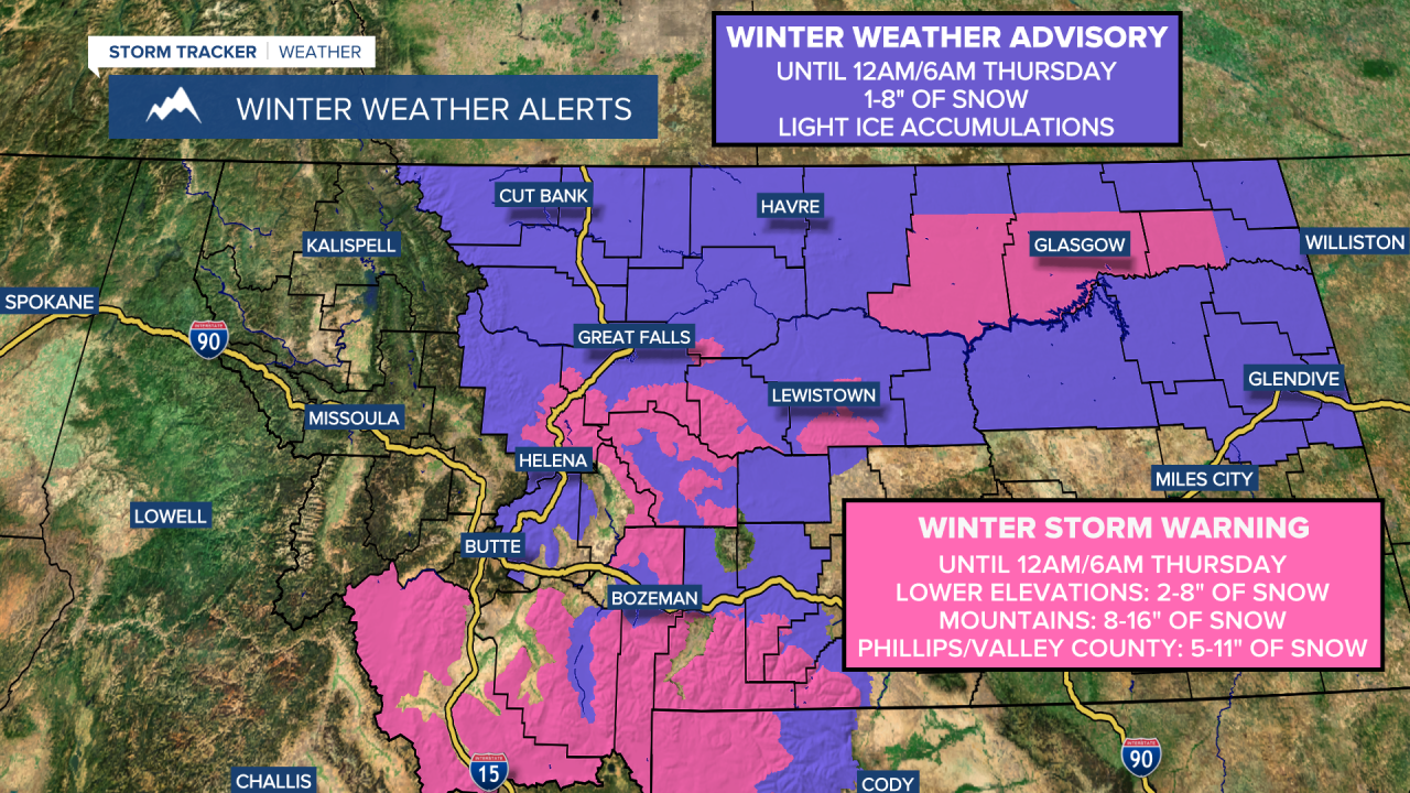
A WINTER STORM WARNING is in effect until 12am/6am Thursday for portions of southwestern and central Montana as well as central/southern Phillips County and central/southern Valley County. In the lower elevations, 2 to 8 inches of snow accumulation is expected. In the mountains, 8 to 16 inches of snow accumulation is expected. In central/southern Phillips County and central/southern Valley County, 5 to 11 inches of snow accumulation is expected.
A WINTER WEATHER ADVISORY is in effect for a lot of central and north-central Montana until 12am/6am Thursday. 1 to 8 inches of snow accumulation is expected. Light ice accumulations are also possible.
Precipitation is going to become widespread within central and north-central Montana as we go through tonight. Some rain, freezing rain, and sleet is also possible in central Montana early on, but this wintry mix will switch-over to all snow as the night goes on. In north-central Montana, mainly snow is expected tonight.
We are then going to have widespread snow around tomorrow, with the snow gradually becoming lighter and more showery in nature as we head into tomorrow afternoon and evening. There are then going to be scattered snow showers around tomorrow night, especially before midnight and especially in locations east of I-15. Also, the snow that falls tonight and tomorrow morning may be heavy at times.
Between this evening and midday Thursday, 1 to 8 inches of snow accumulation is expected in the lower elevations, and 6 to 16+ inches of snow accumulation is expected in the mountains. Slick/snow-covered roads and areas of low visibility are also expected, so please be careful when driving. This snow is also going to impact the Wednesday morning and evening commutes, so make sure you give yourself some extra time to get to where you need to go.

It is also going to be chilly tonight and tomorrow as lows tonight are going to range from the upper teens to the low 30s, and highs tomorrow are going to be in the mid to upper 20s and low to mid 30s in most locations. For tonight, there is going to be a breeze around in some locations as sustained wind speeds are going to be between 10 and 25 mph. Breezy conditions are then expected tomorrow along/just east of the Continental Divide and in some of the mountains in central Montana as sustained wind speeds are going to be between 10 and 25 mph.
On Thursday, we are going to have decreasing clouds with some isolated snow showers around, generally during the morning and generally in locations east of I-15. It is also going to be chilly on Thursday as highs are going to be in the 30s and upper 20s in most locations.
Pleasant weather is then expected for St. Patrick’s Day (Friday) and this weekend as high pressure is going to be in control of our weather. On Friday and Saturday, we are going to have mostly to mainly sunny skies and dry conditions. We are then going to have partly cloudy to mostly sunny skies and mostly dry conditions on Sunday. We are also going to have little wind around on these three days. Cool/below-average temperatures are also expected on these three days as highs are going to be in the 20s, 30s, and low 40s in most locations, with the coldest temperatures along the Hi-Line.
On Monday, we are going to have partly cloudy to mostly sunny skies and mostly dry conditions. We are then going to have mostly cloudy skies on Tuesday with a chance of rain and snow showers as a storm system begins to approach our area. It is also going to continue to be cool on these two days as highs are going to range from the low 20s to the mid 40s, with the coldest temperatures along the Hi-Line.


