A WIND CHILL WARNING is in effect for most of central and north-central Montana until 12pm Friday. Wind chills as low as 40 to 55 below zero are possible.
A WIND CHILL ADVISORY is in effect for portions of north-central Montana from 12pm Friday until 12pm Saturday and for southwestern Montana until 5am/12pm Friday. A WIND CHILL ADVISORY is also in effect for northeastern Montana until 9am/12pm Saturday. Wind chills as low as 35 below zero are possible.

A WINTER STORM WARNING is in effect for the Rocky Mountain Front from 9am Friday until 5pm Saturday. Significant blowing and drifting snow is expected as winds are going to be gusting as high as 70 mph.

We are going to have mostly to partly cloudy skies tonight with some isolated snow showers around. It is also going to be very cold tonight as lows are going to be in the -10s and -20s in a lot of locations, and wind chills are going to be in the -30s and -40s in a lot of locations.
For tomorrow, we are going to have decreasing clouds with a couple isolated snow showers around during the morning. We are also going to have a wide range of temperatures tomorrow as a warm front slowly works its way northward. Along the Hi-Line, highs tomorrow are going to be in the -0s and 0s. South of the Hi-Line, highs tomorrow are going to be in the 0s and 10s. Wind chills are also going to improve as we go through tomorrow, but they are still going to be below zero for a lot of the day.
We are also going to have increasing wind tomorrow along the Rocky Mountain Front and in some of the mountains in central Montana. We are then going to have increasing wind tomorrow night in some locations east of the Rocky Mountain Front. This wind is also going to cause there to be areas of blowing and drifting snow, especially along the Rocky Mountain Front.
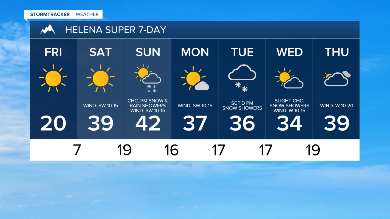
The temperatures are then going to continue to warm up this weekend as highs are going to be in the 20s and 30s on Saturday and the 30s and low to mid 40s on Sunday. It is also going to be very windy on Saturday along the Rocky Mountain Front as wind gusts up to 70 mph are going to be possible at times. East of the Rocky Mountain Front, we are going to have gusty winds around in some areas on Saturday as wind gusts over 40 mph are going to be possible at times. We are then going to have widespread gusty winds around on Sunday as sustained wind speeds are going to be between 10 and 30 mph, and wind gusts over 40 mph are going to be possible at times. This wind is also going to cause there to be areas of blowing and drifting snow around, especially on Saturday.
We are also going to have mostly sunny skies and mainly dry conditions on Saturday. We are then going to have increasing clouds on Sunday with a chance of PM snow and rain showers, generally in the mountains and around the Helena area, as a cold front begins to pass through our area.
Partly cloudy skies and mainly dry conditions are then expected on Monday. There are then going to be some scattered snow showers around on Tuesday, generally during the afternoon and evening, as a disturbance begins to pass through our area. We are then going to have partly cloudy skies on Wednesday with some isolated snow showers around, generally in locations east of I-15, as this disturbance leaves our area.
It is also going to be chilly from Monday through Wednesday as highs are going to be in the 30s and upper 20s in most locations. Breezy conditions are also expected on Monday and Wednesday as sustained wind speeds are going to be between 10 and 20 mph, and this wind is going to be coming out of the WSW.