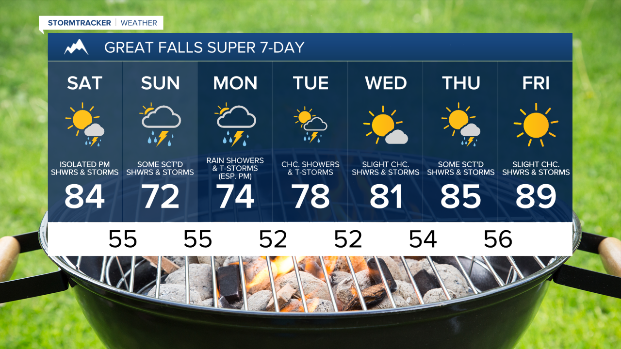
We are going to have mostly clear skies tonight with some isolated showers and thunderstorms around, especially before midnight. It is also going to feel nice outside tonight as lows are going to be in the upper 40s and low to mid 50s in most locations.
For tomorrow, we are going to have increasing clouds with a chance of PM showers and thunderstorms. There are then going to be scattered showers and thunderstorms around on Sunday as a disturbance passes through our area. Showers and thunderstorms are then likely on Independence Day (Monday), especially during the afternoon and evening, as another disturbance passes through our area. The precipitation that falls on Monday may also impact the parades and/or firework displays in some locations, so keep checking back here for more updates as we get closer. We are also going to have partly to mostly cloudy skies on Sunday and Monday.
Frequent lightning, heavy rainfall, gusty winds, and/or small to medium-sized hail are possible with all the thunderstorms that we see during the holiday weekend. A few of the thunderstorms that we see over the next three days may also be severe with 60+ mph wind gusts and/or 1+” hail. If you are going to be doing anything outdoors this weekend, make sure you stay weather aware and seek shelter if a thunderstorm is coming your way.


Tomorrow is going to be the warmest day of the holiday weekend as highs are going to be in the 80s for most of us, but there will be some 70s around along/just east of the Rocky Mountain Front. It is then going to be a lot cooler on Sunday and Monday as highs are going to be in the 60s and 70s in most locations. There is also going to be a little bit of a breeze around on both Sunday and Monday as sustained wind speeds are going to be between 5 and 20 mph.
On Tuesday, we are going to have partly cloudy skies with a few scattered showers and thunderstorms around, generally during the afternoon and evening and generally in locations east of I-15. We are then going to have mostly sunny skies on Wednesday with some isolated showers and thunderstorms around, mainly in locations east of I-15. The temperatures on these two days are also going to be near average for this time of year as highs are going to be in the mid to upper 70s and low to mid 80s in most locations. There is also going to be a little bit of a breeze around on these two days as sustained wind speeds are going to be between 5 and 20 mph.
There are then going to be some scattered showers and thunderstorms around on Thursday as a disturbance passes through our area. We are then going to have mainly sunny skies and mostly dry conditions on Friday. It is also going to be very warm on these two days as highs are going to be in the mid to upper 80s and low 90s in most locations.