We are going to have mainly clear skies and dry conditions tonight. We are also going to have diminishing wind this evening, with little to no wind tonight after the sun sets. It is also going to be cool tonight as lows are going to be in the 40s and upper 30s in most locations.
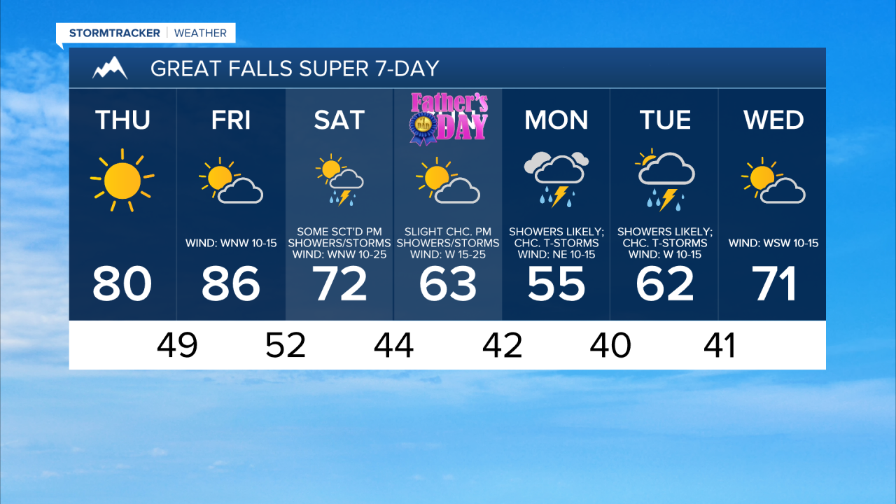
For tomorrow, we are going to have beautiful weather as we are going to have mainly sunny skies, dry conditions, little wind (sustained wind speeds between 5 and 15 mph), and pleasant temperatures as highs are going to be in the mid to upper 70s and low to mid 80 in most locations.
We are then going to have partly to mostly sunny skies with a few isolated PM showers and thunderstorms around on Friday. Friday is also going to be the warmest day of the next week as highs are going to be in the 80s in most locations. It is also going to be breezy on Friday in central Montana and in western portions of north-central Montana, especially during the afternoon and evening, as sustained wind speeds are going to be between 10 and 25 mph.
There are then going to be scattered showers and thunderstorms around on Saturday, generally during the afternoon and evening, as a disturbance passes through our area. We are also going to have partly cloudy skies on Saturday. We are then going to have increasing clouds with some isolated showers and thunderstorms around on Father’s Day (Sunday) as the next storm system begins to approach our area.
The temperatures are also going to cool down some this weekend as highs are going to be in the 60s and 70s on Saturday and highs are going to be in the 60s and mid to upper 50s on Sunday. Gusty winds are also expected this weekend as sustained wind speeds are going to be between 10 and 30 mph, and wind gusts over 40 mph are going to be possible at times.
Rain showers and a few thunderstorms are then likely on Monday and Tuesday, especially from Monday afternoon through Tuesday morning, as an upper-level trough works its way through our area. Some snow is also possible in the mountains on these two days.
Monday and Tuesday are also going to be the coolest days of the next week as highs are going to range from the mid 40s to the mid 60s. There is also going to be a bit of a breeze around on these two days as sustained wind speeds are going to be between 10 and 20 mph.
We are then going to have partly cloudy skies and mostly dry conditions on Wednesday as this upper-level trough leaves our area. It is also going to be warmer and a little breezy on Wednesday as highs are going to be in the 60s and low 70s, and sustained wind speeds are going to be between 5 and 20 mph.