


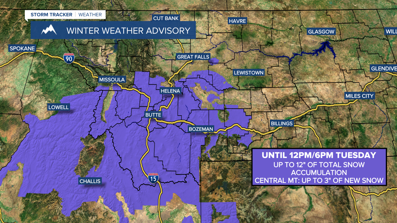
A WINTER WEATHER ADVISORY is in effect for southwestern Montana and portions of central Montana until 12pm/6pm Tuesday. Up to 12 inches of total snow accumulation is possible, with the snow amounts getting higher as you go up in elevation. In central Montana, up to 3 inches of new snow accumulation is possible between Monday evening and Tuesday evening.
There are going to be scattered areas of primarily light snow around through tomorrow morning in central Montana as a storm system passes by our area to the south. There are then going to be a few snow showers around tomorrow afternoon/evening, generally in the mountains, as this storm system leaves our area. We are also going to have overcast skies tonight and decreasing clouds tomorrow. There are also going to be some areas of fog around tonight/tomorrow morning in locations east of I-15.
The bulk of the snow accumulation with this storm system is going to be in central Montana (Great Falls, Helena, and Lewistown areas), where a coating to 4 inches of snow accumulation is expected in the lower elevations, and up to 8 inches of snow accumulation is possible in the mountains. North of Great Falls, many locations will be dry tonight and tomorrow, but some spots, like Choteau and Fort Benton, may see a little snow and may receive a coating to an inch of snow accumulation.

Slippery road conditions are also expected tonight and tomorrow morning in central Montana, so please be careful when driving and give yourself some extra time to get to where you need to go.
It is also going to be cold tonight and tomorrow as lows tonight are going to range from the single digits to the mid 20s, and highs tomorrow are going to be in the 20s and 30s. Also, for tonight and tomorrow, the coldest temperatures are going to be along the Hi-Line.
On Wednesday and Thursday, we are going to have mostly sunny skies and mostly dry conditions as high pressure is going to be in control of our weather. The temperatures are also going to warm up some over these two days as highs on Wednesday are going to be in the 20s, 30s, and low 40s, and highs on Thursday are going to be in the 30s and 40s. A few spots may even get into the low 50s on Thursday. It is also going to be breezy in some areas on Thursday as sustained wind speeds are going to be between 10 and 25 mph.
We are then going to have gusty winds around in some areas on Friday as sustained wind speeds are going to be between 10 and 30 mph, and wind gusts over 40 mph are going to be possible at times. Breezy conditions are then expected on Saturday as sustained wind speeds are going to be between 10 and 20 mph. The temperatures are also going to cool down some over these two days as highs are going to be in the mid to upper 30s and low to mid 40s on Friday, and the 30s and mid to upper 20s on Saturday. It is then going to be a touch warmer on Sunday than it is going to be on Saturday as highs are going to range from the upper 20s to the low 40s.
There are also going to be some isolated snow and rain showers around on Friday in north-central Montana, and there are going to be some scattered snow showers around on Friday around the Helena area as a disturbance passes through our area. We are then going to have a chance to see some snow showers on Saturday and Sunday, especially in north-central Montana, as a couple more disturbances pass through our area. We are also going to have partly to mostly cloudy skies on these three days.
On Monday, we are going to have partly cloudy to mostly sunny skies with some isolated snow showers around, generally in the mountains. It is also going to be chilly on Monday as highs are going to range from the upper 20s to the low 40s.


