


Happy Thanksgiving everyone! I hope you all have had a wonderful day so far! The weather during the day today really wasn’t too bad, but snow has been developing over the past few hours, generally along the Hi-Line, and this snow will continue to become more widespread in north-central Montana as we go through this evening. Around the Helena area, there are going to be some scattered rain and snow showers around this evening. Road conditions will begin to deteriorate once the sun sets, so please use extreme caution if you will be traveling anywhere this evening.
Here is the detailed forecast:
Widespread accumulating snow is likely tonight in north-central Montana, and some of the snow that falls may be moderate to heavy at times. Around the Helena area, there are going to be some scattered rain and snow showers around tonight, with widespread snow developing as we get closer to sunrise. Tomorrow will be a snowy day across the entire state. In north-central Montana and around Helena, the heaviest and most widespread snow will fall during the morning and early afternoon, with the snow breaking up some and becoming lighter during the late afternoon and evening.

Scattered snow showers will continue tomorrow night, generally in locations east of I-15, but this snow will gradually taper off from west to east as the night goes on and the skies will begin to clear out some as well.
Most of the state will see accumulating snow tonight through Saturday morning, with the highest snow amounts expected in northern and central Montana. Around the Helena area, 1-6” of snow is expected in the lower elevations, while 3-8” of snow is expected in the mountains. In north-central Montana, 4-10” of snow is expected, with isolated locations receiving up to a foot of snow. This will definitely be the biggest snowstorm that we have had since the beginning of this year.

Due to the forecasted snow, a WINTER STORM WARNING is in effect for most of north-central and northeastern Montana through tomorrow night and for portions of western Montana through tomorrow afternoon/evening. This is where the most snow is expected to fall as most will receive 3-10” of snow.

Most of the rest of Montana, including the Helena area, the Little Belts and Highwoods, the Snowies, and Judith Basin County, is under a WINTER WEATHER ADVISORY from tonight through tomorrow evening/Saturday morning. Less snow (1-5”) is expected in these locations.

Travel will be difficult throughout a lot of the state tonight through Saturday morning as roads will be snow-packed. Consider delaying travel until Saturday afternoon or Sunday if you can.
Roads will still be slick this weekend, but they will be in better shape than they will be tomorrow and Saturday morning. If you have to travel tonight, tomorrow, tomorrow night, or Saturday morning, then make sure you have a safety kit in your car, drive slowly, and give yourself plenty of time to get to where you need to go.
- Road Conditions: click here
- MDT Webcams: click here
- MTN Cameras: click here
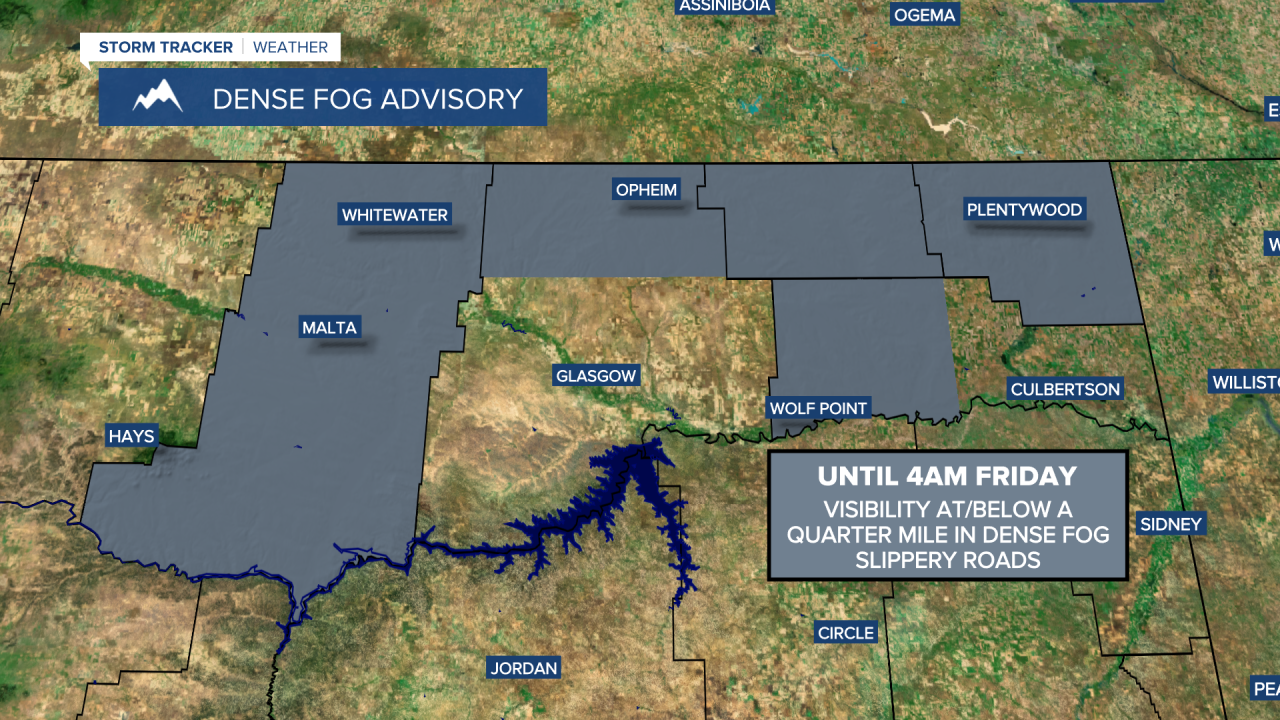
There may also be a few areas of dense freezing fog around tonight in northeastern Montana, and a DENSE FOG ADVISORY remains in effect for portions of northeastern Montana until 4am Friday.
The wind will also begin to pick up tonight behind a cold front, and it is going to be breezy in some areas later tonight and tomorrow as sustained wind speeds are going to be between 10 and 20 mph, and wind gusts over 30 mph are possible. This wind will cause there to be some blowing and drifting snow, which will be another hazard you will have to deal with if you are traveling anywhere tonight or tomorrow.
We are going to have falling temperatures tomorrow. The high temperatures tomorrow will occur at midnight for a lot of locations. By sunrise, most locations will be in the teens and low to mid 20s, with temperatures falling into the single digits and teens by sunset. It is then going to be very cold tomorrow night as lows are going to be in the single digits above and below zero. Also, wind chills tomorrow will be in the -0s, 0s, and 10s, for most of the day, so make sure you bundle up when outdoors.
This weekend will be frigid, but otherwise nice. Highs this weekend are only going to be in the single digits and low teens along the Hi-Line and the teens and low to mid 20s in locations south of the Hi-Line. Lows Saturday night will be in the -10s along the Hi-Line and the -0s and 0s south of the Hi-Line. Even though it will be frigid, at least we’ll see the sun this weekend, as partly to mostly sunny skies are expected both days. There may also be some areas of fog around Saturday morning as well as Saturday night and Sunday morning. It is also going to be mostly dry this weekend and there will be little to no wind.
Warmer air returns next week as highs are going to be in the 20s and 30s Monday through Wednesday and the 30s and low 40s on Thursday. It is also going to be breezy in some areas on Monday and Thursday as sustained wind speeds are going to be between 10 and 20 mph.
Our active weather pattern continues next week with multiple chances of precipitation. On Monday, we are going to have mostly cloudy skies with a few isolated snow showers around during the afternoon and evening. Snow and rain showers are then likely on Tuesday as a stronger disturbance passes through the state, with some snow showers sticking around through Wednesday morning. Another round of scattered snow and rain showers is then possible on Thursday. We are also going to have mostly cloudy to overcast skies on Tuesday and Thursday and partly cloudy skies on Wednesday.


