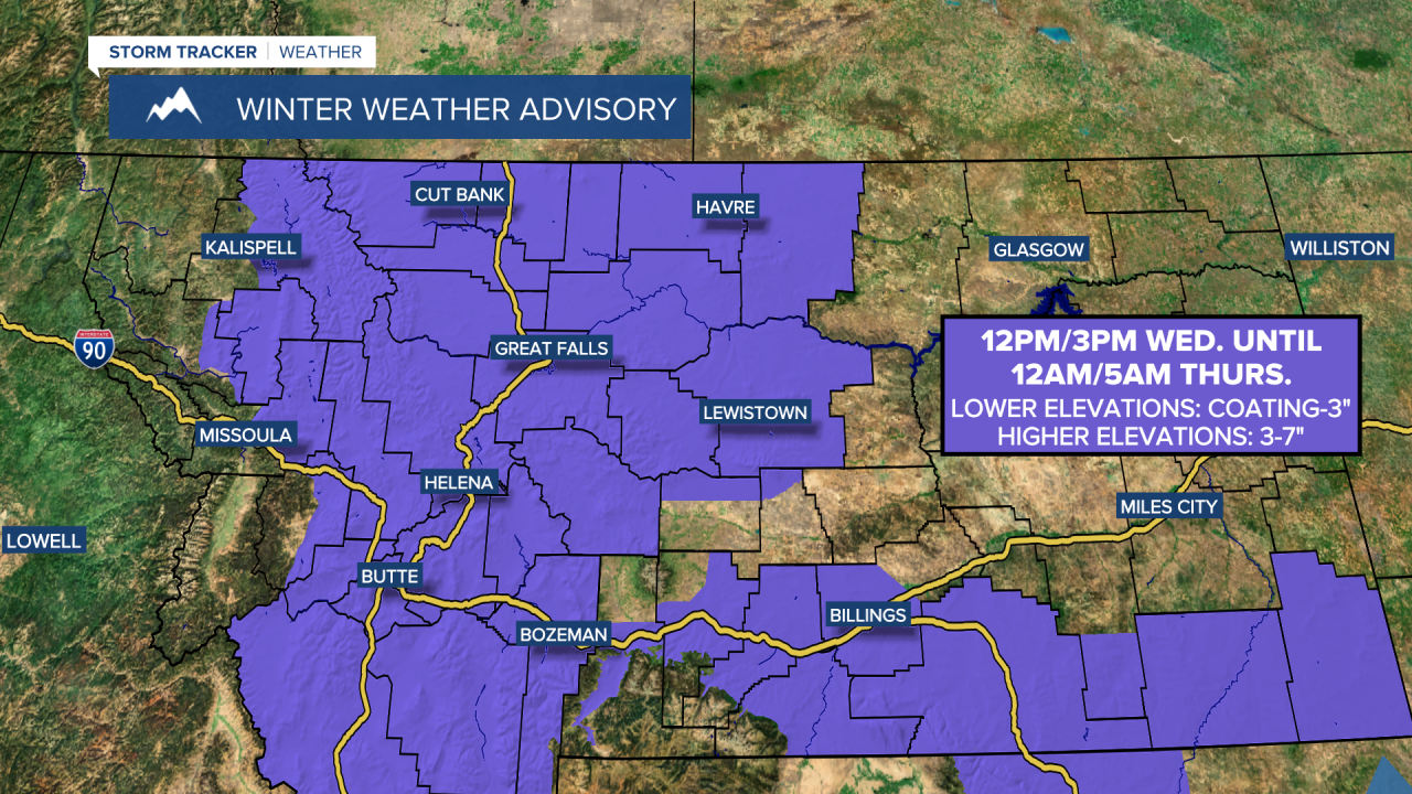
A WINTER WEATHER ADVISORY is in effect from 12pm/3pm Wednesday until 12am/5am Thursday for all of central and north-central Montana. A coating to 3 inches of snow accumulation is expected in the lower elevations, and 3 to 7 inches of snow accumulation is expected in the mountains.
A LAKE WIND ADVISORY is in effect for Fort Peck Lake from 2am Wednesday until 8pm Thursday. Sustained wind speeds are going to be between 20 and 30 mph, and wind gusts over 35 mph are going to be possible at times.

It is going to be chilly tonight as lows are going to be in the teens and low to mid 20s. It is also going to be breezy tonight in some locations (especially those east of I-15) as sustained wind speeds are going to be between 10 and 20 mph. We are also going to have partly to mostly cloudy skies tonight with some isolated snow showers around, generally before midnight and especially in the mountains.
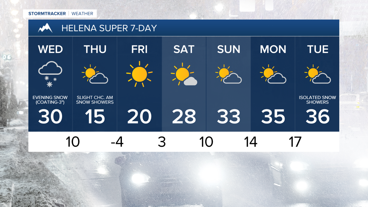
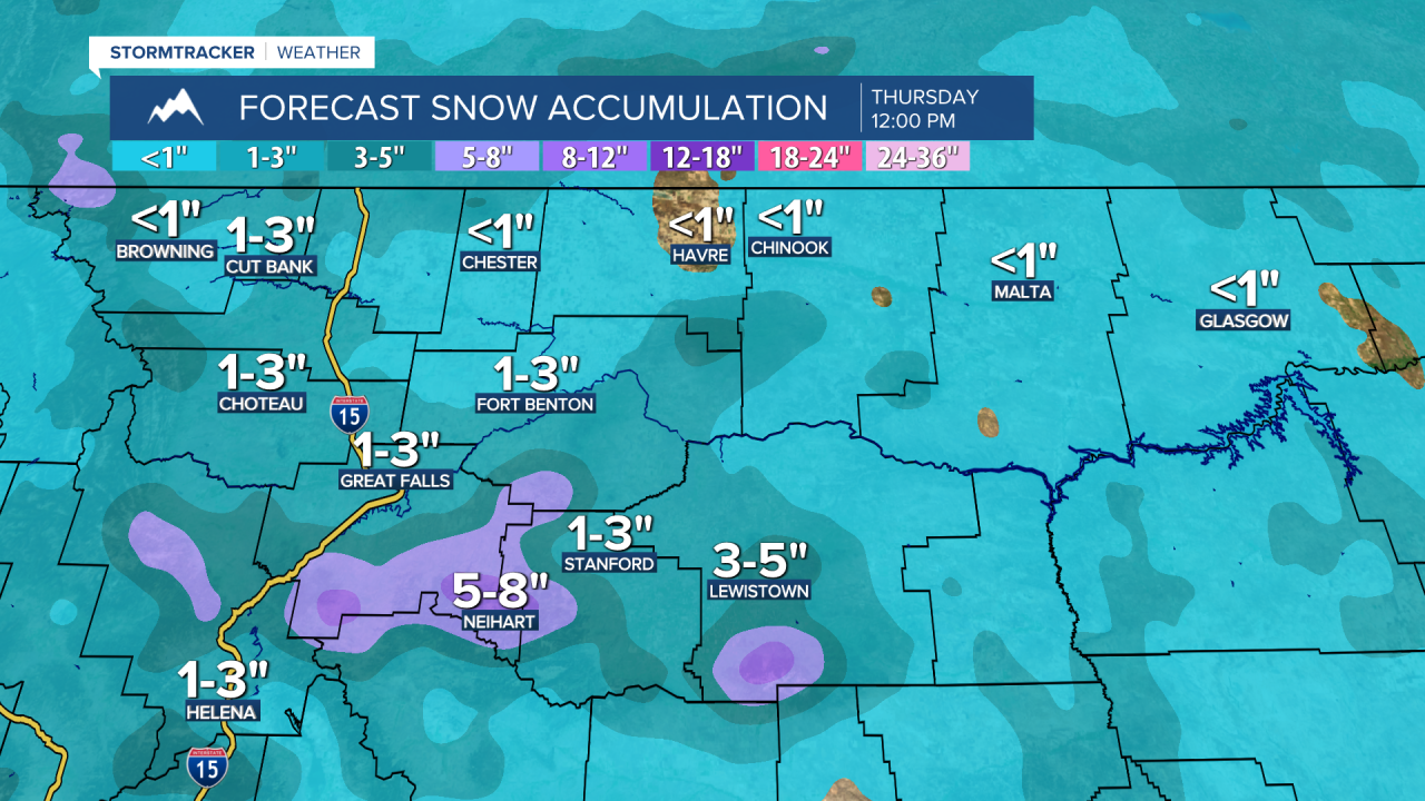
An arctic cold front is then going to bring widespread snow, breezy conditions, and colder temperatures to our area for the second half of tomorrow and tomorrow night. Late tomorrow morning, some light snow is going to begin to develop in northern Montana. The snow will then become more widespread and move southward through north-central and central Montana tomorrow afternoon/evening and early tomorrow night. Behind this main batch of snow, there will be some scattered snow showers around, which will linger through Thursday morning. We are also going to have mostly cloudy to overcast skies tomorrow and decreasing clouds on Thursday.
Since this is a fast-moving cold front, there is not going to be a ton of snow accumulation, with a general coating to 3 inches expected in the lower elevations and 3 to 7 inches expected in the mountains. The roads are going to become slick and/or snow-covered from this snow, so please be careful when traveling, especially during the Wednesday evening commute.
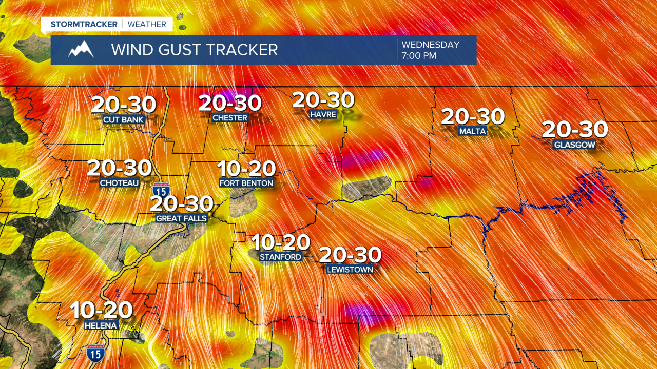
It is going to be breezy throughout the day tomorrow in eastern Montana and eastern portions of north-central Montana, and it is going to become breezy tomorrow afternoon/evening everywhere else as the cold front passes through. Sustained wind speeds are generally going to be between 10 and 25 mph, and some wind gusts up to 40 mph are going to be possible at times. It is then going to continue to be breezy tomorrow night in a lot of central and north-central Montana. This wind is also going to cause there to be areas of blowing snow.
This arctic cold front is also going to bring some much colder air into our area. Highs are going to be in the mid to upper 20s and low to mid 30s on Wednesday, but on Thursday, highs are only going to be in the single digits and teens. Wednesday night, lows are going to be in the single digits above zero, while Thursday night, lows are going to be in the single digits below zero. Wind chills are also going to be below zero in a lot of locations from late Wednesday night through Friday morning.
The plus side to this frigid air is that it is short-lived as the temperatures will rebound into the teens and 20s on Friday and the 20s on Saturday. As the temperatures rebound, the wind will also pick up, as breezy conditions are expected on Friday and Saturday (sustained wind speeds between 10 and 20 mph). We are also going to have mostly sunny skies and dry conditions on Friday and Saturday.
Partly cloudy skies and dry conditions are then expected on Sunday and Monday as high pressure is going to be in control of our weather. We are then going to have partly to mostly cloudy skies on Tuesday with a few isolated snow and rain showers around as a weak disturbance begins to pass through our area. It is also going to be chilly and breezy on these three days as highs are going to be in the 30s and sustained wind speeds are going to be between 10 and 20 mph.