


A WINTER STORM WARNING is in effect for portions of western Montana until 8pm Thursday and for portions of southern and central Montana until 5am/11am Friday.

A WINTER WEATHER ADVISORY is in effect for portions of western Montana until 11pm Thursday or 5am/8am Friday; for portions of central and southwestern Montana until 5am Friday; and for portions of southeastern Montana until 11am Friday.

A WIND CHILL ADVISORY is in effect for the East Glacier area until 11am Thursday and for the West Glacier area until 5am Friday. Wind chills as low as -20° are possible.

Snow is going to become more widespread across central and southern Montana (including around Helena) as we go through tonight, and some of this snow may be heavy at times. Some snow will also develop in southern and western portions of north-central Montana tonight, especially after midnight. Around Helena, tomorrow is going to be a snowy day, although there may be a little bit of a lull in the snow during the middle part of the day. In north-central Montana, there are going to be areas of snow around tomorrow, especially along the Rocky Mountain Front and out to I-15 as well as in Cascade, Fergus, and Judith Basin counties. The Hi-Line east of I-15 will be mostly dry tomorrow with just isolated snow showers around. Some of the snow that falls tomorrow may also be heavy at times, especially around the Helena area. Snow will then gradually taper off as we go through tomorrow night.
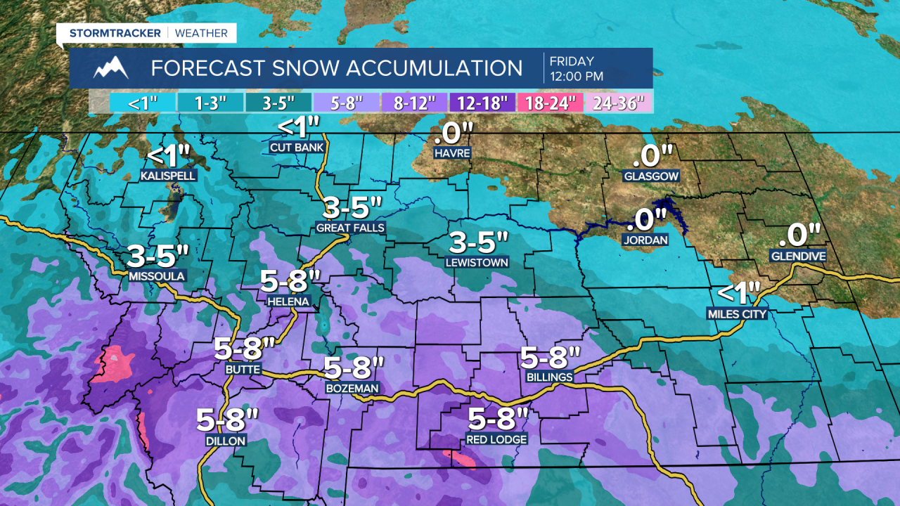
The heaviest snow amounts between this evening and Friday morning are going to be in central and southern Montana. Around the Helena area, 3 to 9 inches of snow accumulation is expected in the lower elevations and 6 to 14 inches of snow accumulation is expected in the mountains. In north-central Montana, the highest snow amounts through Friday morning are going to be along the Rocky Mountain Front and out to I-15 as well as in Cascade, Fergus, and Judith Basin counties, where 1 to 6 inches of snow accumulation is expected in the lower elevations and 5 to 10 inches of snow accumulation is expected in the mountains. Along the Hi-Line east of I-15, less than an inch of snow accumulation is expected for those that do see snow.

Due to this snow, roads are going to be slick/snow-covered in a lot of areas, so please use caution when driving and give yourself some extra time to get to where you need to go. It is also going to be cold tonight and tomorrow as lows tonight are going to be in the -0s, 0s, and 10s, and highs tomorrow are going to be in the teens in most locations. There is also going to be a little bit of a breeze around in some areas tomorrow as sustained wind speeds are going to be between 5 and 20 mph.
Decreasing clouds and mostly dry conditions are then expected on Friday and lots of sunshine and dry conditions are expected on Saturday as high pressure is going to be in control of our weather. On Friday, many locations will start off in the single digits above and below zero during the morning and will top out in the teens and low 20s during the afternoon. Warmer temperatures are then expected on Saturday as highs are going to be in the 30s and mid to upper 20s. It is also going to be breezy in some areas on Saturday as sustained wind speeds are going to be between 10 and 20 mph.
We are then going to have partly to mostly cloudy skies on Sunday with snow showers around the Helena area and a couple isolated snow and rain showers around in north-central Montana (generally in the mountains) as a disturbance passes through our area. Partly cloudy skies and mostly dry conditions (just a few isolated snow/rain showers around) are then expected on Monday, Tuesday, and Wednesday. It is also going to feel nice outside on these four days as highs are going to be in the 30s and low to mid 40s in most locations. There is also going to be a breeze around in some areas on Sunday, Monday, and Tuesday as sustained wind speeds are going to be between 10 and 20 mph.


