


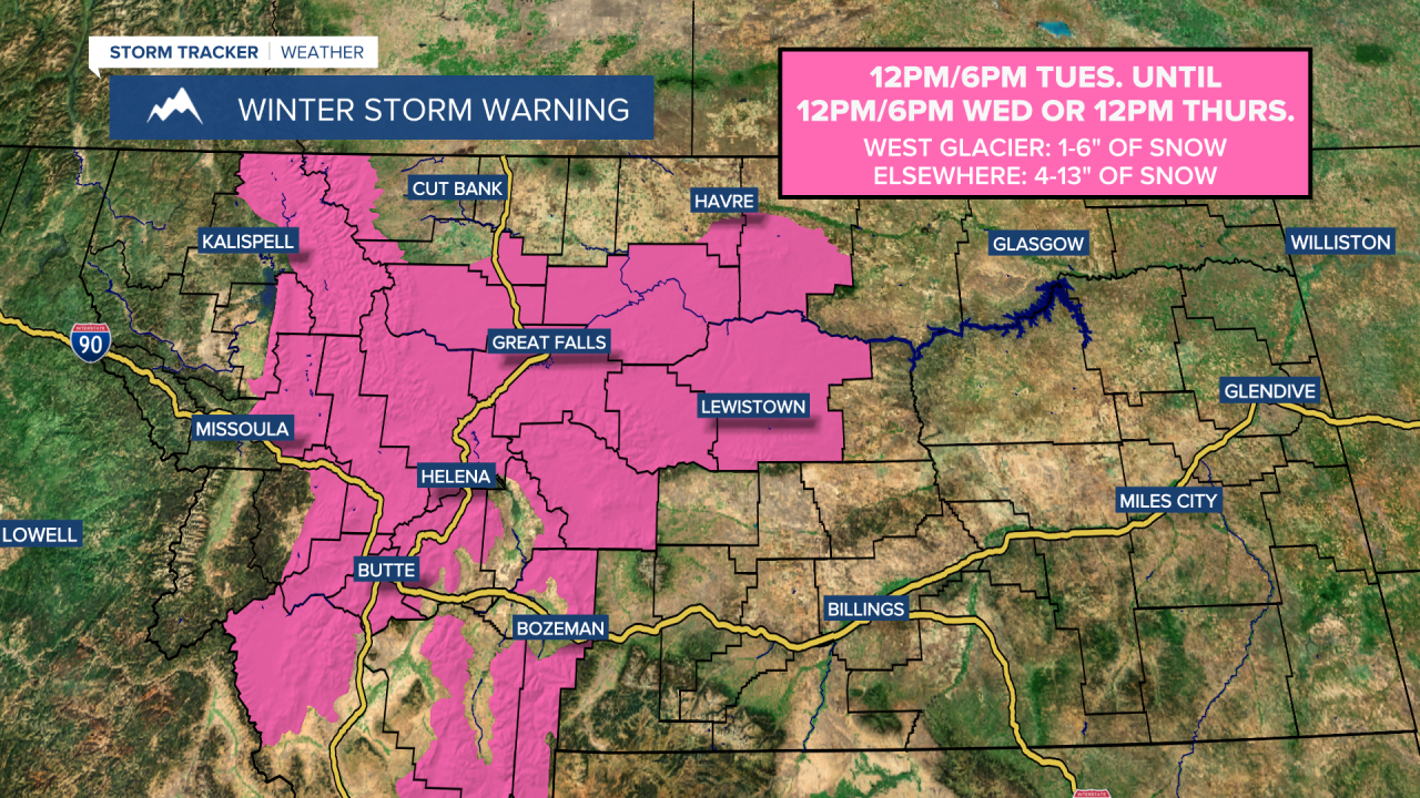
A WINTER STORM WARNING is in effect for a lot of central, western, and southwestern Montana from 12pm/6pm Tuesday until 12pm/6pm Wednesday or 12pm Thursday. 1 to 6 inches of snow accumulation is possible in the West Glacier area. 4 to 13 inches of snow accumulation is possible elsewhere.
A WINTER STORM WATCH is in effect for far western Montana from 6pm Tuesday/12am Wednesday until 12pm Thursday. 1 to 6 inches of snow accumulation is possible, with 7 to 10 inches of snow accumulation possible in the mountains.
A WINTER STORM WATCH is in effect for a lot of central, eastern, and southern Montana from 6pm Tuesday or 3am/6pm Wednesday until 6pm Thursday or 12am/6am Friday. 4 to 16 inches of snow accumulation is possible in northeastern Montana, while 2 to 12 inches of snow accumulation is possible elsewhere. In the mountains in southern Montana, 1 to 2 feet of snow accumulation is possible.

A WINTER WEATHER ADVISORY is in effect for the East Glacier area until 12pm Tuesday and for portions of the Hi-Line and the valleys in southwestern Montana from 6pm Tuesday/12am Wednesday until 6pm Wednesday. 1 to 6 inches of snow accumulation is possible.

There are going to be some scattered rain and snow showers around tonight, especially before midnight and generally along the Hi-Line. We are also going to have partly cloudy skies tonight with areas of fog around, and some of this fog may be dense. It is also going to be chilly tonight as lows are going to be in the 20s and low to mid 30s, and it is going to be breezy tonight along the Rocky Mountain Front and in portions of north-central Montana as sustained wind speeds are going to be between 10 and 20 mph.
For tomorrow, we are going to have increasing clouds with a little snow around during the morning in northwestern Montana and around the Glacier National Park area. Precipitation is then going to become more widespread throughout a lot of the state as we go through tomorrow afternoon and evening. The precipitation may start out as rain in some areas, but it will quickly transition over to snow. Periods of widespread snow are then expected from tomorrow night through Thursday as a couple storm systems pass through our area. Some of the snow that falls tomorrow night through Thursday may also be heavy at times, especially in central and southern Montana.
Per usual, snow amounts are going to vary a lot with this storm system. Between this evening and Wednesday evening, the lowest snow amounts are going to be along the Hi-Line, in northwestern and southwestern Montana as well as in southeastern Montana where a coating to 6 inches of snow accumulation is expected. Elsewhere, 4 to 12 inches of snow accumulation is expected through Wednesday evening, with localized areas potentially receiving up to 18 inches of snow accumulation. Additional snow accumulation is expected from Wednesday night through Friday morning, which will add to these snow totals. Also, this snow is also going to create slick and snow-covered roads, so please use extreme caution when driving and give yourself plenty of extra time to get to where you need to go.

We are also going to have well-below average temperatures tomorrow, Wednesday, and Thursday. Tomorrow, highs are going to range from the mid 20s to the mid 40s, with the warmest temperatures in northeastern Montana and around the Helena area. Highs are then going to be in the 20s and mid to upper teens in most locations on Wednesday and Thursday, with lows at night in the single digits and teens. It is also going to be a bit breezy tomorrow through Wednesday as sustained wind speeds are going to be between 10 and 20 mph, and this wind is going to make it feel even colder.
There are then going to be some scattered snow showers around on Friday, especially during the morning, as this week’s storm system finally leaves our area. We are also going to have mostly to partly cloudy skies and cold temperatures on Friday as highs are going to be in the upper teens and low to mid 20s.
On Saturday, we are going to have partly cloudy to mostly sunny skies with some isolated snow showers around. We are then going to have mostly to mainly sunny skies and mostly dry conditions on Sunday and Monday. The temperatures are also going to slowly warm back up over these three days as highs are going to be in the low to mid 20s on Saturday, and the mid to upper 20s and low to mid 30s on Sunday and Monday. It is also going to be a bit breezy on Sunday and Monday as sustained wind speeds are going to be between 10 and 20 mph.


