


A WINTER WEATHER ADVISORY is in effect for Cascade County, Fergus County, Judith Basin County, and Meagher County until 6pm Saturday. 2 to 10 inches of total snow accumulation is possible in the mountains.
A WINTER WEATHER ADVISORY is in effect for southern Valley County from 12am Saturday until 6am Sunday. A few inches of snow accumulation and a light glaze of ice is possible.

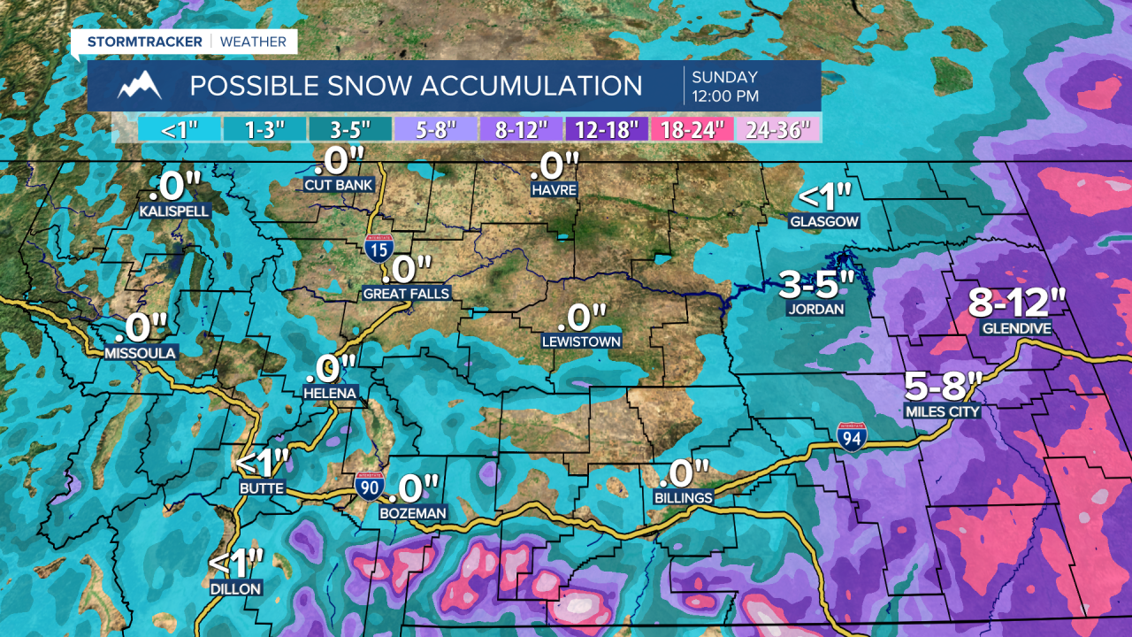
There are also WINTER STORM WARNINGS and BLIZZARD WARNINGS in effect for portions of southern and eastern Montana through Saturday or Sunday. Up to two feet of snow accumulation is possible, and strong winds will create blizzard conditions in eastern Montana.

A LAKE WIND ADVISORY is in effect for the western part of Fort Peck Lake from 12am Saturday until 6am Sunday. Sustained wind speeds are going to be between 20 and 30 mph, and wind gusts over 40 mph are going to be possible at times.

A blizzard is going to develop in eastern Montana tonight. In central Montana, there are going to be some scattered rain and snow showers around tonight. For tomorrow, snow is likely in far eastern Montana and there are going to be scattered rain and snow showers around in central Montana. These showers will then taper off tomorrow night and the skies will begin to clear as this storm system departs our area.
In the mountains in central Montana, up to a foot of total snow accumulation is possible. In the lower elevations in central Montana, up to an inch or two of snow accumulation is possible, but most locations are going to receive no snow accumulation. In Valley County, up to 4 inches of snow accumulation is possible.
The wind is also going to pick up later tonight, with breezy conditions (10-25 mph sustained winds) expected in east-central and eastern Montana after midnight. It is then going to be windy tomorrow in eastern Montana as sustained wind speeds are going to be between 20 and 35 mph, and wind gusts over 50 mph are going to be possible at times. In central Montana, we are going to have gusty winds around tomorrow as sustained wind speeds are going to be between 10 and 30 mph, and wind gusts up to 40 mph are going to be possible at times. It is also going to be cool tonight and tomorrow as lows tonight are going to be in the 30s in most locations, and highs tomorrow are going to range from the upper 30s to the low 50s.
On Sunday, we are going to have partly cloudy skies and there are going to be some isolated rain and snow showers around, generally in the mountains. We are also going to have seasonable temperatures on Sunday as highs are going to be in the 50s. There is also not going to be much wind around on Sunday in central Montana, but it is going to be breezy in east-central and eastern Montana as sustained wind speeds are going to be between 10 and 25 mph.
Partly to mostly cloudy skies and mainly dry conditions are then expected on Monday as high pressure is going to be in control of our weather. We are then going to have mostly cloudy skies with a chance of PM lower elevation rain and higher elevation rain/snow showers on Tuesday as a disturbance begins to pass through our area. A few thunderstorms are also possible Tuesday afternoon and evening.
It is also going to feel really nice outside on Monday and Tuesday as highs are going to be in the 60s, and a few spots may even top out in the low 70s. There is also going to be a little bit of a breeze around on Monday as sustained wind speeds are going to be between 10 and 15 mph. It is then going to be breezy on Tuesday, especially during the afternoon and evening, as sustained wind speeds are going to be between 10 and 20 mph.
We are then going to have partly cloudy skies and mostly dry conditions on Wednesday. It is also going to be windy on Wednesday as sustained wind speeds are going to be between 15 and 30 mph, and wind gusts over 40 mph are going to be possible at times. The temperatures are also going to be cooler on Wednesday than they are going to be on Monday and Tuesday as highs are going to be in the mid to upper 50s and low 60s.
On Thursday, there are going to be some scattered lower elevation rain and higher elevation snow/rain showers around, generally during the afternoon and evening, as a storm system begins to approach our area. A mix of rain and snow is then likely on Friday as this storm system passes through our area. The temperatures are also going to cool down some over these two days as highs are going to be in the 50s on Thursday and the 40s on Friday. There is also going to be a little bit of a breeze around on these two days as sustained wind speeds are going to be between 5 and 20 mph.


