A WINTER WEATHER ADVISORY is in effect for the mountains in western Montana from 12am until 6pm Thursday. 1 to 10 inches of snow accumulation is expected above 6000 feet, with the snow accumulation increasing as you go up in elevation.

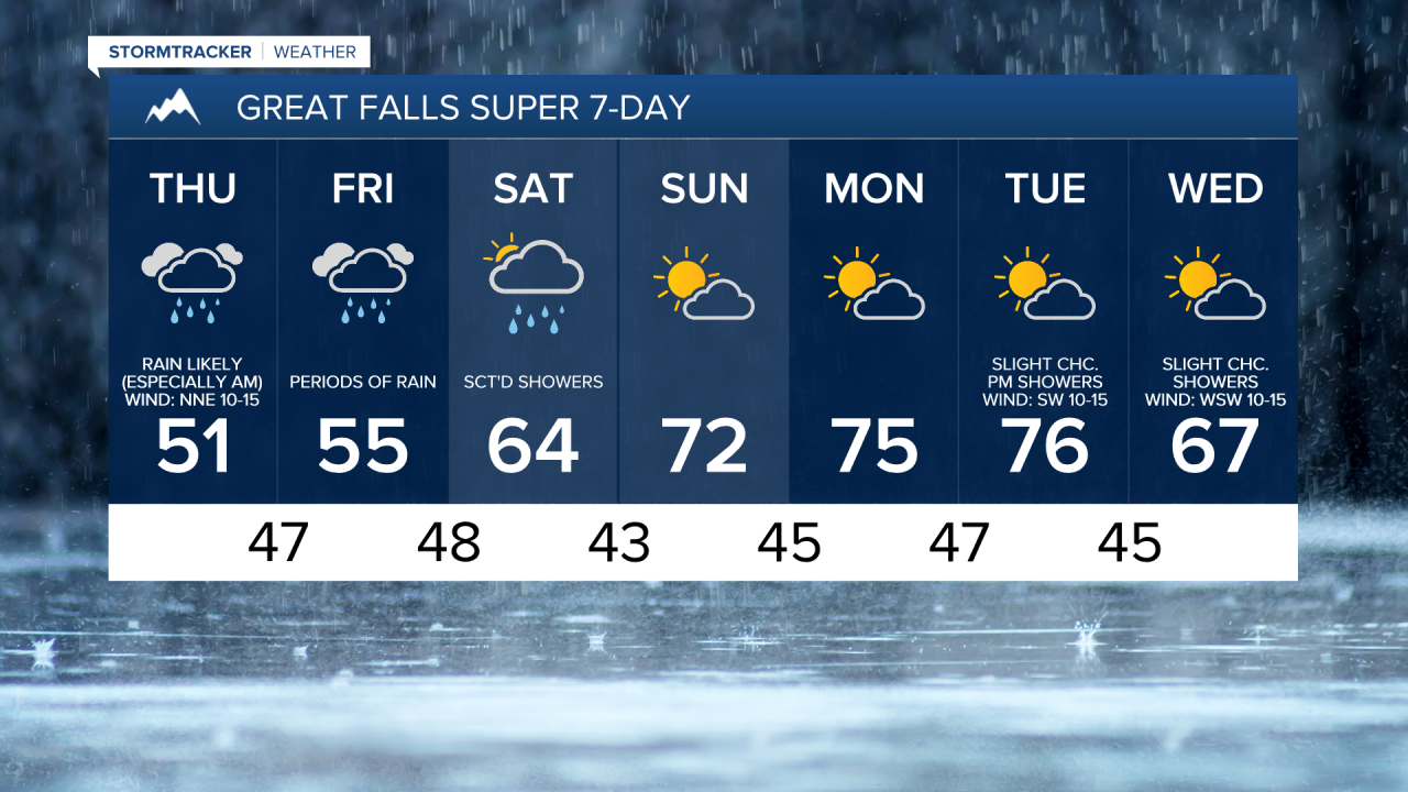
Precipitation is going to become more widespread as we go through tonight, especially once we get past midnight, as a storm system begins to impact our area. Precipitation is then likely tomorrow, especially during the morning. For tonight and tomorrow, this precipitation is going to be in the form of rain in the lower elevations and a mix of snow and rain in the mountains, with snow levels getting as low as 6000-6500 feet. We are also going to have mostly cloudy to overcast skies tonight and tomorrow.
Showers are then likely tomorrow night, and periods of rain are expected on Friday as this storm system continues to work its way through our area. We are also going to continue to have mostly cloudy to overcast skies tomorrow night and Friday. On Saturday, we are going to have mostly to partly cloudy skies with scattered showers around, generally in locations east of I-15, as this storm system finally begins to leave our area. All-in-all, between Wednesday evening and Saturday evening, a general .5 to 2 inches of rainfall is expected throughout much of central and north-central Montana.
It is also going to be chilly/cool tomorrow and Friday as highs are going to be in the 50s and mid to upper 40s in most locations tomorrow, and the 50s and low to mid 60s in most locations on Friday. It is also going to be breezy tonight and tomorrow as sustained wind speeds are going to be between 10 and 25 mph, and wind gusts up to 40 mph are possible. Warmer temperatures are then expected on Saturday as highs are going to be in the mid to upper 50s and low to mid 60s.
Partly cloudy skies and mostly dry conditions are then expected on Sunday, Monday, and Tuesday as an upper-level ridge is going to be in control of our weather. It is also going to be mild on these three days as highs are going to be in the upper 60s and low to mid 70s on Sunday and the 70s on Monday and Tuesday. It is also going to be a little breezy on Tuesday as sustained wind speeds are going to be between 5 and 20 mph.
Some isolated showers are then possible on Wednesday as a disturbance passes through our area. We are also going to have partly cloudy skies and cooler temperatures on Wednesday as highs are going to be in the 60s and low 70s.