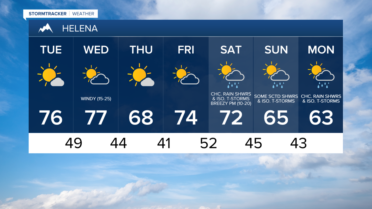
We are going to have mostly clear skies tonight with some isolated rain showers and thunderstorms around, mainly before midnight. It is also going to be cool tonight as lows are going to be in the upper 30s and low to mid 40s in most locations.
For tomorrow, we are going to have increasing clouds and mainly dry conditions as high pressure is going to be in control of our weather. We are then going to have partly cloudy skies with a slight chance of rain showers and thunderstorms on Wednesday as a cold front passes through our area. The temperatures tomorrow and Wednesday are also going to be near average for this time of year as highs are going to be in the 70s in most locations. There is also going to be a little bit of a breeze around in spots tomorrow as sustained wind speeds are going to be between 5 and 15 mph. It is then going to be windy on Wednesday as sustained wind speeds are going to be between 15 and 30 mph, and wind gusts up to 45 mph are going to be possible in the valleys, while wind gusts up to 60+ mph are going to be possible along the Rocky Mountain Front.
On Thursday, we are going to have mostly sunny skies with a slight chance of rain showers and thunderstorms in locations east of I-15. We are then going to have partly to mostly cloudy skies with a slight chance of rain showers and thunderstorms, mainly in locations west of I-15, on Friday. It is also going to be cooler on Thursday than it is going to be over the next couple of days as highs are only going to be in the mid to upper 60s in most locations. The temperatures are then going to warm back up some on Friday as highs are going to be in the upper 60s and low to mid 70s in most locations. There is also going to be a bit of a breeze around on Friday as sustained wind speeds are going to be between 10 and 20 mph.
We are then going to have partly cloudy skies with a chance of rain showers and isolated thunderstorms on Saturday and Sunday as a cold front passes through our area. Some higher elevation snow is also possible this weekend. The temperatures are also going to cool down some this weekend as highs on Saturday are going to be in the upper 60s and low to mid 70s in most locations, and highs on Sunday are going to be in the mid 60s in most locations. It is also going to be windy on Saturday, especially during the afternoon and evening, as sustained wind speeds are going to be between 15 and 30 mph, and it is going to be breezy on Sunday, especially during the afternoon and evening, as sustained wind speeds are going to be between 10 and 20 mph.
For next Monday, we are going to have a chance to see some more valley rain and mountain rain/snow showers as another disturbance passes through our area. It is also going to be cool next Monday as highs are going to be in the low to mid 60s in most locations.