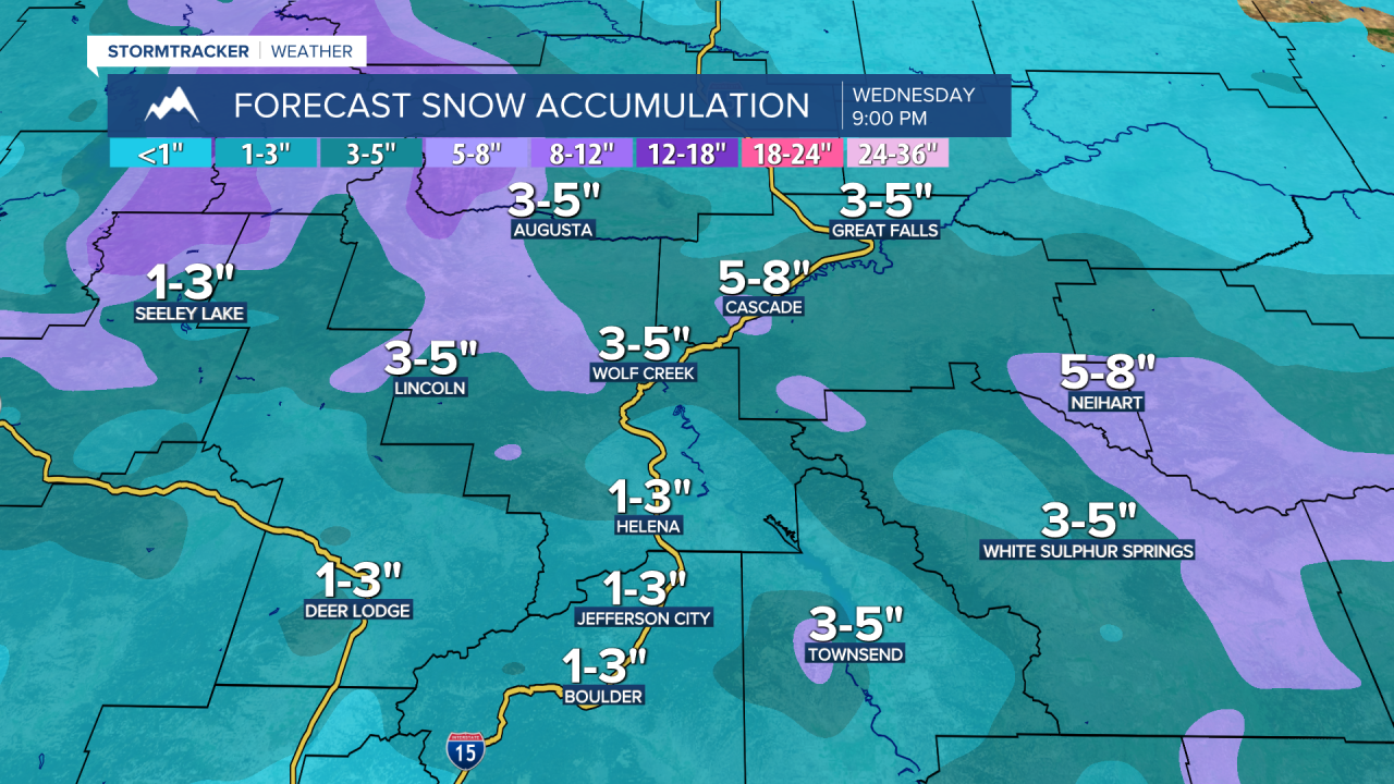
A WINTER WEATHER ADVISORY is in effect for the Glacier National Park area, the Rocky Mountain Front, and portions of central Montana until 5am Wednesday. 1-5" of snow accumulation is expected in the lower elevations, and up to 12" of new snow accumulation is possible in the mountains.
A WINTER WEATHER ADVISORY is also in effect for the Potomac/Seeley Lake region until 11am Tuesday and for the Kootenai/Cabinet region and the Flathead/Mission valleys from Tuesday afternoon through Wednesday morning. Up to 3" of new snow accumulation is possible.

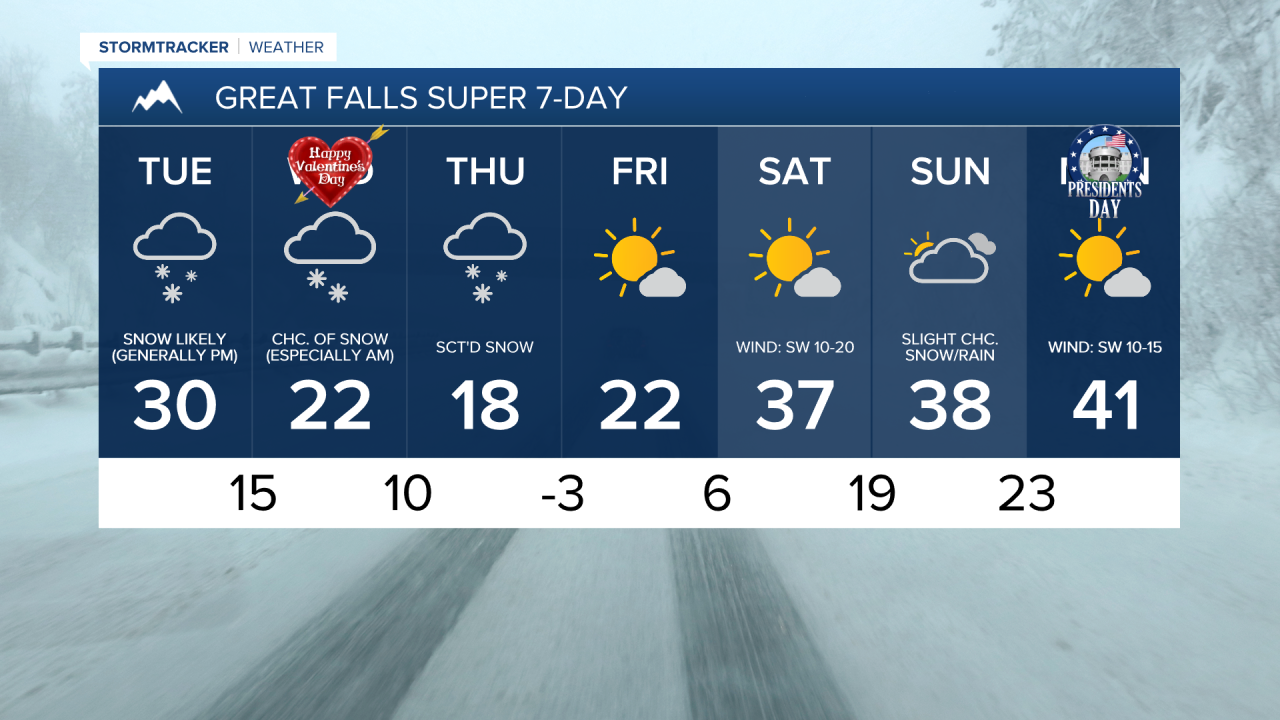
There are going to be scattered areas of snow around tonight, especially in central Montana (including around Great Falls, Helena, and Lewistown) and between the Continental Divide and I-15, as a disturbance passes through our area. A little rain is also possible this evening. There are then going to be scattered areas of snow around tomorrow (especially during the afternoon and evening) and tomorrow night (especially before midnight and especially in central Montana and in between the Continental Divide and I-15) as another disturbance passes through our area. We are also going to have mostly cloudy to overcast skies tonight and tomorrow.
There is then going to be some scattered snow around on Wednesday, especially during the morning and especially in central Montana, as we are going to be in between disturbances. We are also going to have mostly to partly cloudy skies on Wednesday, with the most sunshine along the Hi-Line.
Between Monday evening and Wednesday evening, the highest snow amounts in the lower elevations will be along the Rocky Mountain Front and out to the I-15 corridor as well as in central Montana, including in Broadwater, Cascade, Fergus, Jefferson, Judith Basin, Lewis and Clark, and Meagher counties, where 1 to 5 inches of snow accumulation is expected. Elsewhere, up to 2 inches of snow accumulation is possible, but most locations will receive less than an inch of snow accumulation. Also, in the mountains, up to a foot of new snow accumulation is possible through Wednesday evening. This snow will create slippery road conditions, so please use caution when driving and give yourself some extra time to get to where you need to go.
It is also going to be a little breezy in some areas tonight and tomorrow as sustained wind speeds are going to be between 5 and 20 mph. Tonight, lows are going to be in the mid to upper teens and low to mid 20s. The temperatures are then going to cool down some over the next two days as highs are going to be in the mid to upper 20s and low to mid 30s tomorrow and the upper teens and low to mid 20s on Wednesday.
Some more snow is then expected Wednesday night and Thursday, generally in locations south of the Hi-Line, as another disturbance impacts our area. An additional coating to 3 inches of snow accumulation is possible in the lower elevations with this disturbance. We are also going to have mostly to partly cloudy skies on Thursday, with the most sunshine along the Hi-Line. It is also going to be chilly on Thursday as highs are going to be in the teens, and it is going to be a little breezy in some areas on Thursday as sustained wind speeds are going to be between 5 and 20 mph.
Mostly sunny skies and mostly dry conditions are then expected on Friday and Saturday as high pressure is going to be in control of our weather. On Friday, many locations will start off in the single digits above and below zero during the morning and will top out in the mid to upper teens and low to mid 20s during the afternoon. Warmer temperatures are then expected on Saturday as highs are going to be in the mid to upper 20s and low to mid 30s. It is also going to be breezy in some areas on Saturday as sustained wind speeds are going to be between 10 and 20 mph.
We are then going to have mostly cloudy skies with some isolated snow and rain showers around on Sunday as a disturbance passes through our area. Partly to mostly sunny skies and mostly dry conditions are then expected on Monday. It is also going to feel nice outside on these two days as highs are going to be in the 30s and low to mid 40s in most locations. There is also going to be a little breeze around in some areas on these two days as sustained wind speeds are going to be between 5 and 20 mph.