


A WINTER WEATHER ADVISORY is in effect for the mountains in western Montana until 12pm Friday. Up to 5 inches of new snow accumulation is possible above 6500 feet.
A WINTER WEATHER ADVISORY is in effect for the Absaroka and Beartooth mountains until 12pm Saturday. 2 to 10 inches of snow accumulation is possible above 9000 feet.

Periods of rain and mountain rain/snow are expected through Friday night as a storm system slowly passes by our area to the south. A few isolated thunderstorms are also possible through Friday night. There are then going to be some scattered showers around on Saturday, generally in locations east of I-15 and especially during the morning, as this storm system slowly moves away from our area. We are also going to have overcast skies through Friday night, with decreasing clouds on Saturday. There are also going to be some areas of fog around tonight, tomorrow, and tomorrow night.
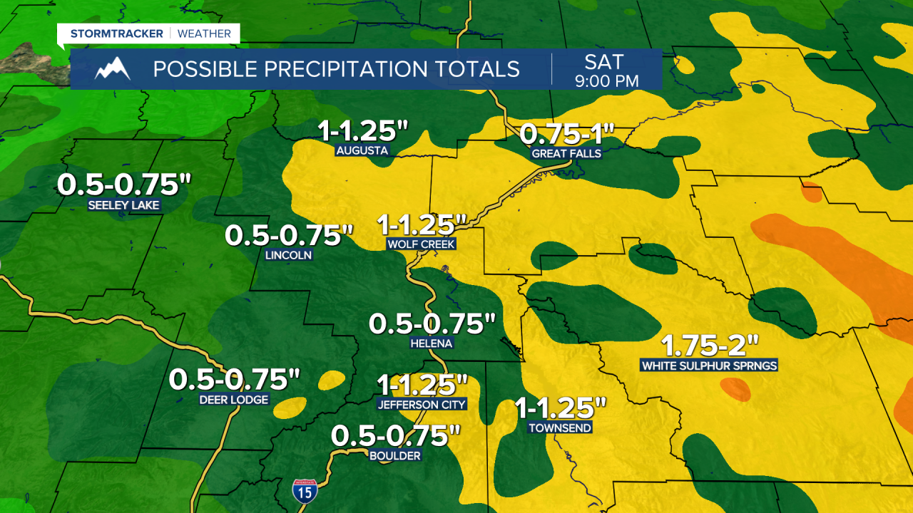
Many locations have already received between .1” and .75” of precipitation during the day today (as of 6pm), and an additional .5” to 1.5” of precipitation is expected between this evening and Saturday evening in a lot of central and eastern Montana, with localized higher amounts possible. This precipitation may also lead to some localized flooding, especially where some heavier rainfall falls.
It is going to be cool tonight and tomorrow as lows tonight are going to be in the 40s and low to mid 50s, and highs tomorrow are going to be in the 50s and 60s, with the warmest temperatures along the eastern half of the Hi-Line. It is also going to be breezy tomorrow in locations east of I-15 as sustained wind speeds are going to be between 10 and 25 mph, and wind gusts up to 40 mph are possible. The temperatures are then going to warm up some on Saturday as highs are going to be in the 60s in most locations.
Partly cloudy skies and dry conditions are then expected on Sunday and Monday as an upper-level ridge is going to be in control of our weather. It is also going to be mild on these two days as highs are going to be in the upper 60s and low to mid 70s on Sunday and the 70s on Monday.
On Tuesday, we are going to have partly cloudy to mostly sunny skies with some isolated showers and thunderstorms around during the afternoon and evening as a disturbance begins to impact our area. It is also going to be mild and breezy on Tuesday as highs are going to be in the 70s in most locations and sustained wind speeds are going to be between 10 and 20 mph.
We are then going to have partly cloudy skies on Wednesday and Thursday with some isolated showers and thunderstorms around on Wednesday as Tuesday’s disturbance leaves our area, and a couple isolated showers and thunderstorms around on Thursday as another disturbance begins to impact our area. It is also going to be cooler and a bit breezy on these two days as highs are going to be in the 60s and low 70s in most locations, and sustained wind speeds are going to be between 10 and 20 mph.


