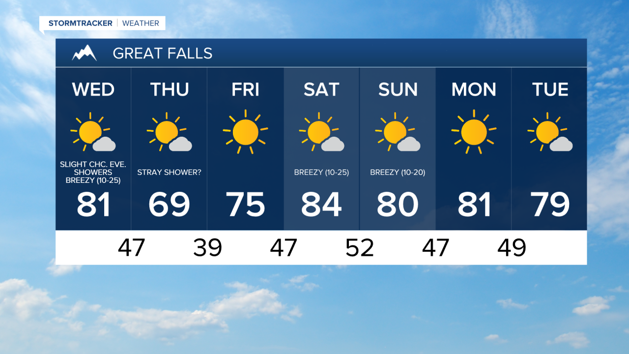
We are going to have mostly to mainly clear skies and chilly temperatures tonight as lows are going to be in the upper 30s and low to mid 40s in most locations. We are then going to have mostly sunny skies tomorrow with a slight chance of evening rain showers as an upper-level disturbance begins to approach our area. The high temperatures tomorrow are also going to be warmer than the high temperatures today were as highs are going to be in the mid to upper 70s and low to mid 80s in most locations. It is also going to be breezy tomorrow, especially during the afternoon and evening, as sustained wind speeds are going to be between 10 and 25 mph, and wind gusts up to 40 mph are going to be possible at times. This wind combined with warm temperatures and low relative humidity is also going to create elevated fire weather conditions tomorrow. Also, Fall starts tomorrow at 1:21pm MDT!
For tomorrow night, we are going to have partly cloudy skies with a slight chance of rain showers as an upper-level disturbance continues to pass through our area. There is also going to be a little bit of haze around tomorrow night, especially in south-central Montana. It is also going to be cool tomorrow night as lows are going to be in the mid to upper 40s and low 50s in most locations.
We are then going to have partly cloudy to mostly sunny skies with a slight chance of rain showers on Thursday as this upper-level disturbance departs our area. It is also going to be cooler on Thursday than it is going to be tomorrow as highs are only going to be in the mid to upper 60s and low 70s in most locations. There is also going to be a little bit of a breeze around in central Montana on Thursday as sustained wind speeds are going to be between 10 and 15 mph. In eastern Montana, it is going to be breezy on Thursday, especially during the afternoon and evening, as sustained wind speeds are going to be between 10 and 20 mph.
Mostly to mainly sunny skies and dry conditions are then expected on Friday, Saturday, Sunday, and Monday as an upper level ridge is going to be in control of our weather. The temperatures on these four days are also going to be above average for this time of year as highs on Friday are going to be in the 70s in most locations, and highs this weekend and on Monday are going to be in the upper 70s and low to mid 80s in most locations. It is also going to be breezy on Saturday and Sunday, especially during the PM hours, as sustained wind speeds are going to be between 10 and 25 mph. This wind coupled with low relative humidity and warm temperatures is also going to create elevated fire weather conditions this weekend.