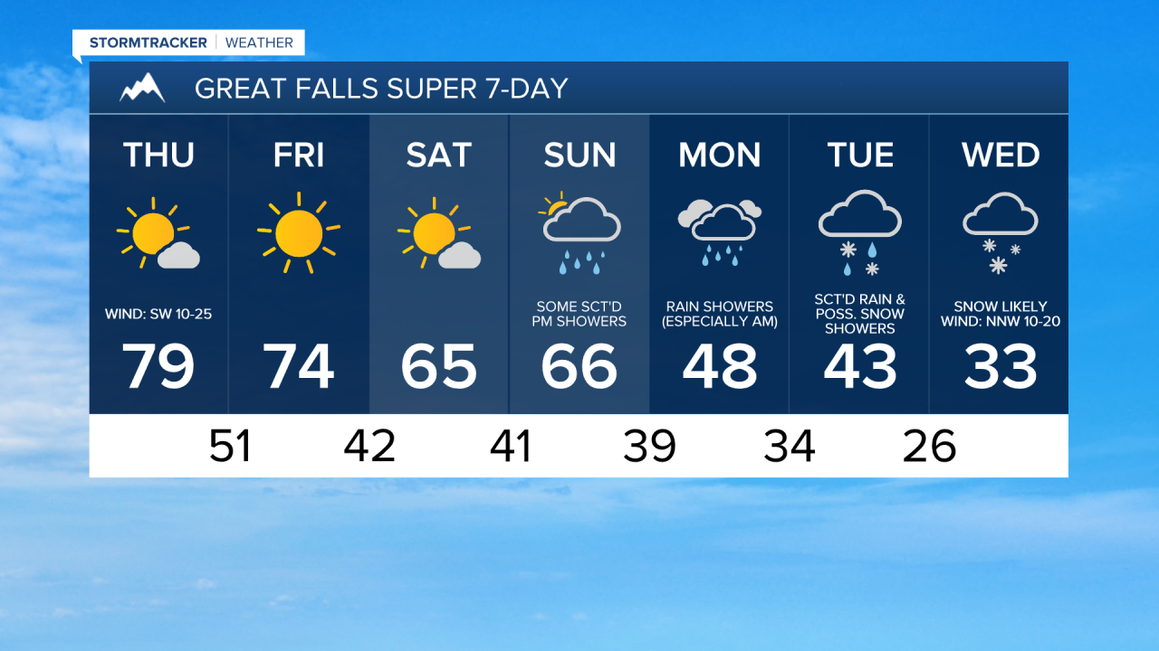
It is going to continue to be windy tonight and tomorrow along the Rocky Mountain Front as wind gusts over 50 mph are possible. Elsewhere, it is going to be breezy tonight with sustained wind speeds between 10 and 20 mph (gusts up to 30 mph), and it is going to be gusty tomorrow with sustained wind speeds between 10 and 25 mph (gusts up to 40 mph). Also, the wind tonight and tomorrow is going to be coming out of the west or the southwest in most locations.
We are also going to have partly cloudy to mostly clear skies and mainly dry conditions tonight, and mostly to mainly sunny skies tomorrow as high pressure is going to be in control of our weather. It is also going to be cool tonight as lows are going to be in the 40s and low 50s in most locations. It is then going to be warm tomorrow as highs are going to be in the 70s and low 80s, and this is likely going to be the warmest day that we are going to have until next year.
On Friday, we are going to have mostly to mainly sunny skies and mainly dry conditions. We are also still going to have above average temperatures on Friday, although it is not going to be quite as warm as it is going to be tomorrow as highs are going to be in the mid to upper 60s and low to mid 70s, with the coolest temperatures along the Hi-Line. The wind is also going to be less of a nuisance on Friday as it is just going to be a bit breezy in some areas as sustained wind speeds are going to be between 5 and 20 mph.
For this weekend, we are going to have partly cloudy to mostly sunny skies and dry conditions on Saturday, and mostly cloudy skies with some scattered showers around during the afternoon and evening on Sunday as the next storm system begins to approach our area. We are also going to continue to have above average temperatures this weekend as highs are going to be in the 60s in most locations.
Rain and mountain snow showers are then likely on Monday, especially during the morning, as a storm system continues to work its way through our area. Snow may also mix in with this rain in some lower elevation locations during the morning. It is also going to be a lot colder on Monday than it is going to be this weekend as highs are going to be in the 40s and low 50s.
Scattered rain/snow showers are then expected on Tuesday, especially during the evening, as the next storm system begins to impact our area. Widespread snow (including in the lower elevations) is then likely on Wednesday as this storm system continues to impact our area. The temperatures are also going to cool down even more over these two days as highs on Tuesday are going to be in the mid to upper 30s and low to mid 40s, and highs on Wednesday are going to be in the mid to upper 20s and low to mid 30s. It is also going to be a bit breezy on these two days as sustained wind speeds are going to be between 10 and 20 mph.