


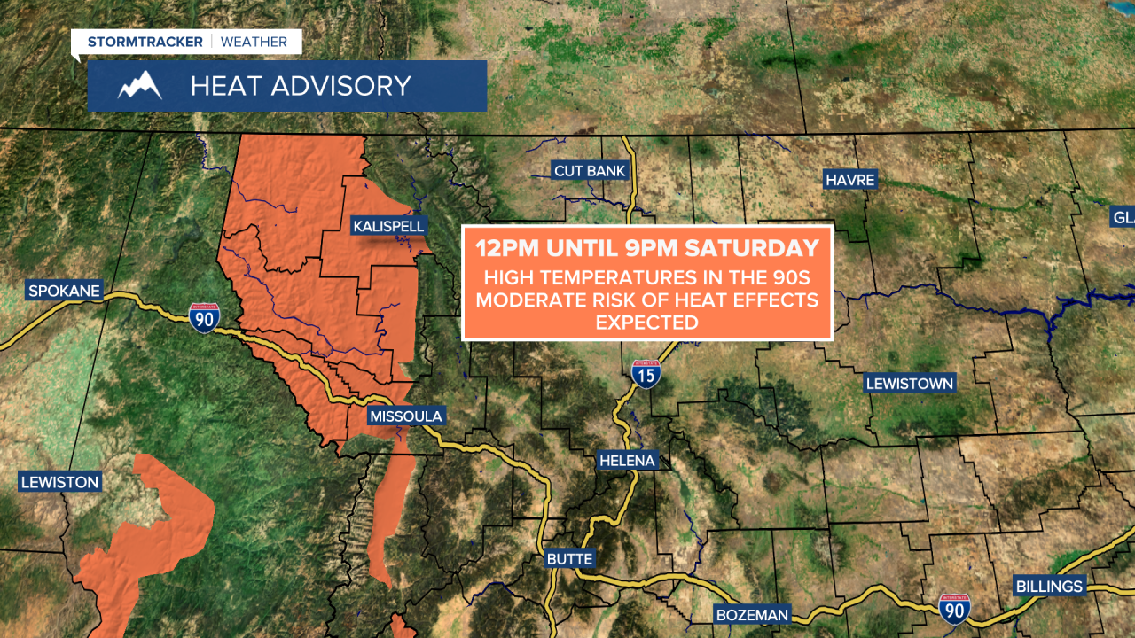
A HEAT ADVISORY is in effect for portions of western Montana from 12pm until 9pm Saturday.
We are going to have clear skies and pleasant temperatures tonight as lows are going to be in the mid to upper 40s and low 50s. The wind is also going to be calm tonight.
Tomorrow is going to be the hottest day of the year so far in a lot of locations as highs are going to be in the mid to upper 80s and low to mid 90s. Several locations will likely set a new record high temperature tomorrow, including Great Falls and Helena. We are also going to have mostly sunny skies and dry conditions tomorrow. There is also going to be a little breeze around tomorrow as sustained wind speeds are going to be between 5 and 20 mph.

A cold front is then going to bring some changes to our weather for the second half of this weekend. On Sunday, we are going to have partly cloudy skies with some scattered showers/storms around, especially during the afternoon/evening, as a cold front passes through our area. It is also going to be a lot cooler on Sunday than it is going to be tomorrow as highs are going to be in the mid to upper 60s and low to mid 70s. There is also going to be a breeze around on Sunday as sustained wind speeds are going to be between 10 and 25 mph, with the strongest wind in eastern portions of north-central Montana and the weakest wind in western portions of north-central Montana (around and west of I-15).

Also, due to smoke from Canadian wildfires, it will be hazy/smoky throughout the weekend in northeastern Montana, including in Valley County, and a brief period of haze/smoke is possible in north-central Montana on Sunday with the passage of the cold front.
Monday will be the coolest and wettest day of the next week as a storm system passes through our area. On Monday, there are going to be scattered showers and isolated thunderstorms around, especially during the morning and especially in locations east of I-15. It is also going to be cool and a bit breezy on Monday as highs are going to be in the mid to upper 50s and low to mid 60s, and sustained wind speeds are going to be between 10 and 20 mph. We are also going to have partly to mostly cloudy skies on Monday.
On Tuesday, we are going to have partly cloudy skies with a chance of showers and thunderstorms during the afternoon and evening, generally in central Montana. It is also going to be a little warmer on Tuesday than it is going to be on Monday as highs are going to be in the 60s and low 70s.
We are then going to have partly cloudy skies and mostly dry conditions Wednesday through Friday as high pressure is going to be in control of our weather. We are also going to have pleasant temperatures on these three days as highs are going to be in the 70s and low 80s in most locations. There is also going to be a breeze around in some areas on Thursday and Friday as sustained wind speeds are going to be between 10 and 20 mph.


