


We are going to have partly to mostly cloudy skies tonight with a chance of a few valley rain and mountain rain/snow showers as a cold front continues to work its way through our area. It is also going to be cool tonight as lows are going to be in the upper 30s and low to mid 40s in most locations. We are also going to have diminishing wind this evening and early tonight.
For tomorrow, we are going to have decreasing clouds with a chance of a few valley rain and mountain rain/snow showers, mainly during the morning and mainly in north-central Montana. The temperatures tomorrow are also going to be cooler than the temperatures over the past few days have been as highs are only going to be in the upper 50s and low to mid 60s in most locations. There is also going to be a bit of a breeze around tomorrow, especially in eastern Montana, as sustained wind speeds are going to be between 5 and 20 mph.
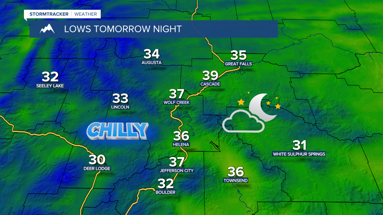
We are then going to have increasing clouds and dry conditions tomorrow night. It is also going to be chilly tomorrow night as lows are going to be in the low to mid 30s in most locations. There are also going to be areas of frost around tomorrow night, so make sure you protect any sensitive plants/vegetation that you may have.
On Friday, we are going to have partly to mostly cloudy skies with a slight chance of rain showers, mainly during the evening. It is also going to be warmer on Friday than it is going to be tomorrow as highs are going to be in the 70s in most locations. Breezy conditions are also expected on Friday, especially during the afternoon and evening, as sustained wind speeds are going to be between 10 and 20 mph.
Saturday is then going to have partly cloudy to mostly sunny skies with some isolated rain showers around, mainly in locations along the Continental Divide, as another cold front passes through our area. It is also going to be warm on Saturday as highs are going to be in the upper 70s and low 80s in most locations, and it is going to be windy on Saturday as well, especially during the afternoon and evening, as sustained wind speeds are going to be between 15 and 30 mph, and wind gusts up to 50 mph are going to be possible at times.
We are then going to have increasing clouds with some scattered rain showers around, generally during the afternoon and evening, on Sunday as a storm system begins to approach our area. Valley rain and mountain rain/snow is then likely Sunday night and Monday as this storm system passes through our area. Light to moderate snow accumulations are also possible in the mountains over these two days.
The temperatures are also going to cool down a lot over these two days as highs on Sunday are going to be in the 60s in most locations, and highs on Monday are only going to be in the 50s in most locations. It is also going to be breezy on these two days, especially during the afternoon and evening, as sustained wind speeds are going to be between 10 and 25 mph.
For next Tuesday, we are going to have decreasing clouds with some lingering valley rain and mountain rain/snow showers around during the morning. Mainly sunny skies and dry conditions are then expected on Wednesday. The temperatures are also going to warm back up over these two days as highs on Tuesday are going to be in the low to mid 60s in most locations, and highs on Wednesday are going to be in the upper 60s and low 70s in most locations. There is also going to be a little bit of a breeze around on Tuesday as sustained wind speeds are going to be between 5 and 20 mph.


