


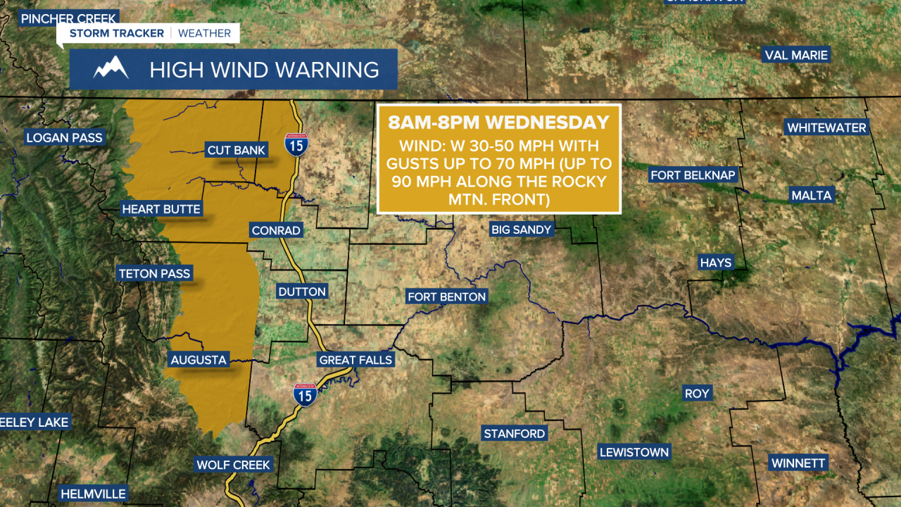
A HIGH WIND WARNING is in effect for the Rocky Mountain Front and adjacent locations from 8am until 8pm Wednesday.
A WINTER WEATHER ADVISORY is in effect for northeastern Montana from 4am Wednesday until 8pm Thursday.

A WINTER WEATHER ADVISORY is in effect for the Glacier area, the Rocky Mountain Front, and the Potomac/Seeley Lake region from 12am until 11am Wednesday.

A WINTER STORM WATCH is in effect for a lot of central and eastern Montana from Thursday afternoon through Saturday morning.

It was very windy last night and this morning, with hurricane-force wind gusts in some areas. 101 mph was the strongest wind gust recorded with this wind event, and it was recorded at Deep Creek in Glacier County, which is 8 miles east-southeast of East Glacier. This wind made for difficult travel conditions, especially for high-profile vehicles. There were at least three semis/trailers that were blown over in north-central Montana this morning, one along Highway 87 east of Stanford, one along I-15 north of Vaughn, and one along Highway 200 between Simms and Bowmans Corner.


The worst of the wind for today is now over with and the wind will continue to diminish through early tonight. The wind will then pick back up during the second half of the night, initially along the Rocky Mountain Front and then out across western portions of north-central Montana. Tomorrow will be extremely windy along the Rocky Mountain Front and out to I-15 as gusts up to 90 mph are possible right along the Rocky Mountain Front and gusts up to 70 mph are possible elsewhere. It is also going to be windy tomorrow along Highway 87/200, especially in Cascade County and Judith Basin County, as gusts up to 60 mph are possible. This wind will once again create difficult travel conditions for high-profile vehicles and vehicles pulling trailers, so those vehicles should avoid traveling tomorrow. Elsewhere, it will be breezy tomorrow with 10-25 mph sustained winds.

We are going to have increasing clouds tonight with some areas of snow and rain developing after midnight. Tomorrow, around the Helena area, there are going to be scattered rain and mountain snow showers around, generally during the morning. In north-central Montana, snow/rain showers are likely tomorrow in locations east of I-15 and along the Rocky Mountain Front/the Continental Divide, with snow switching over to rain as the day goes on as warmer air moves in. For those that see snow, light accumulations of up to an inch or two are possible. A light glaze of ice is also possible, with up to .1” of ice possible in northeastern Montana, which will make roads very slick. The mountains, especially in the Glacier area, may receive up to 7” of snow through tomorrow evening.
Here is the detailed forecast:
Tonight will be cooler than last night was as lows are going to be in the 20s and low to mid 30s in most locations (teens in northeastern Montana). Tomorrow will be another mild day as highs are going to be in the 40s and 50s in most locations (30s in northeastern Montana).
A strong, arctic cold front will push southward through north-central and central Montana on Thursday. Temperatures will start out in the 30s, 40s, and low 50s during the morning, but will fall into the teens and 20s by sunset. Precipitation will accompany this front. Initially, the precipitation will start out as rain, but this rain will switch-over to snow, and some of the snow that falls could be heavy at times. There are then going to be areas of light to moderate snow around Thursday night and Friday.
This will likely be a good snow event for north-central Montana as 2-8” of snow is expected for most, but up to a foot of snow is possible, with the highest snow amounts occurring east of I-15. In the mountains, over a foot of snow is possible. Around the Helena area, due to warmer air sticking around, less snow is expected as most locations will just receive less than 3” of snow. This snow will lead to difficult travel later Thursday through Saturday morning. A flash freeze is also possible on Thursday, especially along the Hi-Line where it will be raining Wednesday night, which could make the roads very icy.
Thursday will be a breezy day as sustained wind speeds are going to be between 10 and 25 mph, and wind gusts over 40 mph are possible. Friday will feature bitterly cold temperatures as highs are going to be in the 0s and 10s. The Helena area will miss this cool-down though as highs will remain in the 30s and low 40s.
Saturday will be another frigid day with highs in the -0s and 0s along the Hi-Line and the teens and low to mid 20s south of the Hi-Line. Helena will have pleasant temperatures again with highs in the 30s and low 40s. We are also going to have mostly cloudy skies on Saturday with a few lingering snow showers around during the morning, especially in the mountains.
Warmer air returns for Sunday and early next week as highs are going to be back in the 30s and 40s in most locations. A chinook wind is also expected on these three days as gusts over 60 mph are possible along the Rocky Mountain Front and gusts over 40 mph will be possible out across the plains. We are also going to have partly to mostly cloudy skies and mostly dry conditions on Sunday and Monday.


