A HIGH WIND WARNING is in effect for the Rocky Mountain Front and some adjacent locations from 2pm Friday until 12pm Saturday. Sustained wind speeds are going to be between 35 and 45 mph, and wind gusts up to 75 mph are possible.

We are going to have mostly clear skies and mainly dry conditions tonight. It is also going to be cool tonight as lows are going to be in the 20s and low to mid 30s in most locations. We are also going to have gusty winds around tonight along the Rocky Mountain Front as sustained wind speeds are going to be between 20 and 35 mph, and it is going to be breezy tonight in locations east of the Rocky Mountain Front as sustained wind speeds are going to be between 10 and 25 mph.
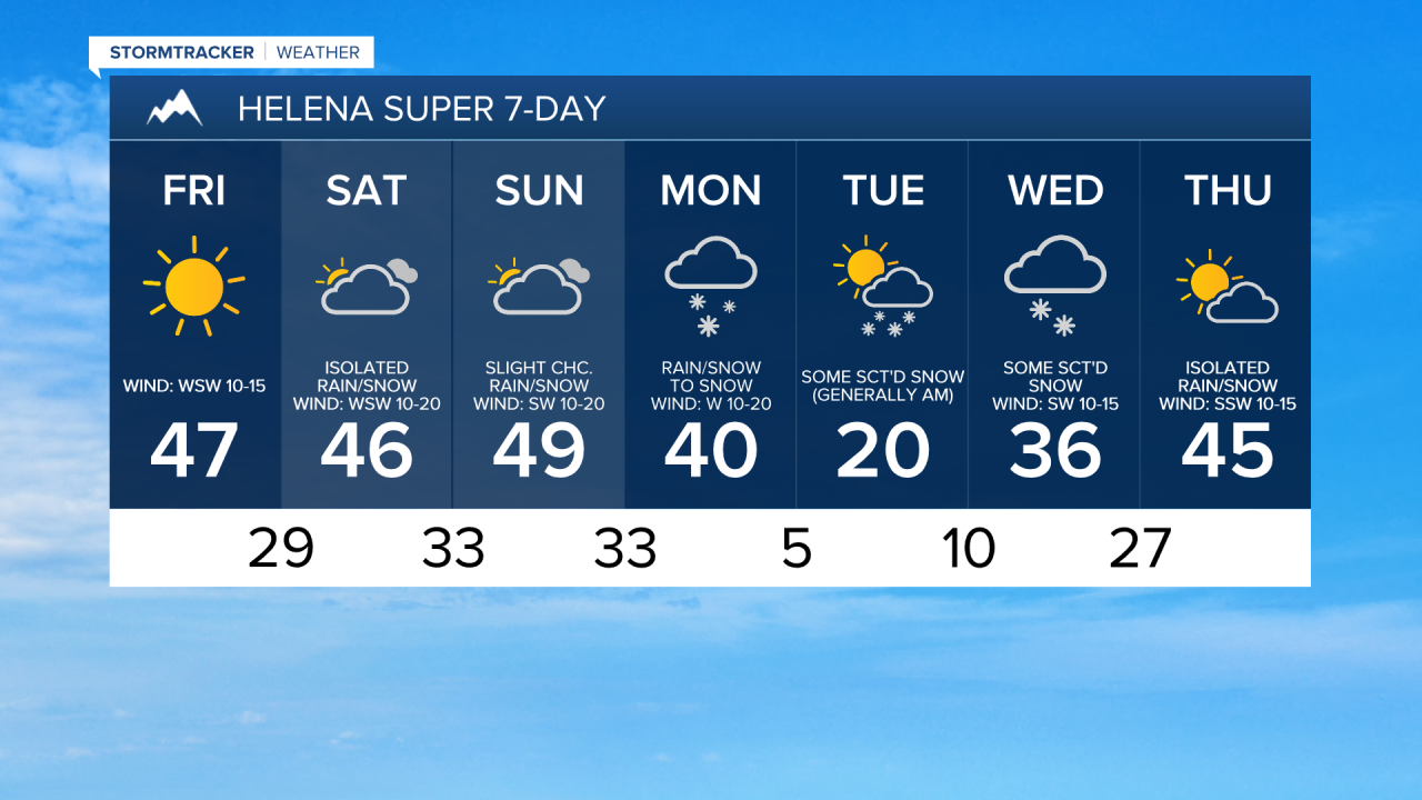
For tomorrow, we are going to have lots of sunshine, dry conditions, and mild temperatures as highs are going to be in the 40s and low 50s in most locations. It is also going to be very windy tomorrow along the Rocky Mountain Front as sustained wind speeds are going to be between 30 and 50 mph, and wind gusts over 70 mph are possible. East of the Rocky Mountain Front, we are going to have gusty winds around tomorrow as sustained wind speeds are going to be between 10 and 30 mph, and wind gusts over 40 mph are possible. Also, the wind tomorrow will be coming out of the west or the southwest in most locations.
On Saturday, we are going to have partly to mostly cloudy skies with a few scattered rain and snow showers around, generally in the mountains and in eastern portions of north-central Montana, as a disturbance passes through our area. We are also going to have gusty to strong winds around again on Saturday as wind gusts up to 60 mph are possible along the Rocky Mountain Front and wind gusts over 45 mph are possible in locations east of the Rocky Mountain Front. Also, the strongest wind on Saturday will be during the morning, with the wind decreasing some during the afternoon and evening. It is also going to be mild again on Saturday as highs are going to range from the upper 30s to the low 50s.
We are then going to have partly to mostly cloudy skies on Sunday with some rain and snow around, mainly in the mountains and along the Rocky Mountain Front, as a storm system begins to approach our area. East of the Rocky Mountain Front, mostly dry conditions are expected on Sunday. Sunday is also going to be one of the warmest days of the next week as highs are going to be in the 40s and low to mid 50s. It is also going to be extremely windy on Sunday along the Rocky Mountain Front as sustained wind speeds are going to be between 30 and 50 mph, and wind gusts over 65 mph are possible. East of the Rocky Mountain Front, it is also going to be windy on Sunday as sustained wind speeds are going to be between 15 and 35 mph, and wind gusts over 50 mph are possible. Also, the wind on Sunday will continue to come out of the west or southwest in most locations.
Nasty weather is then expected on Monday as a strong cold front passes through our area. There are going to be areas of precipitation around throughout the day, and this precipitation may be heavy at times, especially in the mountains. Precipitation will start out as rain in the lower elevations, but will switch-over to snow as colder air rushes into our area. Snow squalls are also possible on Monday, especially with the passage of the cold front.
It is also going to be windy on Monday as sustained wind speeds are going to be between 15 and 30 mph, and wind gusts over 40 mph are possible. The temperatures are also going to be falling throughout the day on Monday, from the 30s and 40s during the morning to the teens and 20s during the afternoon and evening. These falling temperatures may also cause a flash freeze to occur. Basically, Monday will be a great day to hang out at home if you can!
It is then going to be chilly on Tuesday as the temperatures are going to be in the 0s and -0s Tuesday morning and are only going to warm up into the teens and 20s during the afternoon. We are also going to have partly cloudy skies on Tuesday with a chance of snow, generally during the morning, as Monday’s storm system leaves our area. There is also going to be a little breeze around on Tuesday as sustained wind speeds are going to be between 5 and 20 mph.
A big warm up is then expected for the middle and end of next week as highs are going to be in the 30s and low to mid 40s on Wednesday and the 40s and low to mid 50s on Thursday. We are also going to have gusty to strong winds around on these two days as sustained wind speeds are going to be between 10 and 30 mph. A few scattered snow and rain showers are also possible on Wednesday, and a few isolated rain and snow showers are possible on Thursday as a couple disturbances work their way through our area. We are also going to have partly to mostly cloudy skies on these two days.