A WINTER WEATHER ADVISORY is in effect until 5am Wednesday for the Highwood Mountains and the Little Belt Mountains. Up to 7 inches of snow accumulation is possible. Blowing/drifting snow and reduced visibility is also expected as winds are going to be gusting as high as 45 mph.
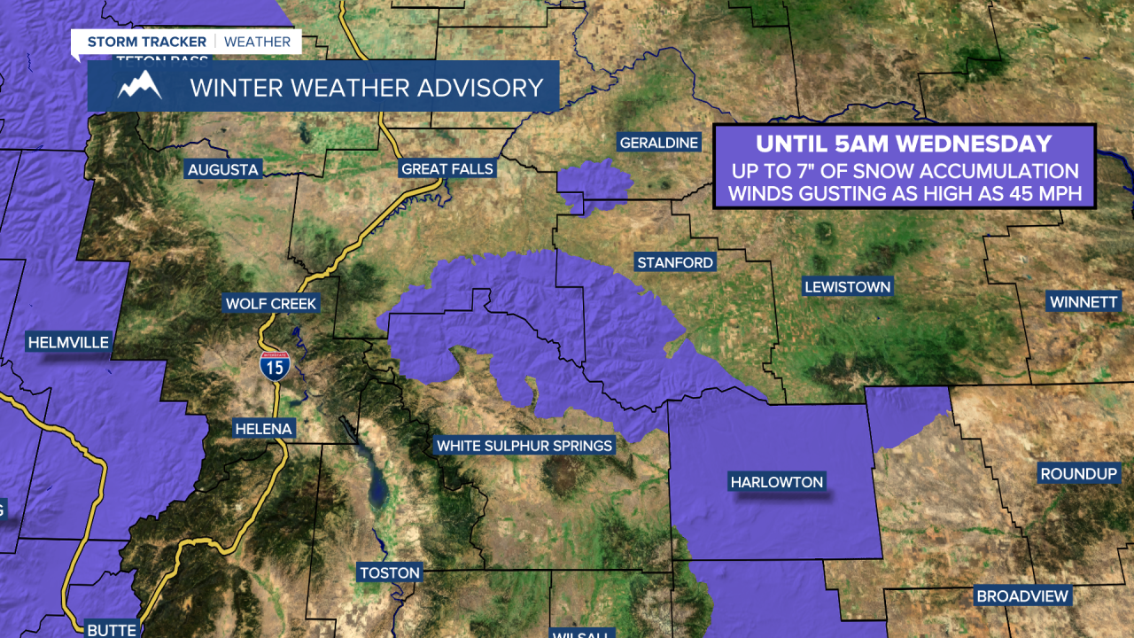
There are going to be a few snow showers around tonight, generally in the mountains and especially before midnight, as a disturbance passes through our area. Up to 7 inches of new snow accumulation is possible in the Little Belt and Highwood Mountains, with only light snow accumulations expected elsewhere. We are also going to have partly to mostly cloudy skies tonight. It is also going to be cold tonight in northeastern Montana as lows are going to be in the single digits above/below zero, and it is going to be chilly tonight everywhere else as lows are going to be in the teens and low to mid 20s.
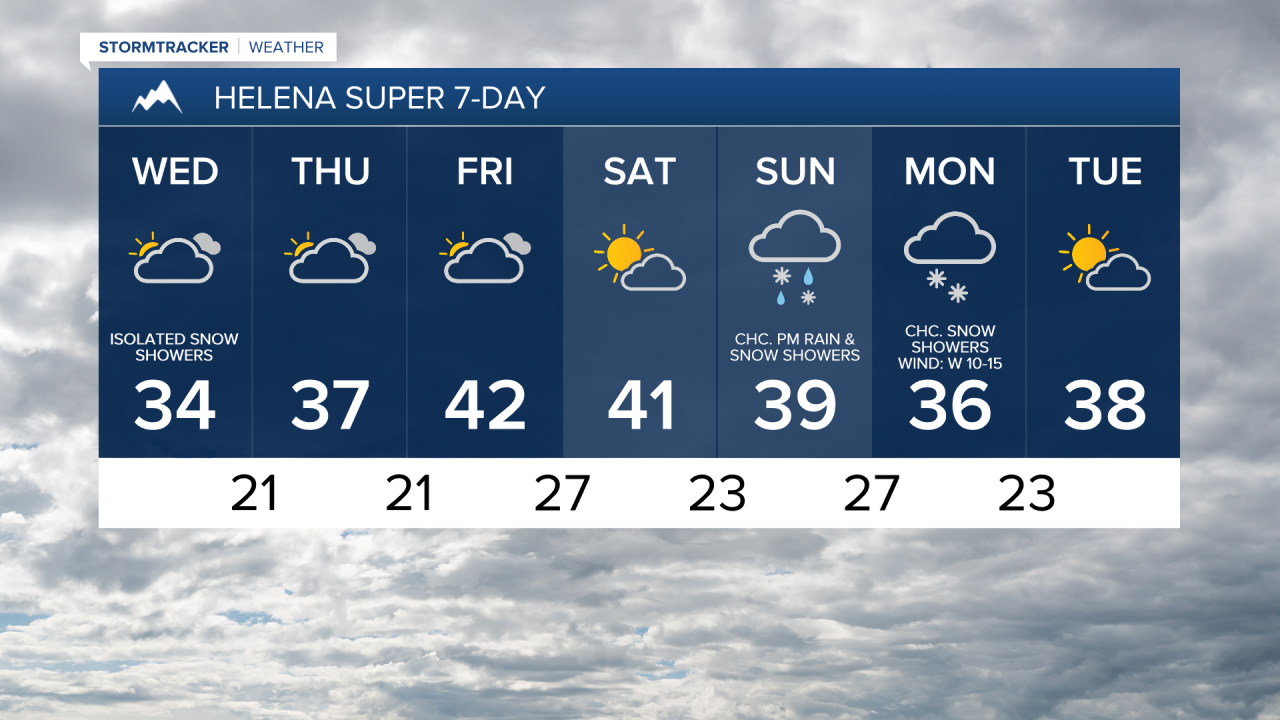
There are then going to be some scattered snow and rain showers around tomorrow and tomorrow night, generally between noon tomorrow and midnight tomorrow night and especially in locations east of I-15, as a disturbance passes through our area. In locations that do see some snow tomorrow and/or tomorrow night, light snow accumulations of a coating to an inch or two are possible in the lower elevations, with slightly higher amounts possible in the mountains. We are also going to have partly to mostly cloudy skies tomorrow. It is also going to be warmer tomorrow than it was today as highs are going to be in the 30s in most locations (20s in northeastern Montana).
We are also going to have gusty winds around tonight and tomorrow in some areas east of the Rocky Mountain Front as sustained wind speeds are going to be between 10 and 30 mph, and wind gusts over 40 mph are going to be possible at times. Along the Rocky Mountain Front, it is going to be windy tonight and tomorrow as sustained wind speeds are going to be between 20 and 40 mph, and wind gusts over 60 mph are going to be possible at times
On Thursday, we are going to have partly to mostly cloudy skies and mainly dry conditions. We are also going to have a wide range of high temperatures on Thursday as a cold front clips northeastern Montana as highs are going to range from the single digits to the low 40s. It is also going to be breezy in some areas on Thursday as sustained wind speeds are going to be between 10 and 20 mph.
Gusty winds are then expected on Friday and Saturday as sustained wind speeds are going to be between 10 and 30 mph, and wind gusts up to 50 mph are going to be possible at times. It is also going to be mild on these two days as highs are going to be in the 40s and mid to upper 30s in most locations. There are also going to be a few isolated rain and showers around on these two days as a disturbance passes through our area. We are also going to have mostly cloudy skies on Friday and partly cloudy to mostly sunny skies on Saturday.
On Sunday, we are going to have mostly cloudy skies with a chance of PM rain and snow showers, mainly around the Helena area, as a disturbance begins to approach our area. There are then going to be some scattered snow and rain showers around Sunday night and Monday as this disturbance passes through our area. The temperatures are also going to cool down a bit over these two days as highs are going to be in the mid to upper 30s and low to mid 40s on Sunday, and the 30s and low 40s on Monday. It is also going to be breezy on these two days as sustained wind speeds are going to be between 10 and 20 mph.