


A SEVERE THUNDERSTORM WATCH is in effect for a lot of eastern Montana as well as western North Dakota until 9pm Wednesday

There are going to be showers and thunderstorms around this evening and tonight (mainly before midnight) in eastern Montana and eastern portions of central Montana as a cold front continues to work its way through our area. A few severe thunderstorms with damaging winds (58+ mph) and/or large hail (1-2” in diameter) are also possible this evening and tonight. Elsewhere, we are going to have partly cloudy skies tonight with some isolated rain and mountain snow showers around.

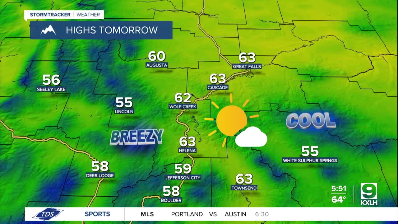
For tomorrow, we are going to have partly to mostly sunny skies with some scattered showers and thunderstorms around, generally in locations along the Hi-Line, as a disturbance clips our area. We are also going to have below average temperatures and gusty winds again tomorrow as highs are going to be in the mid to upper 50s and low to mid 60s and sustained wind speeds are going to be between 10 and 30 mph, and wind gusts over 40 mph are going to be possible at times.
On Friday, we are going to have to partly to mostly sunny skies with isolated showers and thunderstorms around, mainly along the Hi-Line. It is also going to be breezy on Friday as sustained wind speeds are going to be between 10 and 25 mph, and wind gusts up to 40 mph are possible. It is also going to be a bit warmer on Friday as highs are going to be in the mid to upper 60s and low 70s.
For this weekend, we are going to have partly to mostly cloudy skies with a few isolated showers and thunderstorms around. It is also going to be warm and a bit breezy this weekend as highs are going to be in the 70s and upper 60s in most locations and sustained wind speeds are going to be between 10 and 20 mph.
There are then going to be scattered showers and thunderstorms around on Monday, generally during the afternoon/evening, as a disturbance passes through our area. We are also going to have overcast skies on Monday. We are also going to have a wide range of temperatures on Monday as highs are going to range from the mid 60s to the mid 80s, with the warmest temperatures in northeastern Montana. It is also going to be breezy on Monday as sustained wind speeds are going to be between 10 and 25 mph.
Windy conditions are then expected on Tuesday and Wednesday as sustained wind speeds are going to be between 15 and 35 mph. The temperatures are also going to warm back up some over these two days as highs are going to be in the mid to upper 60s and low to mid 70s on Tuesday and the mid to upper 70s and low 80s on Wednesday. We are also going to have partly cloudy skies with a few isolated showers and thunderstorms around on Tuesday and mostly sunny skies and dry conditions on Wednesday.


