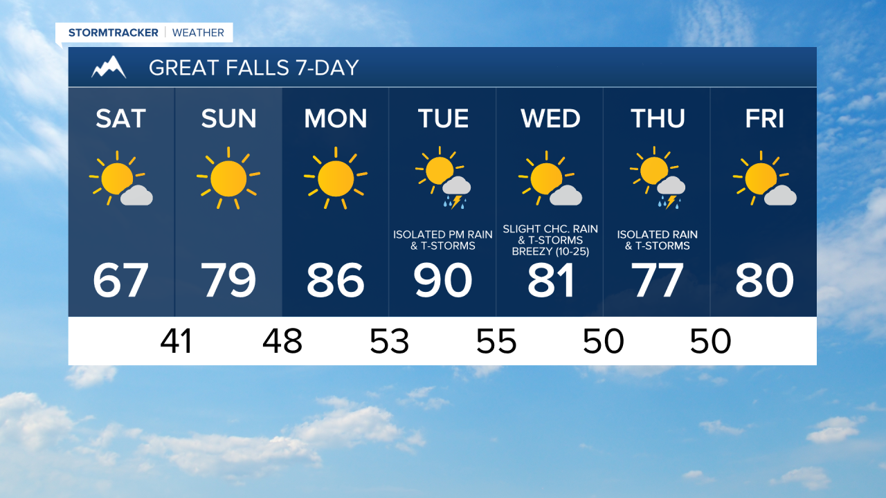
We are going to have decreasing clouds from west to east tonight with some isolated rain showers and thunderstorms around, generally before midnight. We are also going to have diminishing wind tonight in central Montana, and it is going to be breezy tonight in eastern Montana as sustained wind speeds are going to be between 10 and 25 mph. It is also going to be chilly/cool tonight as lows are going to be in the mid to upper 30s and low to mid 40s in most locations. Some frost is also possible tonight in a few lower elevation locations, so make sure you protect any sensitive plants that you may have.
For tomorrow, we are going to have partly cloudy to mostly sunny skies and cool, but comfortable temperatures as highs are going to be in the mid to upper 60s and low 70s. It is also going to be breezy tomorrow in eastern Montana as sustained wind speeds are going to be between 10 and 25 mph, and it is going to be a bit breezy tomorrow in eastern portions of north-central Montana as sustained wind speeds are going to be between 10 and 20 mph. For everyone else, there is just going to be a light breeze around tomorrow. Most locations are also going to be dry tomorrow, but some isolated showers and thunderstorms are expected along the eastern half of the Hi-Line (east of Havre).
We are then going to have fantastic weather on Sunday and Monday as we are going to have lots of sunshine, dry conditions, and not much wind as sustained wind speeds are generally going to be between 5 and 15 mph. The temperatures are also going to warm up a lot over these two days as highs are going to be in the mid to upper 70s and low 80s on Sunday, and the mid to upper 80s and low 90s on Monday.
Some isolated rain showers and thunderstorms are then possible Tuesday afternoon and evening as a disturbance passes through our area. We are also going to have increasing clouds on Tuesday. It is also going to be hot and a little breezy on Tuesday as highs are going to be in the upper 80s and low to mid 90s, and sustained wind speeds are going to be between 10 and 15 mph.
On Wednesday, we are going to have mostly sunny skies, mainly dry conditions, and cooler temperatures as highs are going to be in the upper 70s and low to mid 80s. It is also going to be breezy on Wednesday as sustained wind speeds are going to be between 10 and 25 mph, and wind gusts over 40 mph are going to be possible at times.
There are then going to be some more isolated rain showers and thunderstorms around on Thursday as another disturbance passes through our area. We are also going to have partly cloudy to mostly sunny skies and seasonable temperatures on Thursday as highs are going to be in the mid to upper 70s and low 80s. There is also going to be a little bit of a breeze around on Thursday as sustained wind speeds are going to be between 10 and 15 mph.