We are going to have partly cloudy to mostly clear skies tonight with a few isolated showers around in north-central Montana as a cold front passes through our area. It is also going to be cooler tonight than it was last night as lows are going to be in the 40s and low to mid 50s. There is also going to be a breeze around for a few hours tonight when the cold front passes through as sustained wind speeds are going to be between 10 and 20 mph.
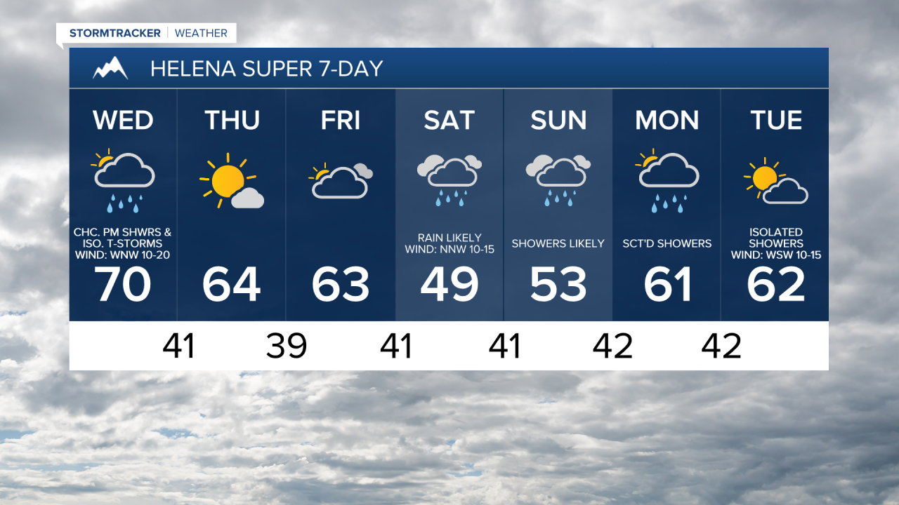
For tomorrow, we are going to have increasing clouds with scattered showers and isolated thunderstorms around during the afternoon and evening, especially in north-central Montana, as a disturbance passes through our area. It is also going to be breezy tomorrow afternoon/evening along the Rocky Mountain Front and in central Montana as sustained wind speeds are going to be between 10 and 25 mph. The temperatures are also going to be cooler tomorrow than they were today as highs are going to be in the mid to upper 60s and low to mid 70s in most locations.
Pleasant weather is then expected on Thursday as we are going to have mostly sunny skies, mainly dry conditions, and cool temperatures as highs are going to be in the 60s in most locations. It is also going to be breezy on Thursday as sustained wind speeds are going to be between 10 and 20 mph.
On Friday, we are going to have partly to mostly cloudy skies with a slight chance of showers as a large storm system begins to approach our area. It is also going to be cool again on Friday as highs are going to be in the 60s and upper 50s.
Cooler and wetter weather is then expected this weekend as an upper-level trough is going to be in control of our weather. Rain is likely on Saturday, and there are going to be scattered showers around on Sunday. Some mountain snow is also expected this weekend, with snow levels getting at least as low as 7000 feet. We are also going to have overcast skies and well below average temperatures this weekend as highs are going to range from the mid 40s to the mid 60s. It is also going to be a bit breezy this weekend as sustained wind speeds are going to be between 10 and 20 mph.
On Monday, there are going to be scattered showers around, especially during the morning, as this weekend’s storm system leaves our area. We are also going to have partly to mostly cloudy skies and warmer temperatures on Monday as highs are going to be in the mid to upper 50s and low to mid 60s in most locations. It is also going to be breezy on Monday as sustained wind speeds are going to be between 10 and 20 mph.
We are then going to have partly cloudy skies on Tuesday with some isolated showers around as another disturbance approaches our area. It is also going to be cool and breezy on Tuesday as highs are going to be in the 60s and sustained wind speeds are going to be between 10 and 20 mph.