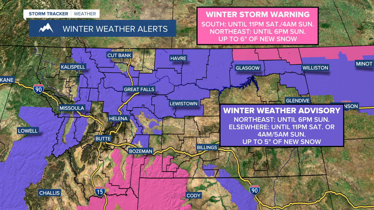
A WINTER STORM WARNING is in effect for portions of southern Montana until 11pm Saturday/4am Sunday and for portions of northeastern Montana until 6pm Sunday. Up to 6 inches of new snow accumulation is possible.
A WINTER WEATHER ADVISORY is in effect for portions of northeastern Montana until 6pm Sunday and for most of north-central Motnana and portions of western and southern Montana until 11pm Saturday or 4am/5am Sunday. Up to 5 inches of new snow accumulation is possible.
There are going to continue to be areas of snow around this evening and tonight, especially before midnight and especially in locations east of I-15. Some of this snow may also be heavy at times. An additional 1 to 6 inches of snow accumulation is expected along central and eastern portions of the Hi-Line, while less than 4 inches of new snow accumulation is expected elsewhere. Roads are also going to be slick/snow-covered in a lot of areas tonight, so please use extreme caution when driving and give yourself some extra time to get to where you need to go.

To go along with the snow, it is also going to be cold and breezy tonight as lows are going to be in the single digits and teens and sustained wind speeds are going to be between 10 and 25 mph. Subzero wind chills are also expected in a lot of locations tonight.
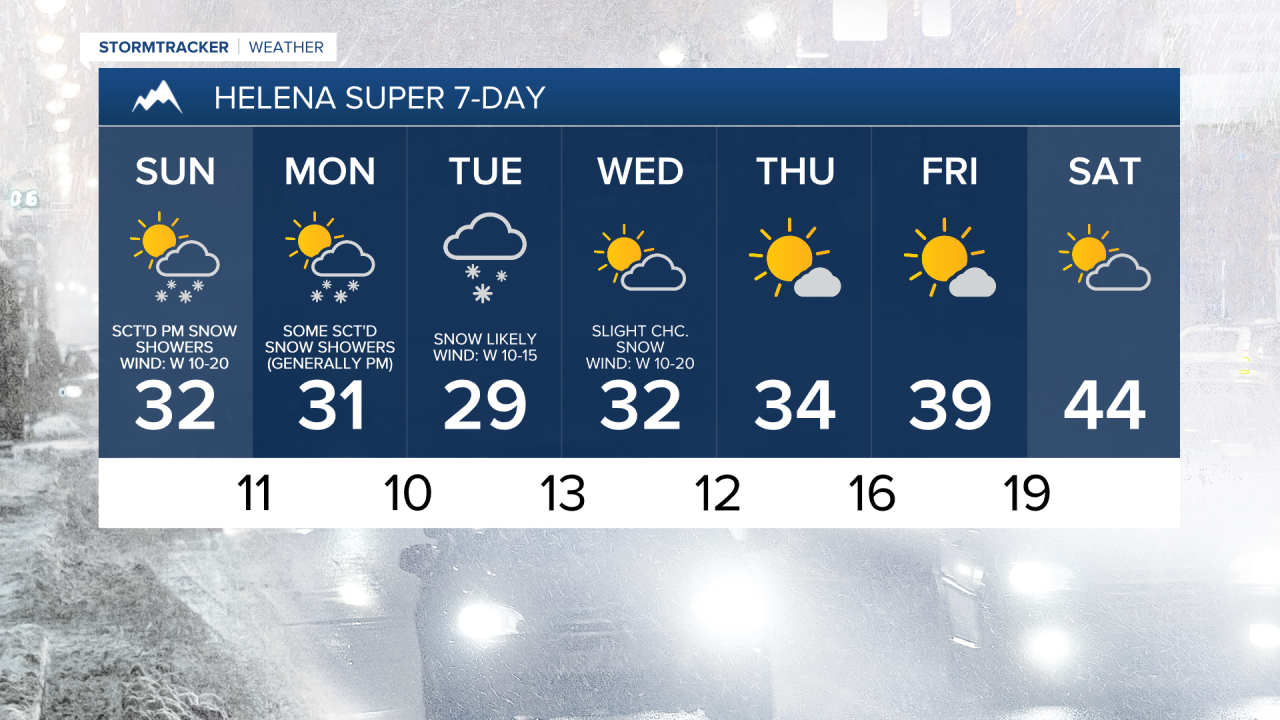
For tomorrow, we are going to have partly cloudy skies with some snow showers around in northeastern Montana during the morning and some scattered snow showers around in central and north-central Montana during the afternoon/evening. New snow accumulation of up to an inch or two is possible in locations that do see some snow during the day tomorrow. It is also going to be cold tomorrow as highs are going to be in the teens and low to mid 20s in north-central Montana and the mid to upper 20s and low 30s around Helena. There is also going to be a good breeze around tomorrow (especially in locations east of I-15) as sustained wind speeds are going to be between 10 and 25 mph, and this wind will cause the wind chills to be below zero at times.
On Monday, we are going to have partly cloudy skies with some scattered snow showers around, generally during the afternoon/evening and especially in the mountains. It is also going to be cold and a little breezy on Monday as highs are going to be in the 20s and mid to upper teens and sustained wind speeds are going to be between 5 and 20 mph.
There are then going to be areas of snow around on Tuesday as another disturbance passes through our area. We are also going to have mostly cloudy skies and below average temperatures on Tuesday as highs are going to be in the 20s and mid to upper teens.
On Wednesday, we are going to have partly cloudy skies with a slight chance of snow showers. Mostly sunny skies and mostly dry conditions are then expected on Thursday, Friday, and Saturday as high pressure is going to be in control of our weather. The temperatures are also going to warm back up over these four days as highs are going to be in the 20s and low to mid 30s on Wednesday; the 30s and mid to upper 20s on Thursday; the 30s and low to mid 40s on Friday; and the 40s and low to mid 50s on Saturday. It is also going to be breezy in some areas on these four days as sustained wind speeds are going to be between 10 and 20 mph, with stronger wind possible on Saturday.