


A WINTER STORM WARNING is in effect for locations above 5000 feet in Cascade County, Jefferson County, Judith Basin County, central and southern Lewis and Clark County, and Meagher County until 12am Saturday. 6 to 12+ inches of snow accumulation is expected in the mountains, and little to no snow accumulation is expected below 4000 feet.
A WINTER WEATHER ADVISORY is in effect for the Rocky Mountain Front until 6pm Friday. 2 to 5 inches of snow accumulation is expected above 5000 feet.

Precipitation is going to become more widespread in coverage as we go through tonight as a storm system begins to impact our area. There are then going to be areas of precipitation around throughout the day tomorrow as this storm system works its way through our area. For tonight and tomorrow, primarily rain is expected in the lower elevations, but some lower elevation locations will see some snow late tonight/tomorrow morning as snow levels drop down to about 3500 feet. In the mountains, all snow is expected tonight and tomorrow.
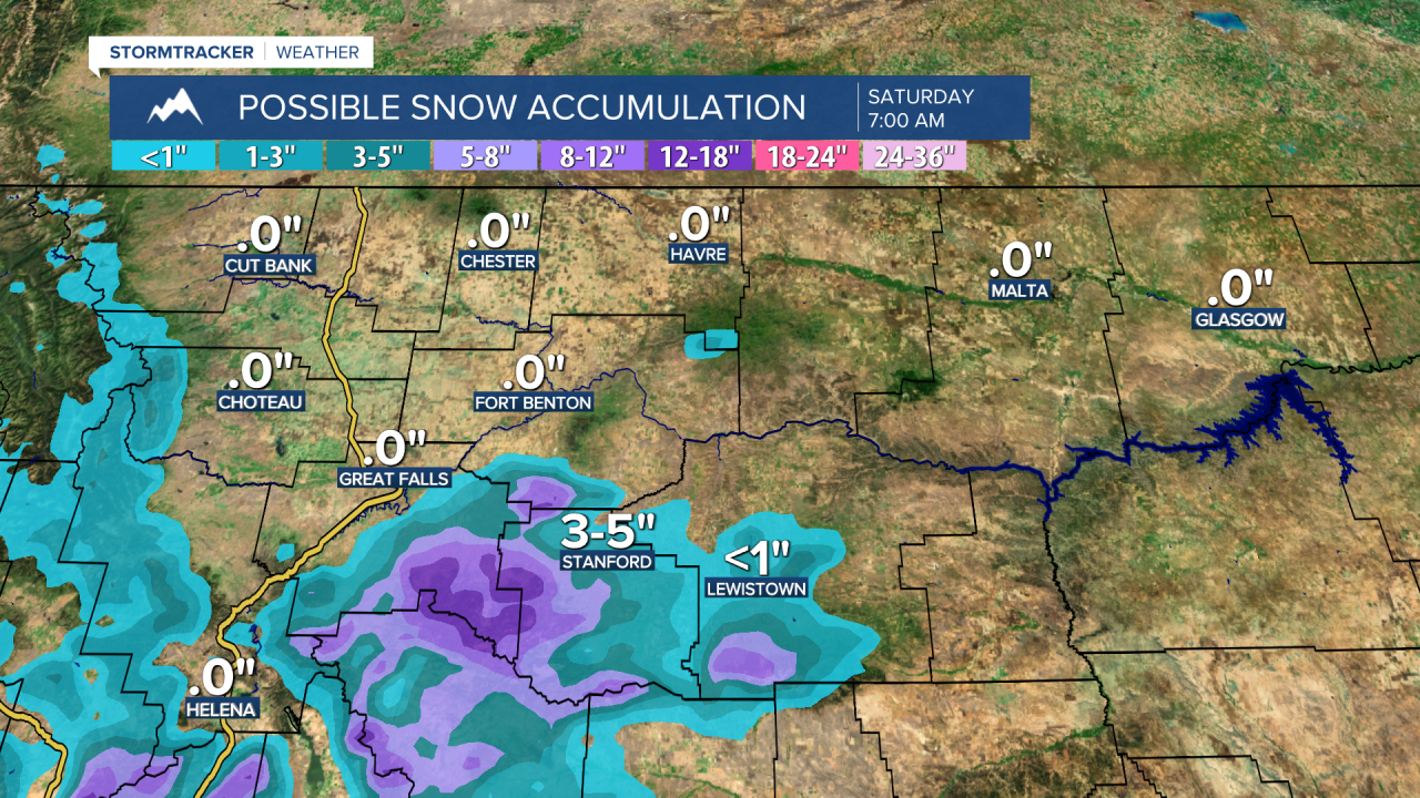
Between this evening and Saturday morning, 2 to 5 inches of snow accumulation is expected along the Rocky Mountain Front above 5000 feet; 6-12+ inches of snow accumulation is expected in the mountains (above 5000 feet) in central Montana; and little to no snow accumulation is expected in most other locations, although a few spots may receive light snow accumulations of a couple inches.

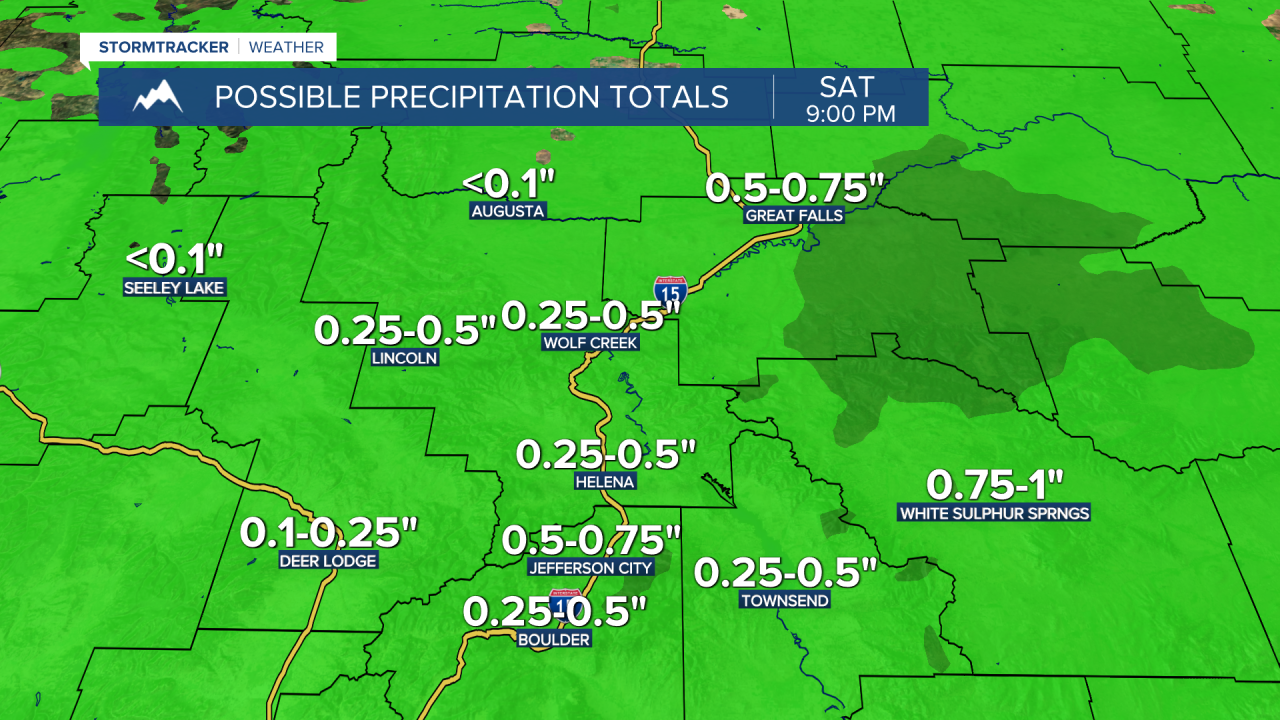
Now in terms of precipitation between this evening and Saturday morning, up to 0.25” of precipitation is possible along the Hi-Line and along the Rocky Mountain Front, but many locations are probably going to receive less than 0.1” of precipitation. In the mountains in central Montana and in the northerly upslope regions of these mountains, including Great Falls, 0.5” to 1.5” of precipitation is expected. In the valleys and in all other locations, generally 0.25” to 0.75” of precipitation is expected.

For tonight, we are going to have cool temperatures as lows are going to be in the 30s and low to mid 40s. For tomorrow, highs are going to be in the mid to upper 40s and low to mid 50s in most locations, with the warmest temperatures expected along the Hi-Line. There is also going to be a bit of a breeze around tomorrow as sustained wind speeds are going to be between 5 and 20 mph.
On Saturday, we are going to have increasing clouds with a chance of evening rain and mountain snow showers, generally in south-central Montana, as the next storm system begins to approach our area. There are then going to be some scattered rain and mountain snow showers around on Sunday, generally in the higher elevations, as this storm system leaves our area. We are also going to have mostly cloudy skies on Sunday. It is also going to be cool this weekend as highs are going to be in the 50s in a lot of locations. There is also going to be a little bit of a breeze around on Sunday as sustained wind speeds are going to be between 5 and 20 mph.
We are then going to have increasing clouds with a chance of evening rain and mountain snow showers on Monday as the next storm system begins to approach our area. There are then going to be some scattered rain and mountain snow showers around Monday night and Tuesday as this storm system passes through our area. The temperatures are also going to cool down some over these two days as highs on Monday are going to be in the upper 50s and low to mid 60s, and highs on Tuesday are going to be in the upper 40s and low to mid 50s. It is also going to be a bit breezy on Tuesday as sustained wind speeds are going to be between 10 and 20 mph.
Mostly to mainly sunny skies and dry conditions are then expected on Wednesday and Thursday as high pressure is going to be in control of our weather. The temperatures are also going to warm up a lot over these two days as highs are going to be in the low to mid 60s on Wednesday, and the upper 60s and low to mid 70s on Thursday.


