


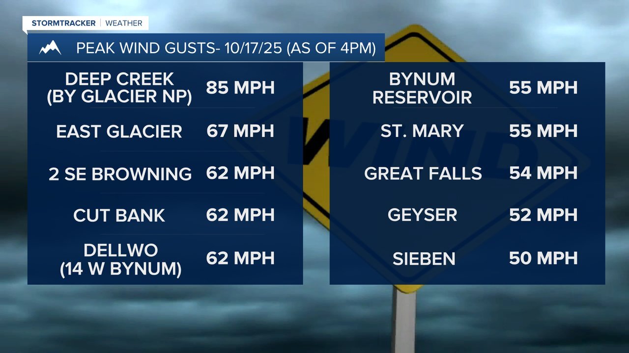
It's been a windy Friday! Peak wind gusts topped 60 mph along the Rocky Mountain Front and in portions of Glacier County, with Deep Creek near East Glacier recording a gust of 85 mph! Even portions of the plains saw strong winds today with Great Falls recording a gust of 54 mph and Geyser recording a gust of 52 mph!
Today started off dry, but there have been scattered rain and mountain snow showers around this afternoon and evening, and there will continue to be scattered rain and mountain snow showers around for the rest of this evening and tonight, generally before midnight, as a disturbance passes through our area. A brief changeover to snow will also be possible in some lower elevation locations, although little to no snow accumulation is expected. In the mountains, up to 4” of snow is possible tonight.
It is also going to be a bit chilly tonight as lows are going to be in the mid to upper 20s and low to mid 30s in most locations. The wind will also die down this evening and early tonight, with just a little breeze around after midnight.
Here is the detailed forecast:
Tomorrow will be a beautiful day with mostly sunny skies, dry conditions, and pleasant temperatures as highs are going to be in the 50s in most locations. It is also going to be breezy tomorrow as sustained wind speeds are going to be between 10 and 25 mph, with the strongest wind along the Rocky Mountain Front and in northeastern Montana.
As we go through tomorrow night, the wind will increase once again as another storm system begins to impact the state. Late tomorrow night and Sunday, it is going to be very windy along the Rocky Mountain Front and along the western half of the Hi-Line as sustained wind speeds are going to be between 25 and 45 mph, and wind gusts between 65 and 75 mph are possible. This strong wind has prompted the National Weather Service to issue a HIGH WIND WATCH for the Rocky Mountain Front, the eastern half of Glacier County, Liberty County, and Toole County from 12am/4am until 8pm Sunday. This wind will make travel difficult for high-profile vehicles, especially on north-south oriented roads, as the wind will be coming out of the west/southwest.

In north-central Montana east of the Rocky Mountain Front, it is going to be windy on Sunday as sustained wind speeds are going to be between 15 and 35 mph, and wind gusts over 50 mph are possible. In northeastern Montana, it is going to be breezy later in the day on Sunday as sustained wind speeds are going to be between 10 and 25 mph, and wind gusts up to 40 mph are possible.
Wetter weather is also expected on Sunday as rain and mountain snow showers are likely around Helena, especially during the morning, and there are going to be some scattered rain and mountain snow showers around in north-central Montana, especially during the morning. We will also start off Sunday with overcast skies, but the cloud cover will diminish some from west to east as we head into the afternoon and evening.
In the higher terrain in Glacier National Park, 3-8” of snow is expected on Sunday. In the other mountain ranges within central and north-central Montana, up to 3” of snow is possible on Sunday. In the lower elevations, no snow is expected on Sunday. We are also going to have a wide range of temperatures on Sunday as highs are going to range from the mid 40s to the mid 60s, with the coolest temperatures along the Rocky Mountain Front.

On Monday, there are going to continue to be a few scattered rain and mountain snow showers around, generally during the morning and generally in the mountains and in locations east of I-15, as Sunday’s storm system leaves our area. It is also going to be breezy and cooler on Monday as sustained wind speeds are going to be between 10 and 25 mph, and highs are going to be in the mid to upper 40s and low to mid 50s.
Nice weather is then expected for the rest of next week as we are going to have partly cloudy skies, dry conditions, and warming temperatures. On Tuesday and Wednesday, highs are going to be in the mid to upper 50s and low to mid 60s. Highs are then going to be in the 60s and low 70s on Thursday and Friday. There is also going to be a breeze around in some areas all of next week as sustained wind speeds are going to be between 10 and 25 mph.


