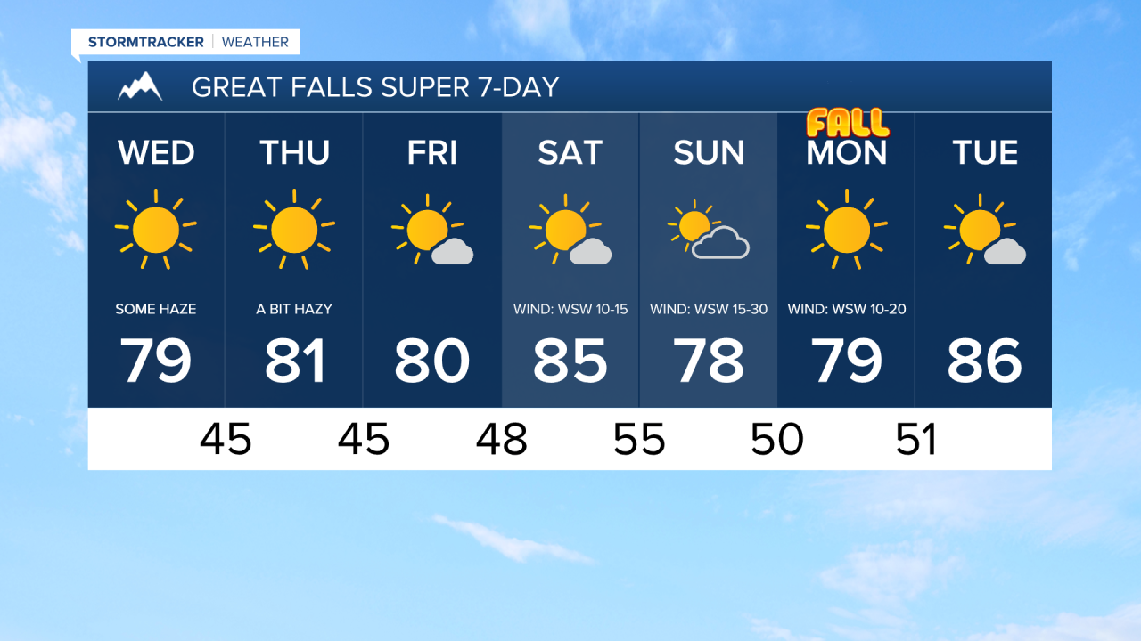
It has been hazy today and there will continue to be some haze around tonight and tomorrow. This haze will reduce the visibility some and will cause minor impacts to the air quality as the air quality will be in the “moderate” category at times. The haze will then diminish some as we head into Thursday.
There will be some isolated showers and thunderstorms around this evening and early tonight, but most locations will be dry. We are also going to have decreasing clouds this evening and tonight, with mainly clear skies expected after midnight. It is also going to feel nice outside tonight as lows are going to be in the 40s and low 50s in most locations.
Here is the detailed forecast:
An upper-level ridge will build into our area tomorrow and will remain in control of our weather through Saturday. This means we are going to have beautiful weather for the next several days. Tomorrow and Thursday will feature lots of sunshine, and Friday and Saturday will feature mostly sunny skies. It is also going to be mainly dry through Saturday; just a few isolated showers/storms in northeastern Montana on Thursday and a few isolated showers/storms in/around the mountains on Friday and Saturday.
We are also going to have above average temperatures from Wednesday through Saturday as highs are going to be in the mid to upper 70s and low to mid 80s in most locations. There will be little to no wind tomorrow and Friday. On Thursday, it will be a little breezy along the eastern half of the Hi-Line as sustained wind speeds are going to be between 5 and 20 mph. On Saturday, it will be a bit breezy in western portions of north-central Montana as sustained wind speeds are going to be between 10 and 20 mph.
A cold front will pass through the state on Sunday. The biggest impact from this cold front is going to be the wind as gusty winds are expected. Sustained wind speeds on Sunday are going to be between 10 and 30 mph, and gusts over 40 mph are possible across the plains. Along the Rocky Mountain Front, gusts over 50 mph are possible. It is also going to be cloudier on Sunday as it will be partly cloudy, and although a lot of locations will remain dry, there will be isolated showers and thunderstorms around, generally in/around the mountains. This cold front will also cool the temperatures down a few degrees as highs are going to be in the 70s and low 80s.
Monday is the First Day of Fall, and we are going to have spectacular weather to welcome in the new season. Monday will be a mainly sunny and dry day as an upper-level ridge begins to build back into our area. It is also going to be mild and breezy on Monday as highs are going to be in the mid to upper 70s and low 80s, and sustained wind speeds are going to be between 10 and 20 mph.
The ridge strengthens on Tuesday, so it will be very warm for this time of year as highs are going to be in the 80s. We are also going to have mostly sunny skies on Tuesday.