A WINTER STORM WARNING is in effect for the East Glacier area from 12am Wednesday until 12pm Thursday.
A WINTER WEATHER ADVISORY is in effect for the northern High Plains and the southern Rocky Mountain Front from 12am Wednesday until 12pm Thursday.
A WINTER STORM WATCH is in effect for the Highwood and Little Belt mountains from 6am Wednesday until 12pm Thursday.

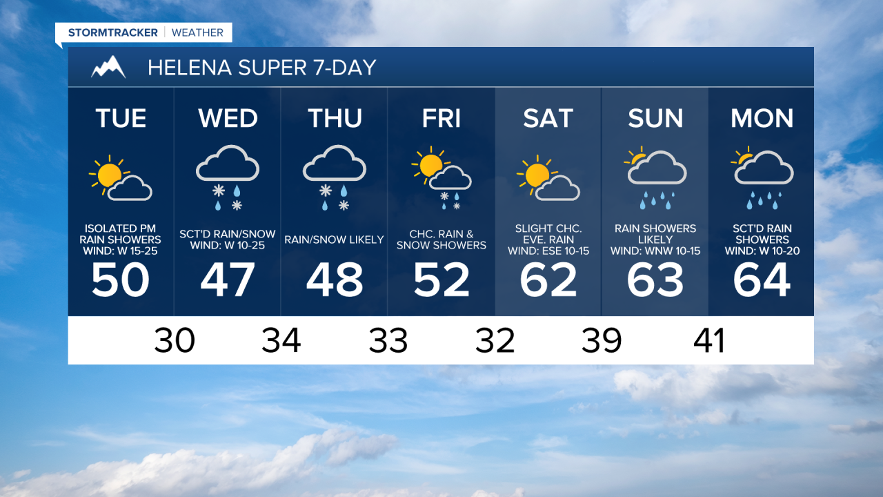
There are going to be scattered rain and mountain snow showers around this evening and tonight, generally in locations east of I-15, as a disturbance works its way through our area. It is also going to be breezy and chilly tonight as sustained wind speeds are going to be between 10 and 20 mph, and lows are going to be in the 30s and upper 20s in most locations. Along the Rocky Mountain Front, gusty winds are expected tonight as sustained wind speeds are going to be between 15 and 30 mph.
For tomorrow, we are going to have partly cloudy skies with some scattered rain and snow showers around, generally along the Hi-Line and in the mountains. Widespread gusty winds are also expected tomorrow as sustained wind speeds are going to be between 10 and 30 mph, and wind gusts over 40 mph are possible. Along the Rocky Mountain Front, it is going to be windy tomorrow as sustained wind speeds are going to be between 20 and 35 mph, and wind gusts over 50 mph are possible. It is also going to be cool/chilly tomorrow as highs are going to be in the mid to upper 40s and low to mid 50s in most locations.
There are then going to be areas of precipitation around on Wednesday and Thursday as a storm system works its way through our area. In the mountains, this precipitation will be in the form of snow. In the lower elevations, this precipitation will be in the form of rain and snow, with a better chance at seeing snow during the overnight and morning hours, and a better chance at seeing rain during the afternoon and evening. We are also going to have mostly cloudy to overcast skies on these two days.
Between Monday evening and Thursday evening, most locations in north-central and central Montana will receive between .25” and 1” of precipitation, with this precipitation coming in the form of both rain and snow.

In the mountains, 5-12” of snow accumulation is possible through Thursday evening, with up to 18” of snow accumulation possible in the higher terrain in Glacier National Park. In the lower elevations, most locations will receive less than 2” of snow (with most of that accumulation occurring on grassy surfaces), but up to 6” of snow accumulation is possible, mainly in lower elevation locations that are along northern portions of the Rocky Mountain Front, near the Canadian border in Glacier County, or are near the Little Belt and Snowy Mountains.

It is also going to be chilly on Wednesday and Thursday as highs are going to range from the mid 30s to the mid 50s, with the warmest temperatures in northeastern Montana. We are also going to have widespread gusty winds around again on Wednesday as sustained wind speeds are going to be between 10 and 25 mph, and wind gusts up to 40 mph are possible. It is then going to be breezy on Thursday as sustained wind speeds are going to be between 10 and 20 mph.
On Friday, we are going to have partly to mostly cloudy skies with scattered rain and snow showers around, generally in locations east of I-15 and especially during the morning. It is also going to be chilly/cool and a little breezy on Friday as highs are going to be in the mid to upper 40s and low to mid 50s, and sustained wind speeds are going to be between 5 and 20 mph.
Saturday is then going to be the nicest day of the next week as we are going to have partly to mostly sunny skies, mainly dry conditions, just a little breeze (sustained wind speeds between 5 and 20 mph), and warmer temperatures as highs are going to be in the mid to upper 50s and low to mid 60s.
There are then going to be scattered rain showers around Helena on Sunday and Monday and we are going to have a chance to see some rain showers in north-central Montana on Sunday and Monday as a couple more disturbances impact our area. We are also going to have pleasant temperatures on these two days as highs are going to be in the 60s and upper 50s in most locations. It is also going to be breezy on Monday as sustained wind speeds are going to be between 10 and 20 mph.