A HIGH WIND WATCH is in effect for the Rocky Mountain Front and the adjacent plains from 12am until 5pm Saturday. Sustained wind speeds are going to be between 20 and 40 mph, and wind gusts over 60 mph are possible.

A WINTER WEATHER ADVISORY is in effect for portions of western Montana, including Glacier National Park, from 11am/5pm Friday until 11am/5pm/6pm Saturday. 2 to 6 inches of snow accumulation is expected in the lower elevations, and 6 to 18 inches of snow accumulation is expected in the mountains. Winds are also going to be gusting as high as 40 mph, which means that blowing snow and reduced visibility will also be an issue.
A WINTER STORM WARNING is in effect for portions of western Montana and northern Idaho from 5pm Friday until 5pm Saturday. 1 to 4 inches of snow accumulation is expected in the lower elevations, and 4 to 15 inches of snow accumulation is expected in the mountains. Winds are also going to be gusting as high as 35 mph, which means that blowing snow and reduced visibility will also be an issue.

We are going to have mostly cloudy skies tonight with just a couple isolated snow showers around in the mountains. It is also going to be chilly again tonight as lows are going to be in the mid to upper teens and low 20s in most locations. The wind is also going to begin to pick up later on tonight along the Rocky Mountain Front.
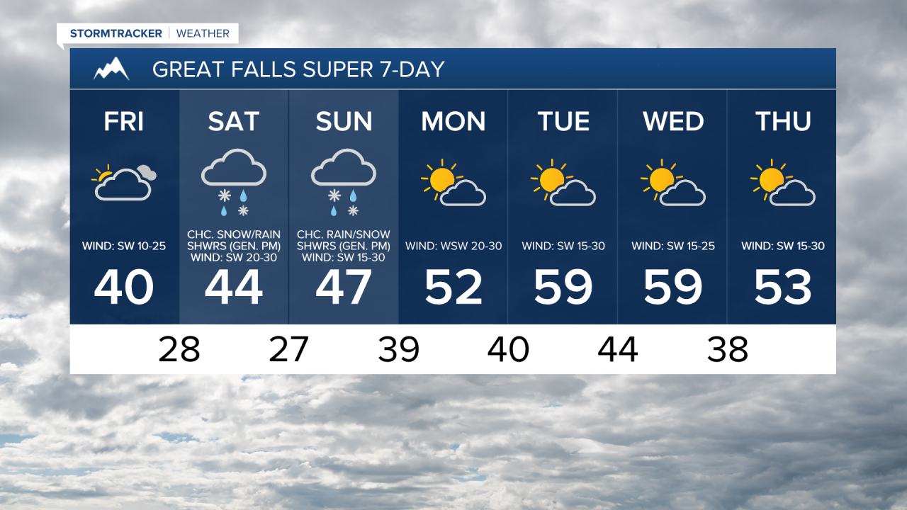
For tomorrow, we are going to have mostly to partly cloudy skies with a few isolated snow showers around in north-central Montana (generally in the mountains) and some scattered snow showers around the Helena area (generally in the mountains). It is also going to be slightly warmer tomorrow than it was today as highs are going to be in the mid to upper 30s and low 40s. There is also going to be a breeze around tomorrow along/just east of the Rocky Mountain Front and around the Great Falls area as sustained wind speeds are going to be between 10 and 25 mph.
Snow is then likely on Saturday along and west of the Continental Divide; there are going to be snow showers around on Saturday around the Helena area (especially in the mountains and generally during the afternoon/evening); and there are going to be some scattered rain and snow showers around on Saturday in north-central Montana (especially in the mountains and generally during the afternoon/evening) as a cold front passes through our area.
We are also going to have partly to mostly cloudy skies and seasonable temperatures on Saturday as highs are going to be in the upper 30s and low to mid 40s. It is also going to be very windy on Saturday along the Rocky Mountain Front as wind gusts over 60 mph are possible, and it is going to be gusty on Saturday in locations east of the Rocky Mountain Front as wind gusts over 40 mph are possible.
On Sunday, a mix of snow and rain is likely along and west of the Continental Divide; rain and snow showers are likely around the Helena area (especially in the mountains and generally during the afternoon/evening); and there are going to be some scattered rain and snow showers around in north-central Montana (especially in the mountains and generally during the afternoon/evening) as another disturbance begins to pass through our area. There are then going to be some isolated rain and snow showers around on Monday, generally in the mountains, as this disturbance leaves our area. We are also going to have partly to mostly cloudy skies on these two days.
The temperatures are also going to warm up a little bit over these two days as highs are going to be in the upper 30s and low to mid 40s on Sunday, and the mid to upper 40s and low 50s on Monday. We are also going to have increasing wind on Sunday, with windy conditions developing along the Rocky Mountain Front (gusts over 60 mph are possible) and gusty winds developing in some areas east of the Rocky Mountain Front (gusts over 40 mph are possible). It is then going to be very windy on Monday as sustained wind speeds are going to be between 15 and 35 mph, and wind gusts over 50 mph are possible, with even stronger wind expected along the Rocky Mountain Front.
We are then going to have partly to mostly cloudy skies, mostly dry conditions, and mild temperatures on Tuesday and Wednesday as highs are going to be in the 50s and low 60s in most locations. We are also going to continue to have gusty to strong winds on these two days as sustained wind speeds are going to be between 15 and 30 mph, and wind gusts up to 50 mph are possible.
On Thursday, we are going to have partly cloudy skies with a slight chance of rain and snow showers in north-central Montana and a chance of rain and snow showers around the Helena area as the next disturbance begins to impact our area. We are also going to have gusty winds and cooler temperatures on Thursday as sustained wind speeds are going to be between 10 and 30 mph, and high temperatures are going to be in the mid to upper 40s and low to mid 50s in most locations.