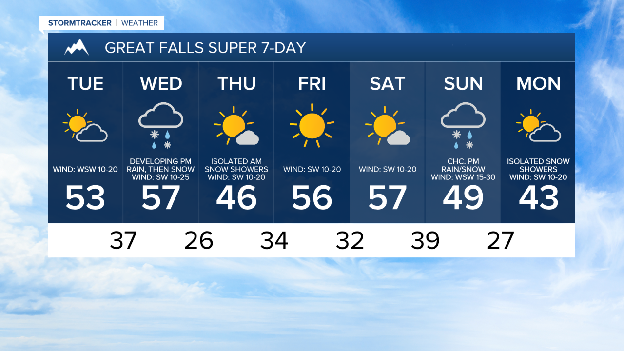
A WINTER WEATHER ADVISORY is in effect for the Glacier National Park area from 5am Wednesday until 5am/9am Thursday. 1 to 5 inches of snow accumulation is expected in the lower elevations, and 5 to 10+ inches of snow accumulation is expected at/above mountain pass level.

We are going to have partly cloudy to mostly clear skies tonight, with decreasing clouds during the first half of the night and increasing clouds during the second half of the night. Most locations are also going to be dry tonight, but there will be a little bit of snow along the Continental Divide before midnight. It is also going to be cool tonight as lows are going to be in the upper 20s and low to mid 30s. There is also going to be a breeze around tonight along the Rocky Mountain Front and along the Hi-Line as sustained wind speeds are going to be between 10 and 25 mph. Elsewhere, it is just going to be a little breezy tonight.
For tomorrow, we are going to have partly cloudy skies, with decreasing clouds during the afternoon/evening. Most locations are also going to be dry tomorrow, but some isolated rain and snow showers are possible, generally in central Montana. It is also going to be cooler tomorrow than it was today as highs are going to be in the mid to upper 40s and low to mid 50s. There is also going to be a breeze around tomorrow along the Rocky Mountain Front and in portions of the plains as sustained wind speeds are going to be between 10 and 25 mph.
On Wednesday, snow is likely throughout the day in the Rockies. East of the Rockies, we are going to have mostly cloudy skies on Wednesday with developing precipitation, generally during the afternoon/evening. Widespread precipitation is then likely Wednesday night. In the lower elevations, this precipitation is going to start out as rain, but this rain will mix in with and switch-over to all snow Wednesday evening/night. We are then going to have decreasing clouds on Thursday with some lingering snow showers during the morning in central Montana.
The highest snow amounts with this storm system are going to be in the Glacier National Park area, where 1 to 5 inches of snow accumulation is expected in the lower elevations, and 5 to 10+ inches of snow accumulation is expected at/above pass level. In the mountains in central Montana, up to 8 inches of snow accumulation is possible.
In the lower elevations in central and north-central Montana, this is going to be a minor snow event, as less than 3 inches of snow accumulation is expected. Also, with some snow and the temperatures dropping below freezing Wednesday night, plan for slick roads Thursday morning as you head to work and school.
It is also going to be breezy in some areas on Wednesday and Thursday as sustained wind speeds are going to be between 10 and 25 mph. The temperatures are also going to cool down some between these two days as highs on Wednesday are going to be in the upper 40s and low to mid 50s in most locations, and highs on Thursday are going to be in the upper 30s and low to mid 40s in most locations.
We are then going to have really nice weather on Friday and Saturday as high pressure is going to be in control of our weather. On Friday, we are going to have lots of sunshine, and on Saturday, we are going to have partly cloudy to mostly sunny skies. We are also going to have mild temperatures on these two days as highs are going to be in the 50s in most locations. There is also going to be a breeze around in some areas on these two days as sustained wind speeds are going to be between 10 and 20 mph.
On Sunday, we are going to have mostly cloudy skies with a chance of rain and snow, generally during the afternoon/evening, as a storm system begins to impact our area. We are then going to have partly cloudy skies on Monday with a chance of snow, generally during the morning, as this storm system leaves our area. The temperatures are also going to cool down some over these two days as highs are going to be in the mid to upper 40s and low to mid 50s on Sunday and the upper 30s and low to mid 40s on Monday. It is also going to be windy on Sunday as sustained wind speeds are going to be between 15 and 30 mph, and wind gusts up to 50 mph are possible. It is then going to be breezy on Monday as sustained wind speeds are going to be between 10 and 20 mph.