A HIGH WIND WATCH is in effect for the Rocky Mountain Front from 3am Thursday until 9am Friday. Sustained wind speeds are going to be between 35 and 45 mph, and wind gusts over 75 mph are going to be possible at times. This wind is going to be coming out of the SW.
A HIGH WIND WATCH is in effect for the lower elevations in Cascade County, eastern Glacier County, central Pondera County, and western Toole County from 12pm Thursday until 12am Friday. Sustained wind speeds are going to be between 30 and 35 mph, and wind gusts up to 60 mph are going to be possible at times. This wind is going to be coming out of the SW.

The wind is going to diminish this evening/tonight, and in most locations, there is going to be little wind around for most of tonight, although it will continue to remain breezy tonight along the Rocky Mountain Front. It is also going to be cold tonight as lows are going to be in the 20s in most locations. We are also going to have partly cloudy skies tonight with some isolated rain and snow showers around, generally during the evening.
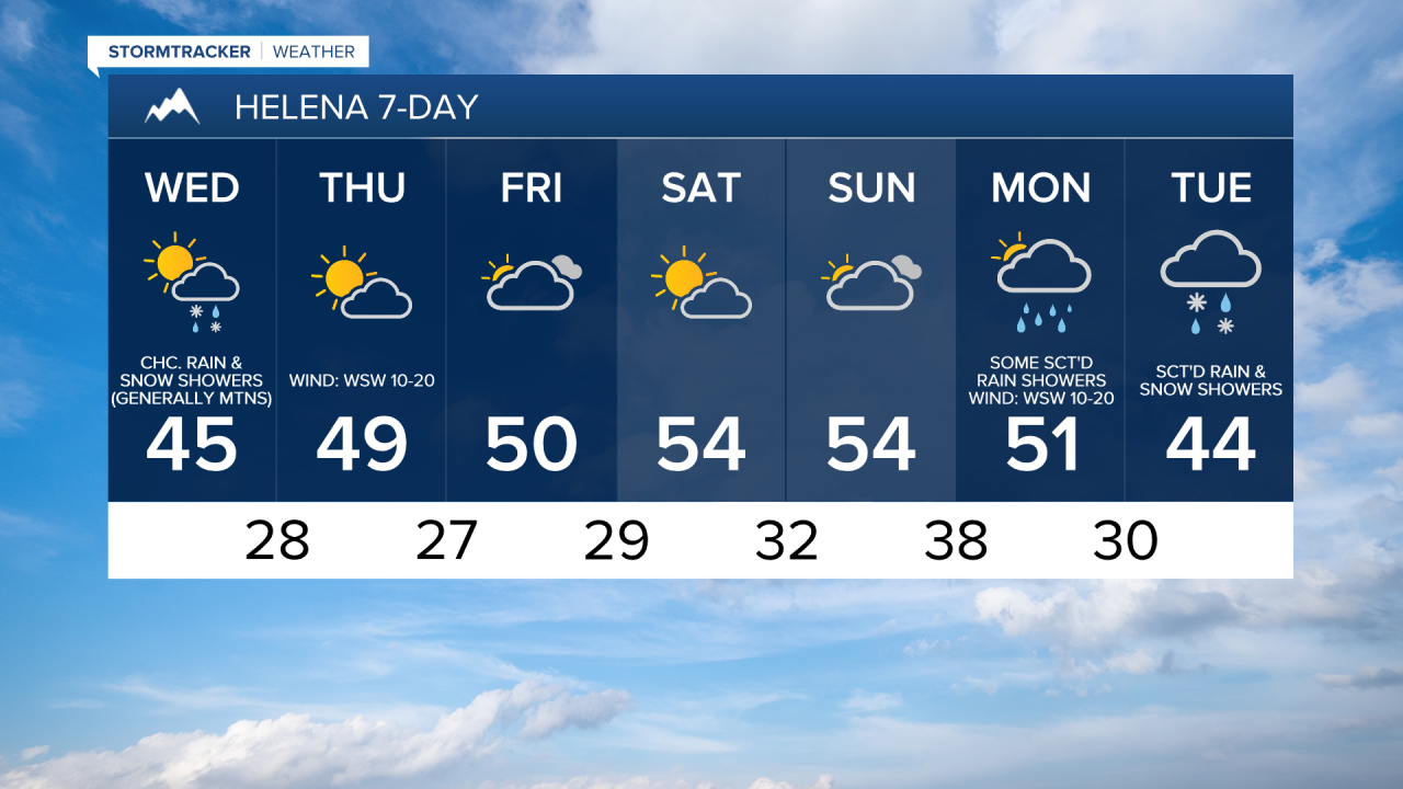
For tomorrow, we are going to have decreasing clouds with a slight chance of rain and snow showers in north-central Montana and a chance of rain and snow showers around the Helena area. Most of the precipitation that falls tomorrow is going to be in locations along and west of the Continental Divide though. Most of us are also going to get a break from the wind tomorrow as there is only going to be a little breeze around (sustained wind speeds between 5 and 15 mph). The one exception will be along the Rocky Mountain Front where we are going to have increasing wind tomorrow, with gusts over 40 mph possible during the afternoon and evening. It is also going to be cool again tomorrow as highs are going to be in the 40s and low 50s.
We are then going to have a strong southwesterly breeze around on Thursday as wind gusts over 75 mph are possible along the Rocky Mountain Front, and wind gusts over 50 mph are possible everywhere else. Also, sustained wind speeds on Thursday are going to be between 15 and 35 mph. This wind is going to create hazardous driving conditions, especially for high-profile vehicles, so please be careful when traveling. This wind is also going to blow around loose debris, so make sure you weigh/tie down anything that can easily blow away, including your Halloween decorations.
We are also going to have partly cloudy skies, mostly dry conditions, and seasonable temperatures on Thursday as highs are going to be in the mid to upper 40s and low to mid 50s.
Mild temperatures are then expected for Friday and this weekend as highs are going to be in the 50s, and a few spots may even top out in the lower 60s. We are also going to have a gusty southwesterly breeze around on these three days as sustained wind speeds are going to be between 10 and 25 mph, and wind gusts over 40 mph are going to be possible at times. Partly to mostly cloudy skies and mainly dry conditions are also expected over these three days.
On Monday, we are going to have a chance to see some rain and mountain rain/snow showers, especially around the Helena area, as another disturbance begins to approach our area. There are then going to be scattered rain and snow showers around on Tuesday as this disturbance passes through our area. We are also going to have partly to mostly cloudy skies on these two days. The temperatures are also going to cool down some over these two days as highs are going to be in the low to mid 50s on Monday and the 40s on Tuesday. A strong westerly/southwesterly breeze is also expected on Monday as sustained wind speeds are going to be between 15 and 30 mph, and wind gusts up to 50 mph are going to be possible at times.