


Good Morning and happy Wednesday! It is going to be windy today as sustained wind speeds are going to be between 15 and 30 mph, and wind gusts of 40-50+ mph are expected. A LAKE WIND ADVISORY is in effect for Fort Peck Lake until 9pm Thursday. The wind will diminish some tonight, but it will continue to be breezy as sustained wind speeds are going to be between 10 and 25 mph, and wind gusts up to 40 mph are possible.

In north-central Montana, there are going to be scattered showers and a few isolated thunderstorms around today, especially during the afternoon and evening. There will be a little sunshine initially, but most of today will be mostly cloudy to overcast. Around Helena, the cloud cover will increase as the day goes on and there will be scattered showers and isolated thunderstorms around, mainly during the evening.
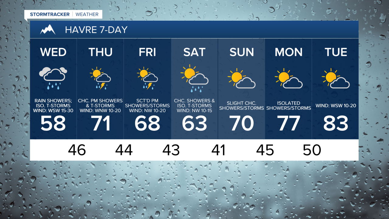
Here is today's forecast:
Scattered showers and isolated thunderstorms will continue tonight, mainly in locations east of I-15. It is also going to be cold enough that there will be some snow in the mountains today and tonight as snow levels will be as low as 5000-6000 feet, and light snow accumulations are possible.

Much cooler temperatures are also expected today as highs are only going to be in the 50s and low 60s. It will then be cool tonight as lows are going to be in the 40s and low 50s.
There will continue to be a good breeze around tomorrow as sustained wind speeds are going to be between 10 and 25 mph, and wind gusts up to 40 mph are possible. The temperatures will also warm back up tomorrow as highs are going to be in the mid to upper 60s and low to mid 70s. Around Helena, it will be mostly sunny and mostly dry tomorrow. In north-central Montana, it will be partly cloudy tomorrow and there will be a few showers and thunderstorms around east of I-15, generally during the afternoon and evening.
Another storm system will bring scattered showers and some thunderstorms to our area later Friday into Saturday. Friday will be partly to mostly sunny (via increasing clouds), while Saturday will be partly to mostly cloudy. The temperatures will also cool down some between these two days as highs are going to be in the mid to upper 60s and low to mid 70s on Friday and the mid to upper 50s and low to mid 60s on Saturday. There will also be a little breeze around on these two days as sustained wind speeds are going to be between 5 and 20 mph.
On Sunday, it is going to be partly cloudy and there will be a few showers and thunderstorms around, generally during the afternoon and evening. It is also going to be warmer on Sunday as highs are going to be in the 60s and low 70s.
There are going to be some more scattered showers and thunderstorms around on Monday as another disturbance impacts the state. Partly cloudy skies and mostly dry conditions are then expected on Tuesday. Much warmer temperatures are also expected early next week as highs are going to be in the 70s on Monday and the mid to upper 70s and low to mid 80s on Tuesday. There will also be a breeze around on Tuesday as sustained wind speeds are going to be between 10 and 25 mph.


Have a wonderful Wednesday!
Chief Meteorologist Ryan Dennis
