


There was some light snow around this morning as a cold front passed through our area. Most locations received little (a dusting) to no snow accumulation, but locations in between Great Falls and Helena and in between Great Falls and Lewistown received a coating to a couple inches of snow. The Little Belts and Snowies received a few inches of snow, with Neihart receiving 6” of snow as of lunchtime. The cold front also brought gusty to strong winds to our area this morning, with many locations recording wind gusts between 30 and 50 mph.
Here is the detailed forecast:
The cloud cover will increase tonight and there will be a few snow showers around later tonight and tomorrow morning, generally in the mountains and along the eastern half of the Hi-Line, as another front passes through our area. Minimal snow accumulation is expected with this front, with <2” in the mountains and <1” in the lower elevations. Tomorrow will be mostly to partly cloudy, with the skies clearing out some as the day goes on.

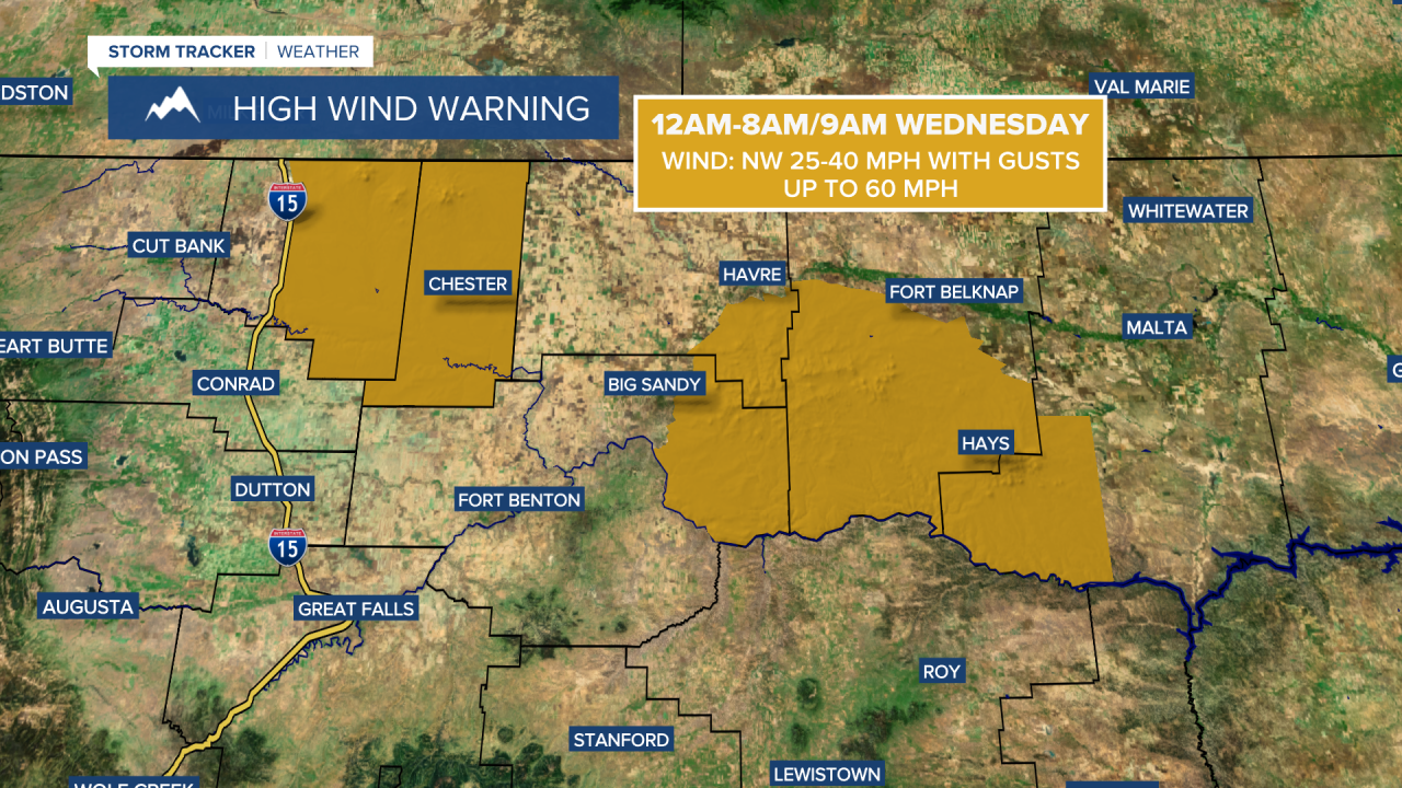
Around and west of I-15, there will be a bit of a breeze around tonight, generally before midnight, as sustained wind speeds are going to be between 10 and 20 mph. East of I-15, gusty winds are expected tonight as sustained wind speeds are going to be between 10 and 30 mph, and wind gusts up to 50 mph are possible. A HIGH WIND WARNING is in effect for the Bear Paw mountains, eastern Toole County, Liberty County, and southwestern Phillips County from 12am until 8am/9am Wednesday as gusts up to 60 mph are possible in these locations. The strongest wind tonight will occur with the passage of the front. It is also going to be cold tonight as lows are going to be in the teens and low 20s, with wind chills in the 0s and -0s.
Tomorrow will be a chilly day as highs are going to be in the 20s and low 30s in most locations. It is also going to be breezy tomorrow east of I-15 as sustained wind speeds are going to be between 10 and 25 mph, and wind gusts up to 40 mph are possible. Around and west of I-15, there will be little to no wind tomorrow.
The temperatures will continue to cool down as we head into the end of the week, with Thursday and Friday being the coldest days of the month so far. On Thursday, highs are going to be in the single digits, teens, and low 20s, and lows Thursday night are going to be in the -20s, -10s, and -0s. On Friday, highs are going to be in the -0s, 0s, and low to mid teens, and lows Friday night are going to be in the -10s, -0s, and 0s. Wind chills Thursday night and Friday night will be below zero and could get as low as -40° in northeastern Montana. Make sure you dress warmly and limit your time outdoors Thursday through Saturday morning as we are not acclimated to this cold with how mild it has been so far this winter.
Thursday will feature partly to mostly cloudy skies and there will be a few isolated snow showers around. Friday will be partly to mostly sunny and mainly dry. There is also just going to be a little breeze around on these two days as sustained wind speeds are going to be between 5 and 20 mph.
The temperatures will warm back up this weekend as a chinook wind develops with highs in the teens and 20s on Saturday and the 20s and 30s on Sunday. Along the Rocky Mountain Front, gusty winds are expected this weekend as gusts over 40 mph are possible. Out across the plains, it will be breezy in some areas this weekend as sustained wind speeds are going to be between 10 and 20 mph, and gusts over 30 mph are possible. On Saturday, it is going to be partly to mostly cloudy and there are going to be a few snow showers around as a disturbance passes through the state. Mostly sunny skies and dry conditions are then expected on Sunday.
The beginning of next week will be breezy as sustained wind speeds are going to be between 10 and 25 mph. Above average temperatures are also expected for the beginning of next week as highs are going to be in the 30s and low to mid 40s in most locations (teens and 20s in northeastern Montana). Monday will be partly to mostly cloudy and mostly dry, while Tuesday will be partly cloudy with some isolated snow showers around.


