A HEAT ADVISORY is in effect for portions of north-central Montana from 1pm Tuesday until 8pm Wednesday.

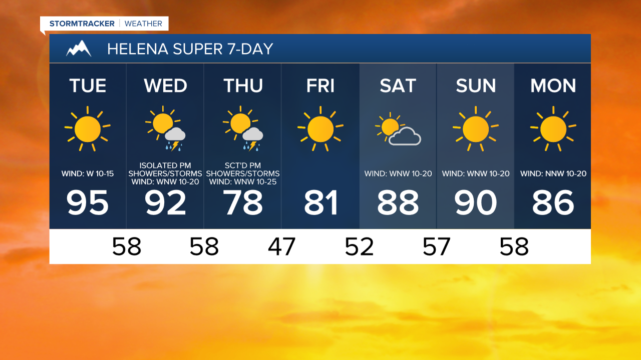
We are going to have clear skies, dry conditions, little to no wind, and pleasant temperatures tonight as lows are going to be in the 50s in most locations.
For tomorrow, it is going to be sunny, dry, and hot as highs are going to be in the 90s in most locations. There is also going to be a good breeze around tomorrow along the Rocky Mountain Front as sustained wind speeds are going to be between 10 and 25 mph, and it is going to be a bit breezy tomorrow in western portions of north-central Montana east of the Rocky Mountain Front as sustained wind speeds are going to be between 10 and 20 mph.
It is going to remain hot on Wednesday as highs are going to be in the upper 80s, 90s, and low 100s in most locations. We are also going to have partly to mostly sunny skies on Wednesday with a few scattered showers and thunderstorms around the Helena area during the afternoon/evening and some isolated showers and thunderstorms around east of I-15 in north-central Montana during the afternoon and evening.
Along the Rocky Mountain Front and in Glacier County, it is going to be gusty on Wednesday as sustained wind speeds are going to be between 15 and 30 mph. In western portions of north-central Montana east of the Rocky Mountain Front, it is going to be breezy on Wednesday as sustained wind speeds are going to be between 10 and 25 mph. Throughout the rest of north-central Montana, it is going to be a little breezy on Wednesday as sustained wind speeds are going to be between 5 and 20 mph. The combination of the wind and heat along with the potential for some dry thunderstorms will really increase the fire danger on Wednesday, so please do your part to not start any new fires.
Cooler temperatures are expected on Thursday as a cold front passes through our area as highs are going to be back in the 70s and low 80s in most locations. Widespread breezy conditions are also expected on Thursday as sustained wind speeds are going to be between 10 and 25 mph, and wind gusts up to 40 mph are possible. We are also going to have increasing clouds on Thursday with scattered showers and thunderstorms around, mainly during the afternoon and evening.
There are going to be some lingering showers and thunderstorms around on Friday in eastern portions of north-central Montana as this disturbance departs our area. We are also going to have mostly sunny skies and seasonable temperatures on Friday as highs are going to be in the mid to upper 70s and low 80s.
Beautiful summer weather is in the forecast for this weekend as we are going to have partly to mostly sunny skies and dry conditions on Saturday and lots of sunshine and dry conditions on Sunday. It is also going to be very warm/hot this weekend as highs are going to be in the mid to upper 80s and low to mid 90s. There is also going to be a bit of a breeze around this weekend as sustained wind speeds are going to be between 10 and 20 mph, and this wind will keep the fire danger elevated.