A HIGH WIND WATCH is in effect for Glacier County, western/central Pondera County, and western Toole County from 9am Sunday until 12am Monday.

We are going to have decreasing clouds tonight with just a few isolated snow showers around, generally during the evening. It is also going to be cold again tonight as lows are going to be in the teens and low 20s.
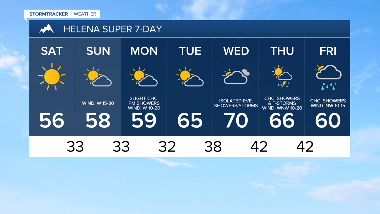
We are then going to have beautiful weather tomorrow as we are going to have lots of sunshine, dry conditions, little wind (sustained wind speeds between 5 and 20 mph), and much warmer temperatures as highs are going to be in the mid to upper 40s and low to mid 50s in most locations.
On Sunday, we are going to have partly cloudy skies with a few isolated rain and snow showers around, generally in the mountains, as a disturbance passes through our area. We are also going to have widespread gusty to strong winds around on Sunday, especially during the afternoon and evening, as sustained wind speeds in a lot of locations are going to be between 15 and 35 mph, and wind gusts up to 50 mph are possible. Per usual, even stronger wind is expected along the Rocky Mountain Front and in the Glacier County area where wind gusts up to 65 mph are possible. It is also going to be warmer on Sunday than it is going to be tomorrow as highs are going to be in the 50s and 60s, with the warmest temperatures in eastern portions of north-central Montana.
There are then going to be a few scattered rain and mountain snow/rain showers around on Monday, generally during the afternoon/evening and generally in locations east of I-15, as another disturbance passes through our area. We are also going to have widespread gusty to strong winds around again on Monday as sustained wind speeds in a lot of locations are going to be between 15 and 35 mph, and wind gusts over 40 mph are possible in western portions of north-central Montana, while wind gusts over 50 mph are possible in eastern portions of north-central Montana. It is also going to be cool on Monday as highs are going to be in the mid to upper 50s and low 60s in most locations. We are also going to have partly cloudy skies on Monday.
On Tuesday, we are going to have partly to mostly sunny skies, dry conditions, and warmer temperatures as highs are going to be in the upper 50s and low to mid 60s. We are then going to have partly to mostly cloudy skies on Wednesday with a few isolated showers and thunderstorms around during the afternoon/evening as another disturbance begins to impact our area. It is also going to be warm on Wednesday as highs are going to be in the mid to upper 60s and low to mid 70s. There is also going to be a little breeze around on Wednesday as sustained wind speeds are going to be between 5 and 20 mph.
There are then going to be a few scattered rain showers and thunderstorms around on Thursday and Friday as a couple disturbances pass through our area. We are also going to have partly cloudy skies on Thursday and mostly cloudy skies on Friday. The temperatures are also going to cool down some over these two days as highs are going to be in the 60s and upper 50s on Thursday and the mid to upper 50s and low to mid 60s on Friday. It is also going to be a bit breezy on these two days as sustained wind speeds are going to be between 10 and 20 mph.