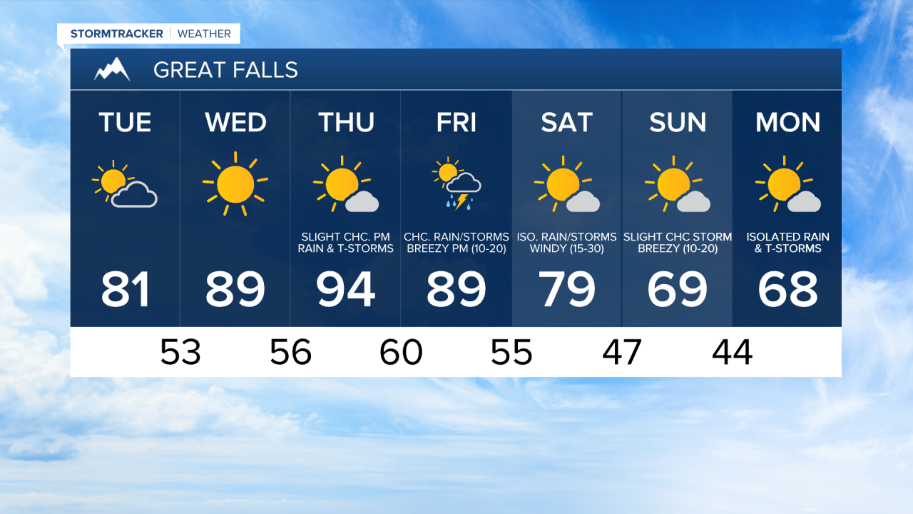
We are going to have filtered sunshine (partly cloudy skies) today as a weak disturbance passes by our area to the north. We are then going to have decreasing clouds tonight as this disturbance moves away from our area. It is also going to be warm today as highs are going to be in the upper 70s and low to mid 80s, and it is going to be mild tonight as lows are going to be in the low to mid 50s.
Lots of sunshine is then expected tomorrow as high pressure is going to be in control of our weather. It is also going to be warmer tomorrow than it is going to be today as highs are going to be in the mid to upper 80s and low 90s, and some locations may set a new record high temperature tomorrow.
Thursday is then going to be the hottest day this week as highs are going to be in the mid 90s, and many locations are likely going to set a new record high temperature on Thursday as these forecasted high temperatures are about 20 to 25° above average for this time of year. We are also going to have mostly sunny skies on Thursday with a slight chance of rain showers and thunderstorms during the afternoon and evening.
There are then going to be some scattered rain showers and thunderstorms around on Friday, mainly during the afternoon and evening, as a disturbance along the West Coast sends some moisture into our area. Some of the thunderstorms on Friday may also be severe with large hail and damaging winds possible. It is also going to be hot again on Friday, although it is not going to be quite as hot as Thursday is going to be, as highs are going to be in the upper 80s and low 90s. Breezy conditions are also expected Friday afternoon and evening as sustained wind speeds are going to be between 10 and 20 mph.
Our temperatures are then going to cool down a lot this weekend as highs on Saturday are going to be in the upper 70s and low 80s, and highs on Sunday are going to be in the upper 60s and low 70s. It is also going to be windy on Saturday as sustained wind speeds are going to be between 15 and 30 mph, and it is going to be breezy on Sunday as sustained wind speeds are going to be between 10 and 20 mph. We are also going to have mostly sunny skies with a few isolated rain showers and thunderstorms around on both Saturday and Sunday.
There are then going to be some more isolated rain showers and thunderstorms around on Monday as we continue to remain in a somewhat unsettled weather pattern. We are also going to have near to slightly below average temperatures on Monday as highs are going to be in the upper 60s and low 70s.