


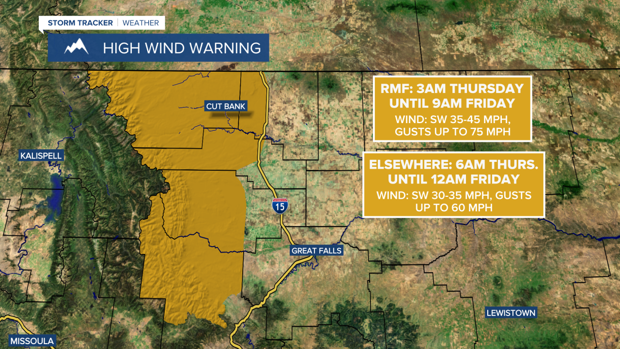
A HIGH WIND WARNING is in effect for the Rocky Mountain Front from 3am Thursday until 9am Friday. Sustained wind speeds are going to be between 35 and 45 mph, and wind gusts up to 75 mph are going to be possible at times. This wind is going to be coming out of the SW.
A HIGH WIND WARNING is in effect for eastern Glacier County, central Pondera County, and western Toole County from 6am Thursday until 12am Friday. Sustained wind speeds are going to be between 30 and 35 mph, and wind gusts up to 60 mph are going to be possible at times. This wind is going to be coming out of the SW.
The wind is going to increase tonight, and it is going to become windy along the Rocky Mountain Front and breezy in locations east of the Rocky Mountain Front. By sunrise tomorrow morning, gusts over 60 mph are possible along the Rocky Mountain Front, and gusts over 40 mph are possible in locations east of the Rocky Mountain Front. We are then going to have strong winds around throughout the day tomorrow as sustained wind speeds are going to be between 15 and 35 mph in many locations, and gusts up to 75 mph are possible along the Rocky Mountain Front, while gusts over 50 mph are possible in locations east of the Rocky Mountain Front. Valley locations, including Helena, will avoid the brunt of this wind though, as there is only going to be a bit of a breeze around tomorrow (sustained wind speeds between 10 and 20 mph).
This wind is going to create hazardous driving conditions, especially for high-profile vehicles, so please be careful when traveling. This wind is also going to blow around loose objects, so make sure you weigh/tie down anything that can easily blow away, including your Halloween decorations. Also, the wind tomorrow is going to be coming out of the WSW or SW in most locations.
We are also going to have partly cloudy to mostly clear skies tonight with a few isolated mountain snow showers around. We are then going to have decreasing clouds tomorrow with a few snow showers around in Glacier National Park. It is also going to be cold tonight as lows are going to be in the mid to upper 20s and low to mid 30s, and it is going to be cool tomorrow as highs are going to be in the mid to upper 40s and low to mid 50s. When you factor in the wind, it will feel about 5 to 15 degrees colder in most locations tonight and tomorrow.
Mild temperatures are then expected for Friday and this weekend as highs are going to be in the 50s, and a few spots may even top out in the lower 60s. We are also going to have a gusty to strong southwesterly breeze around on these three days as sustained wind speeds are going to be between 10 and 30 mph, and wind gusts over 40 mph are possible east of the Rocky Mountain Front, while wind gusts over 50 mph are possible along the Rocky Mountain Front. Partly to mostly cloudy skies and mainly dry conditions are also expected over these three days.
On Monday, we are going to have a chance to see some rain and mountain rain/snow showers, especially in the mountains and around the Helena area, as a storm system begins to approach our area. There is also going to be a strong westerly-southwesterly breeze around on Monday as sustained wind speeds are going to be between 15 and 35 mph, and wind gusts over 50 mph are going to be possible at times. It is also going to be mild again on Monday as highs are going to be in the 50s.
Colder and wetter weather is then expected for the first few days of November. On Tuesday, there are going to be scattered rain and snow showers around, and the snow levels are going to be getting lower as the day goes on. There are then going to be scattered snow showers around on Wednesday. The temperatures are also going to cool down some over these two days as highs are going to be in the 40s on Tuesday and the 30s on Wednesday. There is also going to be a little breeze around on these two days as sustained wind speeds are going to be between 5 and 20 mph, and this wind is going to be coming out of the WNW.


