


It has been breezy and chilly today and there have been scattered snow/graupel showers around throughout the afternoon and evening. The scattered snow showers will continue through sunset. There will then just be some isolated snow showers around overnight. It is going to be partly cloudy to mostly clear and cold tonight as lows are going to be in the teens and low to mid 20s. Breezy conditions are also expected tonight along the Rocky Mountain Front and the western half of the Hi-Line as sustained wind speeds are going to be between 10 and 25 mph. Elsewhere, it will be a little breezy tonight as sustained wind speeds are going to be between 5 and 20 mph.
Here is the detailed forecast:
Tomorrow will be a partly cloudy day, with the cloud cover increasing some during the afternoon and evening. Along the Divide, snow is likely throughout the day. East of the Divide, isolated snow and rain showers are possible, but most locations will remain dry. Windy conditions are also expected tomorrow as sustained wind speeds are going to be between 15 and 30 mph in a lot of locations, and wind gusts up to 50 mph are possible. It will also be a little warmer tomorrow as highs are going to be in the 40s in most locations.
A WINTER WEATHER ADVISORY is in effect for the Glacier area and the Rocky Mountain Front through 6pm Wednesday as 1-8” of new snow is possible.

Another strong wind event is expected tomorrow night through Thursday. Along the Rocky Mountain Front and in the Cut Bank area, sustained wind speeds are going to be between 35 and 55 mph, and gusts up to 85 mph are possible (gusts of 95+ mph are possible along the immediate eastern slopes of the Rocky Mountain Front). A HIGH WIND WARNING is in effect for this area from 6pm Wednesday until 3pm Thursday.

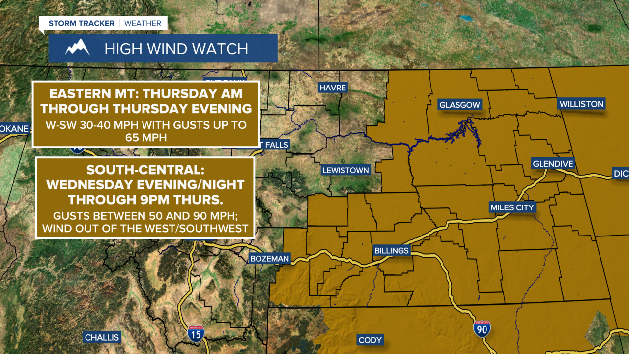
East of the Rocky Mountain Front in north-central Montana and around the Helena area, sustained wind speeds are going to be between 25 and 45 mph, and gusts between 65 and 85 mph are expected. A HIGH WIND WARNING is in effect for this area from 12am/3am until 6pm Thursday. There is also a HIGH WIND WATCH in effect for northeastern Montana from Thursday morning through Thursday evening as gusts up to 65 mph are possible.
Due to the recent strain on infrastructure and vegetation, there will be an increased risk for wind damage, including downed trees and power lines as well as damage to infrastructure. Travel will also be difficult for high-profile vehicles and vehicles pulling trailers. Power outages are possible. Prepare now for this upcoming strong wind event.
The wind dies down as we head into Friday, but it will still be gusty as sustained wind speeds are going to be between 10 and 30 mph, and wind gusts over 40 mph are possible. Saturday will be another gusty day for the Helena area as sustained wind speeds are going to be between 10 and 30 mph, while in north-central Montana, it will just be breezy as sustained wind speeds are going to be between 10 and 20 mph.
A significant storm with lots of Pacific moisture will also impact Montana Thursday through Saturday. On Thursday, snow is likely in the mountains; rain/snow is likely around Helena; and there are going to be some scattered rain and snow showers around in north-central Montana. On Friday, snow is likely in north-central Montana and in the mountains. Around Helena, a mixture of rain and snow is likely as a cold front stalls out in the middle of the state. Where exactly the cold front stalls out on Friday will determine where the rain/snow line ends up being. Widespread snow is then likely in north-central Montana on Saturday, while a rain/snow mix will continue around Helena.
There is still a lot of uncertainty as to how much snow falls in the lower elevations, but significant accumulations are possible in some areas. A WINTER STORM WATCH is in effect for a lot of north-central Montana from Thursday evening/night through 6pm Saturday. 9-18” of snow is possible for the foothills and plains near the Rocky Mountain Front; 10-20” of snow is possible in southern Blaine County, Fergus County, Judith Basin County, and the mountains; and 6-12” of snow is possible elsewhere. Along the Rocky Mountain Front and in Glacier National Park, 1-4 FEET of snow is expected, and a WINTER STORM WARNING is in effect for this area from 6pm Wednesday until 12pm/6pm Saturday.


Travel will be difficult to impossible in the higher terrain in western Montana tomorrow through Saturday due to heavy snow and whiteout conditions. Many mountain passes will be impacted. Travel will also be difficult in some of the lower elevations Thursday night through Saturday. Use extreme caution when traveling later this week.
Highs on Thursday will be in the 40s and upper 30s in most spots. The temperatures will then cool-down into the 20s and 30s in north-central Montana for Friday and Saturday. Around Helena, highs will remain in the 40s on Friday, but will cool down into the 30s and low 40s on Saturday.
A few more snow showers are then possible on Sunday as another disturbance impacts the state. It is also going to be mostly cloudy and chilly as highs are going to be in the mid to upper 20s and low to mid 30s in most locations. Warmer and well above-average temperatures will then return next week as highs will be back in the 60s as early as Tuesday.


