


It has been an active afternoon/evening of weather as a cold front has been passing through our area. There have been scattered showers and thunderstorms around, and several of the thunderstorms were severe with damaging winds. Many locations recorded wind gusts of 60+ mph, with a location northwest of Big Sandy recording a wind gust of 85 mph!
This wind caused some damage, including a couple carports in Havre being destroyed, trees in Havre and Great Falls being knocked down, a roof being partially blown off in Box Elder, as well as multiple power outages. The strong winds also picked up a ton of dust and caused a massive dust storm, also known as a haboob, that impacted portions of the Hi-Line, specifically in and around Hill County, earlier this evening. For photos/videos of the damage, head here: https://www.krtv.com/weather/storm-recap-may-13-2026
Detailed forecast:
A SEVERE THUNDERSTORM WATCH remains in effect for a lot of the state through 9pm/11pm Wednesday. There will continue to be scattered showers and thunderstorms around this evening and early tonight. All thunderstorms will be capable of producing strong winds, frequent lightning, heavy rainfall, and small to medium-sized hail. A few of these thunderstorms may turn severe with damaging winds (60+ mph), but the main severe threat is now over with. During the second half of the night, there will just be a few areas of rain around, generally along the Hi-Line.

There is also going to be snow around tonight and tomorrow morning in the Rockies and in Glacier National Park. Some of the highest peaks may receive over a half foot of snow. A WINTER WEATHER ADVISORY is in effect for the Glacier area from 12am-12pm/3pm tomorrow as 2-6+” of snow is possible above 5000 feet.

Tomorrow, we are going to have partly to mostly sunny skies via decreasing clouds. There will be some showers along the Hi-Line east of I-15 during the morning, but this rain will taper off as we go through the morning, with mostly dry conditions expected during the afternoon and evening. It is also going to be a lot cooler tomorrow as highs are going to be back in the 60s and upper 50s.
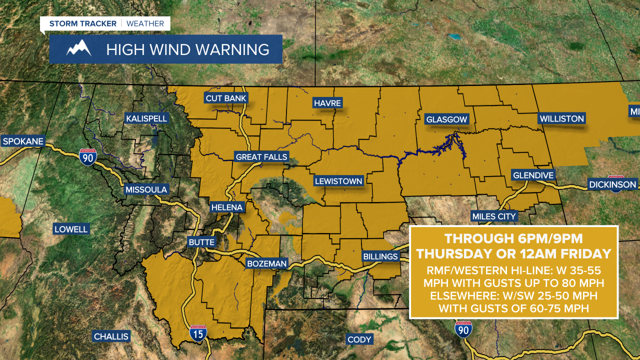
It is going to be very windy tonight and tomorrow. Sustained wind speeds are going to be between 20 and 45 mph, and wind gusts are going to be between 50 and 75 mph. This wind will be coming out of the west/southwest and will make travel difficult for high-profile vehicles. This wind may also cause some wind damage. A HIGH WIND WARNING is in effect for a lot of central and northeastern Montana through Thursday evening/night.
The gusty to strong winds will continue on Friday, although the wind won’t be quite as strong as it will be tomorrow, as sustained wind speeds are going to be between 15 and 30 mph, and wind gusts over 50 mph are possible. Outside of the wind, the weather will be pretty nice on Friday as it is going to be partly to mostly sunny and there are just going to be some isolated rain and mountain snow showers around. We are also going to have seasonable temperatures on Friday as highs are going to be in the 60s.
On Saturday, there are going to be some scattered rain and mountain snow showers around, generally in the higher terrain and in central Montana. There are then going to be scattered rain and mountain snow showers around on Sunday as a stronger disturbance impacts the state. Some lower elevation locations may also see some snow on Sunday, although little to no accumulation is expected. It is also going to be partly to mostly cloudy this weekend.
The temperatures will cool down this weekend as highs are going to be in the mid to upper 50s and low to mid 60s on Saturday and the mid to upper 40s and low 50s on Sunday. Gusty winds are also expected this weekend as sustained wind speeds are going to be between 10 and 30 mph, and wind gusts over 40 mph are possible.


