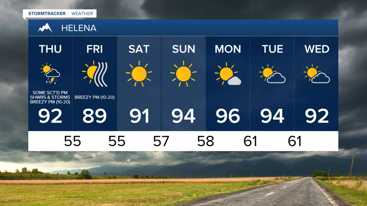
There are going to be some scattered rain showers and thunderstorms around this evening and early tonight as some monsoonal moisture works its way into our area. We are then going to have decreasing clouds with a few isolated rain showers and thunderstorms around after midnight. For tomorrow, we are going to have increasing clouds with some scattered rain showers and thunderstorms around, generally during the afternoon and evening and mainly in locations east of I-15. Some of the thunderstorms this evening, tonight, and tomorrow may also be severe with damaging wind gusts, large hail, frequent lightning, and brief heavy rainfall, so definitely keep an eye to the sky if you are going to be outdoors at all.


Mild temperatures are expected tonight as lows are going to range from the upper 50s to the upper 60s. It is then going to be hot again tomorrow as highs are going to be in the low to mid 90s in central Montana and the low 100s in eastern Montana. There is also an Excessive Heat Warning in effect until 9pm tomorrow for eastern Montana. Breezy conditions are also expected tomorrow afternoon/evening, especially in central and western Montana, as sustained wind speeds are going to be between 10 and 25 mph.

On Friday, we are going to have mostly to mainly sunny skies and dry conditions. It is also going to be a touch cooler on Friday than it is going to be tomorrow as highs are going to be in the mid to upper 80s in central Montana and the low to mid 90s in eastern Montana. Breezy conditions are also expected for most of Montana on Friday, especially during the afternoon and evening, as sustained wind speeds are going to be between 10 and 25 mph.
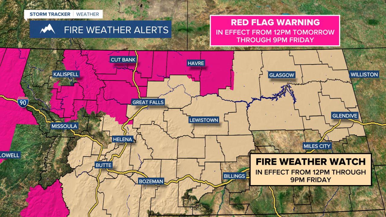
Since it is going to be breezy tomorrow and Friday, and since we are going to have low relative humidity, especially during the day on Friday, there is a Red Flag Warning in effect for parts of the Hi-Line and parts of the Rocky Mountain Front from 12pm tomorrow until 9pm on Friday. There is also a Fire Weather Watch in effect for northeastern Montana, southwestern Montana, and parts of central Montana from 12pm until 9pm on Friday. Any fires that start over the next two days are going to be able to rapidly spread due to breezy and dry conditions, and that is why we have these fire weather alerts in effect.
Lots of sunshine and dry conditions are then expected this weekend and on Monday. We are then going to have partly cloudy skies and mostly dry conditions next Tuesday and Wednesday. It is also going to continue to be very warm/hot this weekend and next week as highs are generally going to be in the upper 80s and low to mid 90s. It is also going to be a little breezy in eastern Montana this weekend and on Monday as sustained wind speeds are going to be between 10 and 15 mph. There is also going to be a bit of a breeze around along the Hi-Line this weekend and early next week as sustained wind speeds are going to be between 10 and 20 mph.
Smoky/hazy skies are also expected for the foreseeable future in all of Montana due to wildfires burning locally and regionally. With this smoke/haze in the air, it is possible that the air quality may become unhealthy for sensitive groups at times, so if you are sensitive to increased particulates in the atmosphere, then you may want to try and limit your time outdoors.