


A WINTER STORM WARNING is in effect for portions of western Montana until 8pm Thursday and for portions of southern and central Montana until 5am/11am Friday. Up to 5 inches of new snow accumulation is possible in the lower elevations, and up to 8 inches of new snow accumulation is possible in the mountains.

A WINTER WEATHER ADVISORY is in effect for portions of western, central, and southern Montana until 11pm Thursday or 5am/8am/11am Friday. Up to 3 inches of new snow accumulation is possible in the lower elevations and up to 6 inches of new snow accumulation is possible in the mountains.

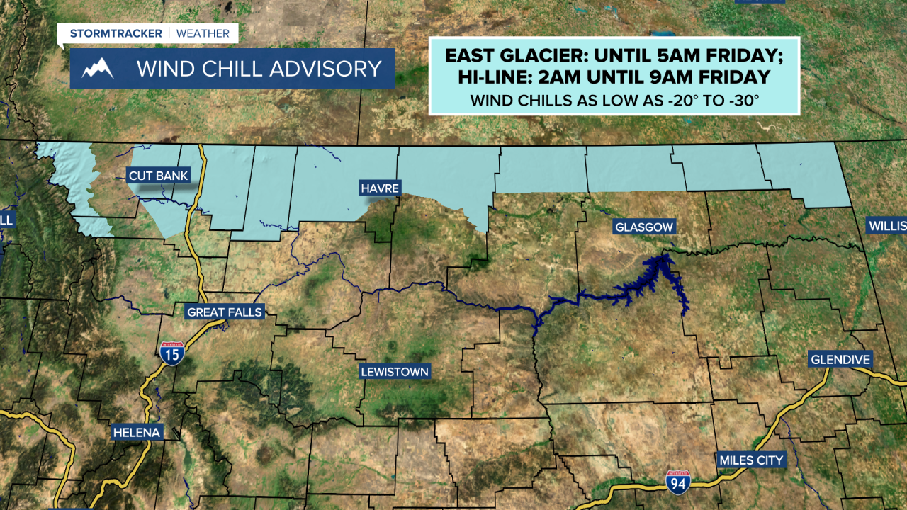
A WIND CHILL ADVISORY is in effect for the East Glacier area until 5am Friday and for most of the Hi-Line east of the Divide from 2am until 9am Friday. Wind chills as low as -20° to -30° are possible.
Widespread light to moderate snow will continue to impact central and southern Montana as well as western and southern portions of north-central Montana this evening and tonight. However, as we go through tonight, this snow is going to gradually taper off, and by sunrise tomorrow, most locations will be dry (just some lingering light snow in southern Montana around and south of I-90).
For most of central and north-central Montana, less than 3 inches of new snow accumulation is expected by tomorrow morning. Roads are also going to be slick/snow-covered in a lot of areas this evening, tonight, and tomorrow morning, so please use extreme caution when driving and give yourself some extra time to get to where you need to go.
The skies will also begin to clear out later tonight in northern Montana. Decreasing clouds are then expected tomorrow, with a lot of the state seeing lots of sunshine tomorrow afternoon and evening. There are also going to be patchy areas of fog around tonight and tomorrow morning.
It is also going to be very cold tonight as lows are going to be in the 0s and -0s in a lot of locations (some -10s along the Hi-Line), and wind chills as low as 20 to 30 below zero are possible, especially along the Hi-Line. It is then going to be cold tomorrow as highs are going to be in the mid to upper teens and low 20s in most locations. There is also going to be a bit of a breeze around tomorrow in northeastern Montana and eastern portions of north-central Montana as sustained wind speeds are going to be between 10 and 20 mph.
Lots of sunshine and dry conditions are then expected on Saturday as high pressure is going to be in control of our weather. There may also be some fog around in the valleys Saturday morning. It is also going to be warmer on Saturday than it is going to be tomorrow as highs are going to be in the mid to upper 20s and low to mid 30s in most locations. There is also going to be a breeze around in some areas on Saturday as sustained wind speeds are going to be between 10 and 20 mph.
We are then going to have partly to mostly cloudy skies on Sunday with PM snow showers around the Helena area and a couple isolated PM snow and rain showers around in north-central Montana (generally in the mountains) as a disturbance passes through our area. It is also going to feel nice outside on Sunday as highs are going to be in the 30s and low 40s in most locations. There is also going to be a breeze around in some areas on Sunday as sustained wind speeds are going to be between 10 and 20 mph.
Partly cloudy to mostly sunny skies and mostly dry conditions (just a few isolated snow/rain showers around) are then expected for most of next week as an upper-level ridge is going to be in control of our weather. It is also going to feel nice outside next week as highs are going to be in the 30s and low to mid 40s in most locations. There is also going to be a bit of a breeze around in some areas each day next week as sustained wind speeds are going to be between 10 and 20 mph.


