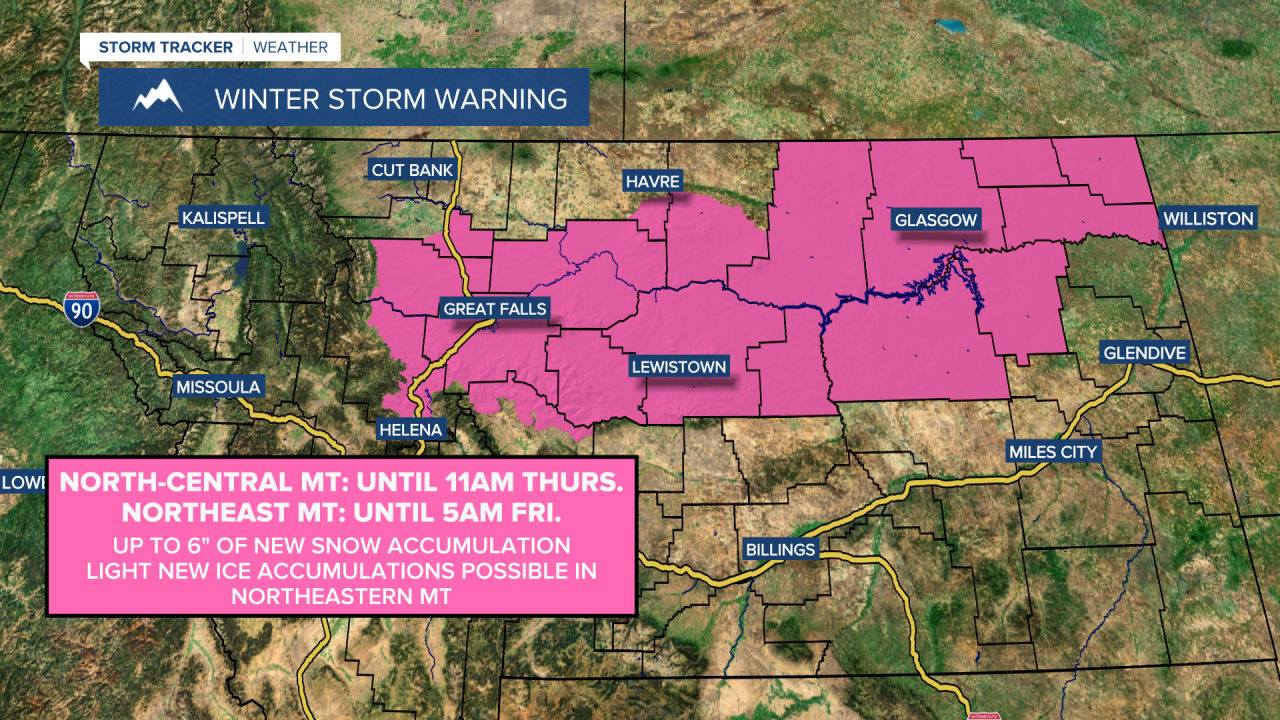
A WINTER STORM WARNING is in effect for portions of north-central Montana until 11am Thursday and for most of northeastern Montana until 5am Friday. Up to 6 inches of new snow accumulation is possible. Light new ice accumulations are also possible in northeastern Montana.
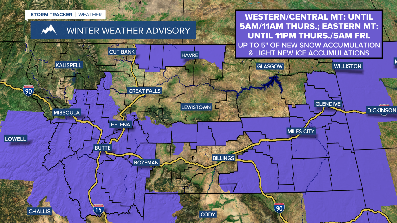
A WINTER WEATHER ADVISORY is in effect for portions of western and central Montana until 5am/11am Thursday and for portions of eastern Montana until 11pm Thursday/5am Friday. Up to 5 inches of new snow accumulation and light new ice accumulations are possible.
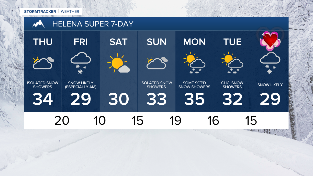
There are going to continue to be areas of light to moderate snow around this evening and tonight, but this snow will begin to gradually taper off from west to east as we go through tonight, especially once we get past midnight. There is then going to be some snow around tomorrow in eastern Montana and eastern portions of north-central Montana, but this snow will gradually taper off as the day goes on. In the rest of north-central Montana as well as around the Helena area, we are going to have mostly cloudy skies tomorrow with isolated snow showers around, generally in the mountains.
In north-central and central Montana, up to 3 or 4 inches of new snow accumulation is possible through tomorrow evening. In eastern Montana, up to 5 or 6 inches of new snow accumulation is possible through tomorrow evening. Roads are also going to be slippery in a lot of areas tonight and tomorrow, so please use extreme caution when driving and give yourself some extra time to get to where you need to go.

It is also going to be breezy in some areas east of I-15 tonight and tomorrow as sustained wind speeds are going to be between 10 and 25 mph. This wind is also going to cause there to be areas of blowing snow around, which will be another hazard to contend with if you are going to be traveling anywhere. Also, lows tonight are going to be in the teens and 20s, and highs tomorrow are going to be in the upper 20s and low to mid 30s in most locations.
Another round of primarily light snow is then expected tomorrow night and Friday (especially between midnight and noon on Friday) as another disturbance passes through our area. With this disturbance, a coating to 3 inches of new snow accumulation is possible. We are also going to have overcast skies on Friday, and it will be a little breezy on Friday as sustained wind speeds are going to be between 5 and 20 mph. Also, highs on Friday are going to be in the mid to upper 20s and low 30s.
Mostly sunny skies and mainly dry conditions are then expected on Saturday as high pressure is briefly going to be in control of our weather. We are then going to have a chance to see a little more snow (and possibly a little rain) on Sunday as another disturbance passes through our area. We are also going to have mostly cloudy skies on Sunday.
The temperatures are also going to warm up some this weekend as highs are going to be in the 20s and low to mid 30s on Saturday, and the 30s and upper 20s on Sunday. It is also going to be gusty this weekend along the Rocky Mountain Front as sustained wind speeds are going to be between 15 and 30 mph, and it is going to be a bit breezy this weekend in some areas east of the Rocky Mountain Front as sustained wind speeds are going to be between 10 and 20 mph.
On Monday, there are going to be some scattered snow showers around the Helena area and we are going to have a chance to see some snow and rain showers in north-central Montana, generally in the mountains and along the Hi-Line, as another disturbance passes through our area. A few more scattered snow showers are then possible on Tuesday. We are also going to have partly cloudy skies on these two days. There is also going to be a bit of a breeze around in some areas on these two days as sustained wind speeds are going to be between 10 and 20 mph. Highs on these two days are also going to be in the 30s and upper 20s in most locations.
There are then going to be scattered areas of snow around on Valentine’s Day (Wednesday) as a stronger storm system begins to impact our area. It is also going to be a little cooler on Valentine’s Day as highs are going to be in the mid to upper 20s and low 30s in most locations.