A HIGH WIND WARNING is in effect for all of Glacier County, western and central Pondera County, and western Toole County until 5am Wednesday. Sustained wind speeds are going to be between 25 and 40 mph, and wind gusts between 60 and 70 mph are possible.

A WINTER WEATHER ADVISORY is in effect for portions of southwestern, central, and north-central Montana from 6pm Wednesday/12am Thursday until 6am/9am Friday. In the lower elevations, a coating to 4 inches of snow accumulation is expected. In the mountains and along the Rocky Mountain Front, 2 to 8 inches of snow accumulation is expected. Winds are also going to be gusting as high as 40 mph at times.

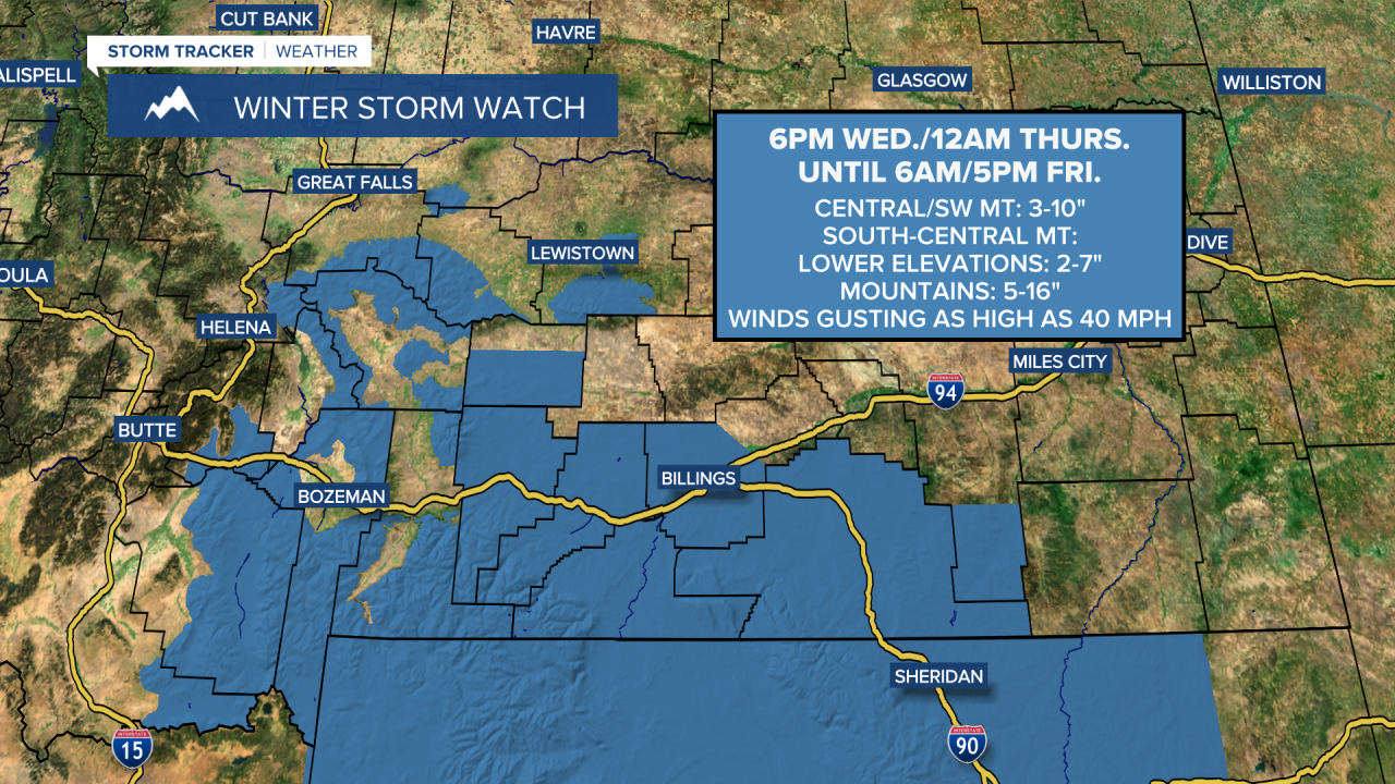
A WINTER STORM WATCH is in effect for portions of central and southwestern Montana from 6pm Wednesday until 6am Friday and for portions of south-central Montana from 6pm Wednesday/12am Thursday until 5pm Friday. In central and southwestern Montana, 3 to 10 inches of snow accumulation is expected. In south-central Montana, 2 to 7 inches of snow accumulation is expected in the lower elevations and 5 to 16 inches of snow accumulation is expected in the mountains. Winds are also going to be gusting as high as 40 mph at times.
We are going to have mostly cloudy skies tonight with a few isolated rain and mountain snow showers around after midnight in north-central Montana. It is also going to be windy tonight along the Rocky Mountain Front as sustained wind speeds are going to be between 20 and 40 mph, and wind gusts over 60 mph are possible. East of the Rocky Mountain Front, we are going to have gusty winds around tonight as sustained wind speeds are going to be between 10 and 30 mph, and wind gusts over 40 mph are possible. We are also going to have above average temperatures tonight as lows are going to be in the 30s and low to mid 40s.
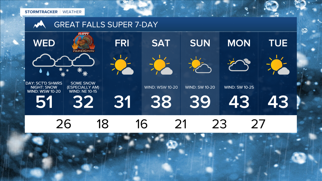
For tomorrow, we are going to have mostly cloudy to overcast skies with scattered showers around throughout the day. In the lower elevations, the showers tomorrow will initially be in the form of rain, but this rain will start to mix in with and transition over to snow during the afternoon and evening from north to south. We are also going to have decreasing wind tomorrow, so gusty winds (gusts over 40 mph) during the morning will gradually weaken as the day goes on. It is also going to be cool tomorrow as highs are going to be in the 40s and low 50s in most locations.
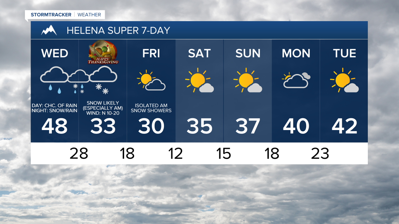
There are then going to be scattered areas of precipitation around tomorrow night. In the lower elevations, this precipitation may start out as rain, but will quickly transition over to snow. There is then going to be some snow around on Thanksgiving in north-central Montana in locations that are around and south/west of a line from Cut Bank to Great Falls to Lewistown. North and east of this line, a few snow showers are possible on Thanksgiving. Snow is also likely on Thanksgiving around the Helena area and in southern Montana. For central and north-central Montana, a lot of the snow will fall during the morning, with the snow tapering off and the skies even clearing in some locations during the second half of the day.
In the mountains in north-central, central, and southwestern Montana, 2 to 10 inches of snow accumulation is expected by Friday morning. In the mountains in south-central Montana, 5 to 16 inches of snow accumulation is expected by Friday evening. In the lower elevations in north-central, central, and southwestern Montana, a coating to 4 inches of snow accumulation is expected by Friday morning. In the lower elevations in south-central Montana, 2 to 7 inches of snow accumulation is expected by Friday evening. For all other locations, up to 2 inches of snow accumulation is possible, with most spots receiving little to no snow accumulation over the next couple of days.
It is also going to be a lot colder on Thanksgiving as highs are only going to be in the upper 20s and low to mid 30s in most locations. There is also going to be a breeze around on Thanksgiving around the Helena and Great Falls areas as sustained wind speeds are going to be between 10 and 20 mph.
On Black Friday, we are going to have decreasing clouds with a few snow showers around the Helena area, generally during the morning and generally in the mountains. It is also going to be cold again on Friday as highs are going to be in the upper 20s and low to mid 30s in most locations.
We are then going to have partly cloudy to mostly sunny skies this weekend with a few isolated snow showers around, generally in locations east of I-15, as a couple weak disturbances pass through our area. It is also going to be chilly this weekend as highs are going to be in the mid to upper 30s and low to mid 40s in most locations. There is also going to be a breeze around in some areas this weekend as sustained wind speeds are going to be between 10 and 20 mph.
We are then going to have mostly cloudy skies and mostly dry conditions on Monday and partly cloudy to mostly sunny skies and mainly dry conditions on Tuesday as high pressure is going to be in control of our weather. It is also going to be a little bit warmer on these two days than it is going to be this weekend as highs are going to be in the upper 30s and low to mid 40s in most locations. Breezy conditions are also expected on Monday as sustained wind speeds are going to be between 10 and 25 mph.