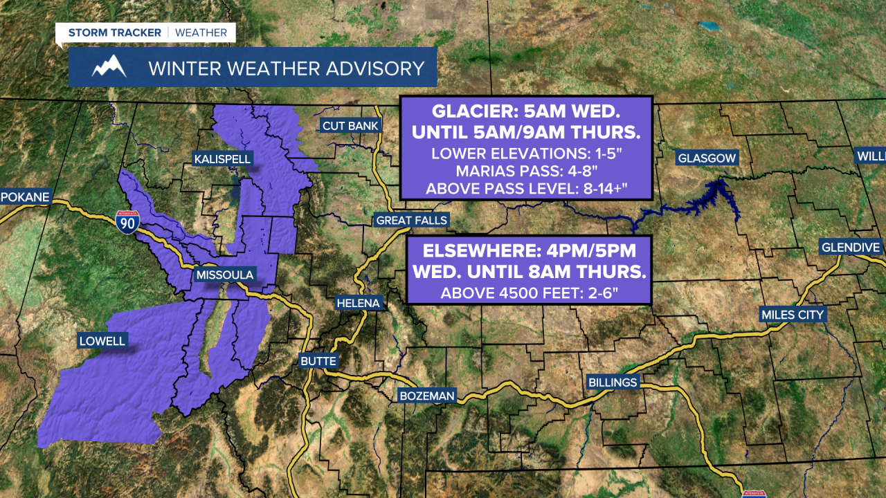
A WINTER WEATHER ADVISORY is in effect for the Glacier National Park area from 5am Wednesday until 5am/9am Thursday. 1 to 5 inches of snow accumulation is expected in the lower elevations; 4 to 8 inches of snow accumulation is expected at Marias Pass; and 8 to 14+ inches of snow accumulation is expected above pass level.
A WINTER WEATHER ADVISORY is in effect for the Lower Clark Fork region, the Potomac/Seeley Lake area, and the Bitterroot/Sapphire Mountains in western Montana from 4pm/5pm Wednesday until 8am Thursday. 2 to 6 inches of snow accumulation is expected above 4500 feet.
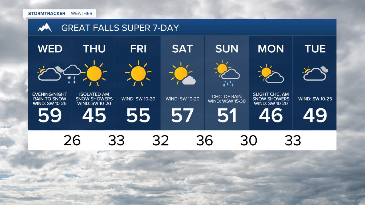
We are going to have increasing clouds and mainly dry conditions tonight. It is also going to be cool tonight as lows are going to be in the 30s and mid to upper 20s in most locations. Along the Rocky Mountain Front, it is going to be windy tonight as wind gusts over 50 mph are possible. Elsewhere, it is just going to be a little breezy tonight as sustained wind speeds are going to be between 5 and 20 mph.
For tomorrow, snow/rain is likely throughout the day in northwestern Montana, including in Glacier National Park. East of the Rockies, we are going to have partly to mostly cloudy skies tomorrow with precipitation working its way into north-central Montana from northwest to southeast during the mid-late afternoon/evening (after 2pm) and into central Montana during the late evening/early nighttime period (after 8pm). Widespread precipitation is then likely tomorrow night. In the lower elevations, this precipitation is going to start out as rain, but this rain will mix in with and switch-over to all snow tomorrow evening/night from northwest to southeast. We are then going to have decreasing clouds on Thursday with a few isolated snow showers around during the morning in central Montana.
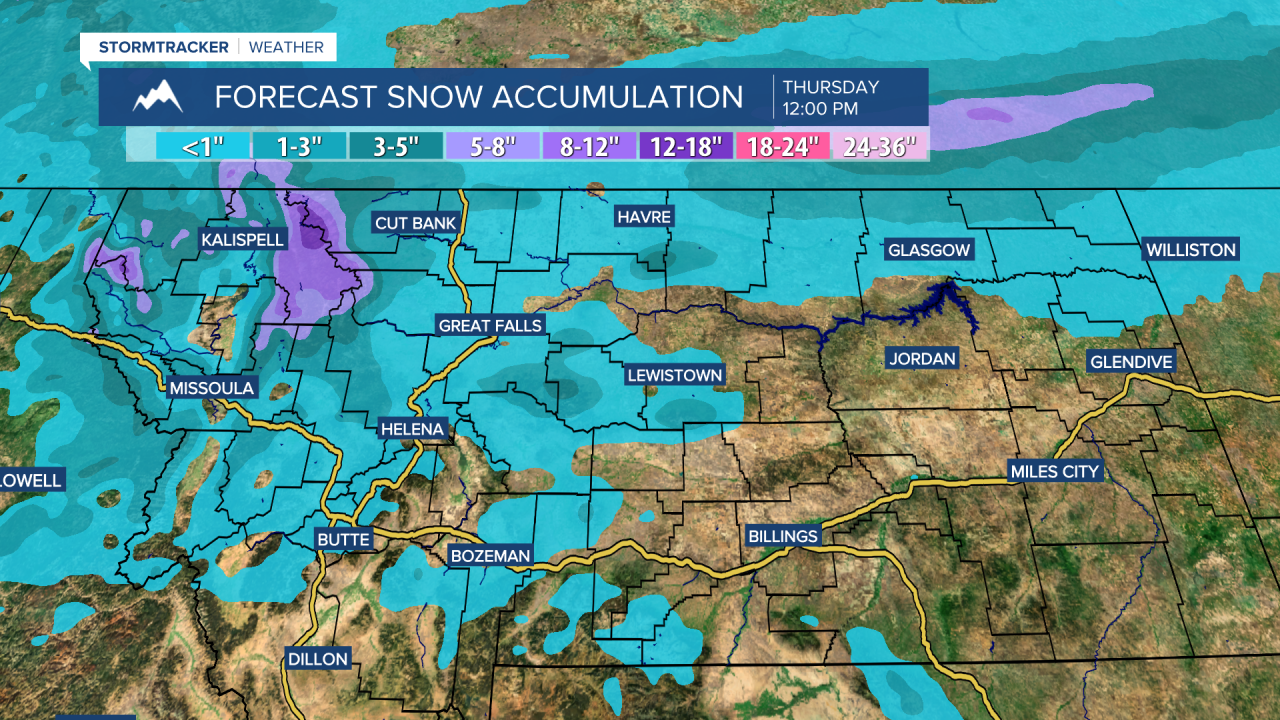
The highest snow amounts with this storm system are going to be in the Glacier National Park area, where 1 to 5 inches of snow accumulation is expected in the lower elevations, and 4 to 14+ inches of snow accumulation is expected at/above pass level. In the mountains in central Montana, up to 6 inches of snow accumulation is possible.
In the lower elevations in central and north-central Montana, a coating to 3 inches of snow accumulation is possible. The bigger impact from this storm system in the lower elevations is going to be the flash freeze. With precipitation starting out as rain, that will make paved surfaces wet. The temperatures are then going to quickly drop below freezing Wednesday night, which will cause this moisture to freeze. If you are going to be traveling anywhere Wednesday night or Thursday morning, please use extreme caution as roads are going to be slick.
It is also going to be breezy in some areas tomorrow and Thursday as sustained wind speeds are going to be between 10 and 25 mph. The temperatures are also going to cool down some between these two days as highs tomorrow are going to be in the 50s in most locations, and highs on Thursday are going to be in the mid to upper 30s and low to mid 40s.
We are then going to have really nice weather on Friday and Saturday as high pressure is going to be in control of our weather. On Friday, we are going to have lots of sunshine, and on Saturday, we are going to have partly cloudy to mostly sunny skies. We are also going to have pleasant temperatures on these two days as highs are going to be in the 50s and mid to upper 40s. There is also going to be a breeze around in some areas on these two days as sustained wind speeds are going to be between 10 and 20 mph.
On Sunday, we are going to have partly to mostly cloudy skies with a chance of rain and snow as a storm system impacts our area. It is also going to be windy on Sunday as sustained wind speeds are going to be between 15 and 30 mph, and wind gusts up to 50 mph are possible. Cooler temperatures are also expected on Sunday as highs are going to be in the mid to upper 40s and low 50s.
We are then going to have partly to mostly cloudy skies and mostly dry conditions on Monday and Tuesday. It is also going to be cooler on these two days than it is going to be this weekend as highs are going to be in the 40s in most locations. There is also going to be a breeze around in some areas on these two days as sustained wind speeds are going to be between 10 and 25 mph.