There are going to be scattered rain and snow showers around this evening and tonight as a disturbance passes through our area. In the lower elevations, mainly rain is expected, but some snow may mix in with this rain at times, and the rain may transition over to all snow in some lower elevation locations, especially in central and southern Montana. Snow accumulation with this disturbance will generally be at and above mountain pass level where up to 5 inches of snow accumulation is possible. In the lower elevations, a coating of snow accumulation is possible in locations that do see some snow. Also, please be careful when driving if you are going to be traveling over any of the mountain passes tonight or tomorrow morning.
Gusty winds will continue to be an issue this evening and tonight as wind gusts up to 40 mph are possible. The wind will gradually diminish from west to east though as the night goes on. It is also going to be chilly tonight as lows are going to be in the upper 20s and low to mid 30s in most locations.
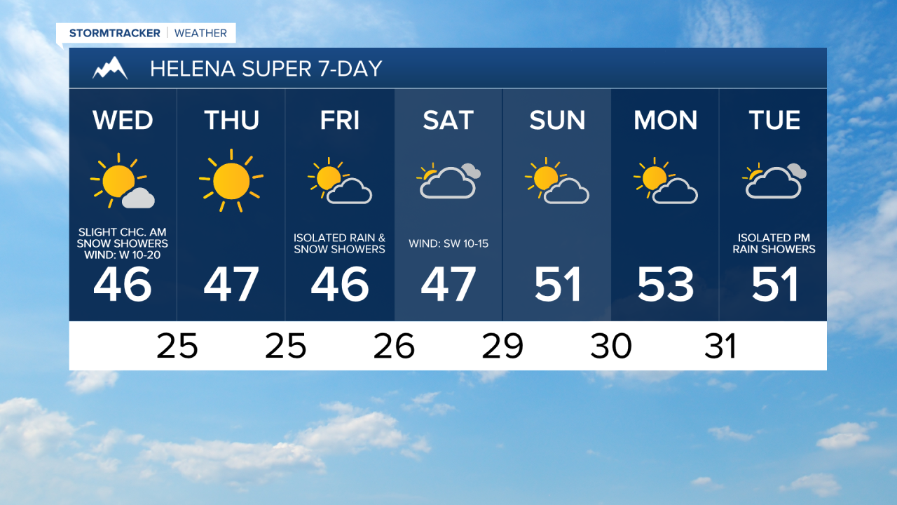
For tomorrow, we are going to have mostly to mainly sunny skies and seasonably cool temperatures as highs are going to be in the 40s and low 50s in most locations. There are also going to be some isolated snow showers around throughout the day tomorrow in the mountains and there are going to be a few isolated snow/rain showers around tomorrow evening along eastern portions of the Hi-Line. We are also going to have gusty winds around again tomorrow as sustained wind speeds are going to be between 10 and 25 mph, and wind gusts up to 40 mph are possible (up to 50 mph along the Rocky Mountain Front).
On Thursday, we are going to have mainly sunny skies, less wind (sustained wind speeds between 5 and 20 mph), and near to slightly above average temperatures as highs are going to be in the 40s and low 50s. We are then going to have partly to mostly cloudy skies on Friday with a few snow and rain showers around, generally in the mountains, as a disturbance passes through our area. Breezy conditions are also expected in some areas on Friday as sustained wind speeds are going to be between 10 and 25 mph. Also, highs on Friday are once again going to be in the 40s and low 50s.
For this weekend, we are going to have partly to mostly cloudy skies and mainly dry conditions on Saturday, and partly cloudy skies and dry conditions on Sunday. On Saturday, it is going to be windy as sustained wind speeds are going to be between 15 and 35 mph, and wind gusts up to 50 mph are going to be possible at times. Breezy conditions are then expected on Sunday as sustained wind speeds are going to be between 10 and 25 mph. The temperatures are also going to warm up some this weekend as highs are going to be in the mid to upper 40s and low 50s on Saturday, and the 50s and upper 40s on Sunday.
On Monday, we are going to have partly to mostly cloudy skies. We are then going to have mostly cloudy skies with a slight chance of PM rain and mountain snow showers on Tuesday as the next disturbance begins to approach our area. There is also going to be a bit of a breeze around on these two days as sustained wind speeds are going to be between 10 and 20 mph. We are also going to have above average temperatures on these two days as highs are going to be in the 50s on Monday, and the upper 40s and low to mid 50s on Tuesday.