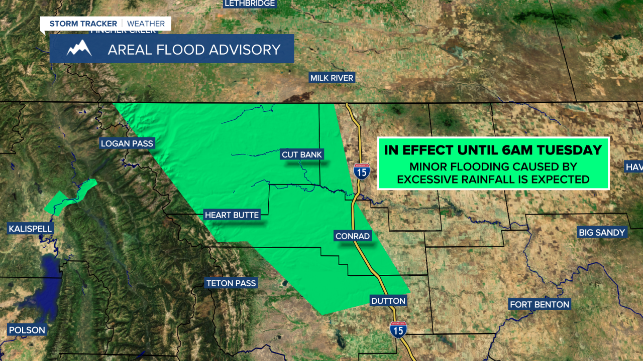
A FLOOD ADVISORY is in effect for portions of Glacier County, Pondera County, Teton County, and Toole County until 6am Tuesday. Minor flooding is expected in this area due to excessive rainfall.
A FLASH FLOOD WATCH is in effect for Broadwater County and Meagher County until 6am Tuesday. Due to excessive rainfall, flash flooding and debris flows are possible over the Deep Creek and Woods Creek burn scars.

There are going to continue to be areas of rain around tonight as an upper-level storm system slowly works its way eastward through our area. Some of this rain may be moderate to heavy at times and may cause some minor flooding. As the night goes on, this rain will gradually move eastward, and the rain will begin to taper off as we get closer to sunrise. Up to a half inch of additional rainfall is possible this evening and tonight, with localized higher amounts possible.
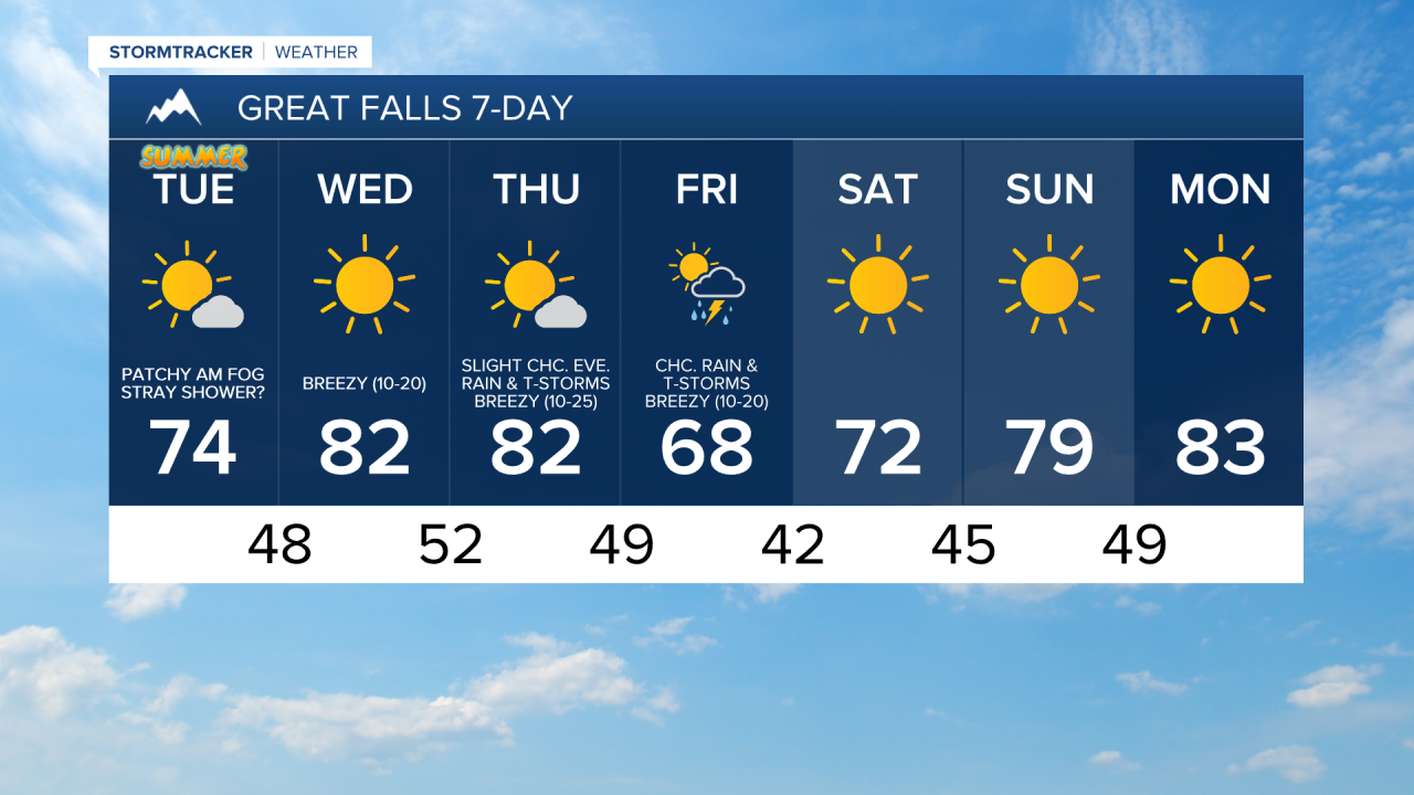
We are also going to have mostly cloudy to overcast skies early on tonight, with decreasing clouds during the second half of the night. Some patchy areas of fog may also develop later on tonight, especially in locations around and west of I-15. It is also going to be cool tonight as lows are going to be in the 40s and low to mid 50s. There is also going to be a bit of a breeze around tonight as sustained wind speeds are going to be between 5 and 20 mph.
For tomorrow, we are going to have mostly sunny skies with a few lingering showers around in eastern portions of north-central Montana during the morning, and a few stray showers and thunderstorms around during the afternoon and evening. A majority of locations are going to be dry tomorrow though. The temperatures are also going to be warmer tomorrow than they were today as highs are going to be in the upper 60s and low to mid 70s in most locations. It is also going to be a bit breezy tomorrow, especially in locations east of I-15, as sustained wind speeds are going to be between 10 and 20 mph, and wind gusts over 30 mph are going to be possible at times.
Warmer temperatures are then expected on Wednesday and Thursday as highs are going to be in the upper 70s and low to mid 80s in most locations. It is also going to be a bit breezy on Wednesday as sustained wind speeds are going to be between 10 and 20 mph, and it is going to be breezy on Thursday as sustained wind speeds are going to be between 10 and 25 mph. We are also going to have mainly sunny skies and dry conditions on Wednesday, and mostly sunny skies with a slight chance of PM rain showers and thunderstorms on Thursday.
On Friday, we are going to have a chance to see some rain showers and thunderstorms as a disturbance passes through our area. We are also going to have partly cloudy to mostly sunny skies and cooler temperatures on Friday as highs are going to be in the mid to upper 60s and low 70s. It is also going to be breezy on Friday as sustained wind speeds are going to be between 10 and 20 mph.
We are then going to have fantastic weather this weekend and on Monday as we are going to have lots of sunshine, mainly dry conditions, and not much wind as sustained wind speeds are generally going to be between 5 and 15 mph. The temperatures are also going to warm up some over these three days as highs are going to be in the upper 60s and low to mid 70s on Saturday; the mid to upper 70s and low 80s on Sunday; and the low to mid 80s on Monday.