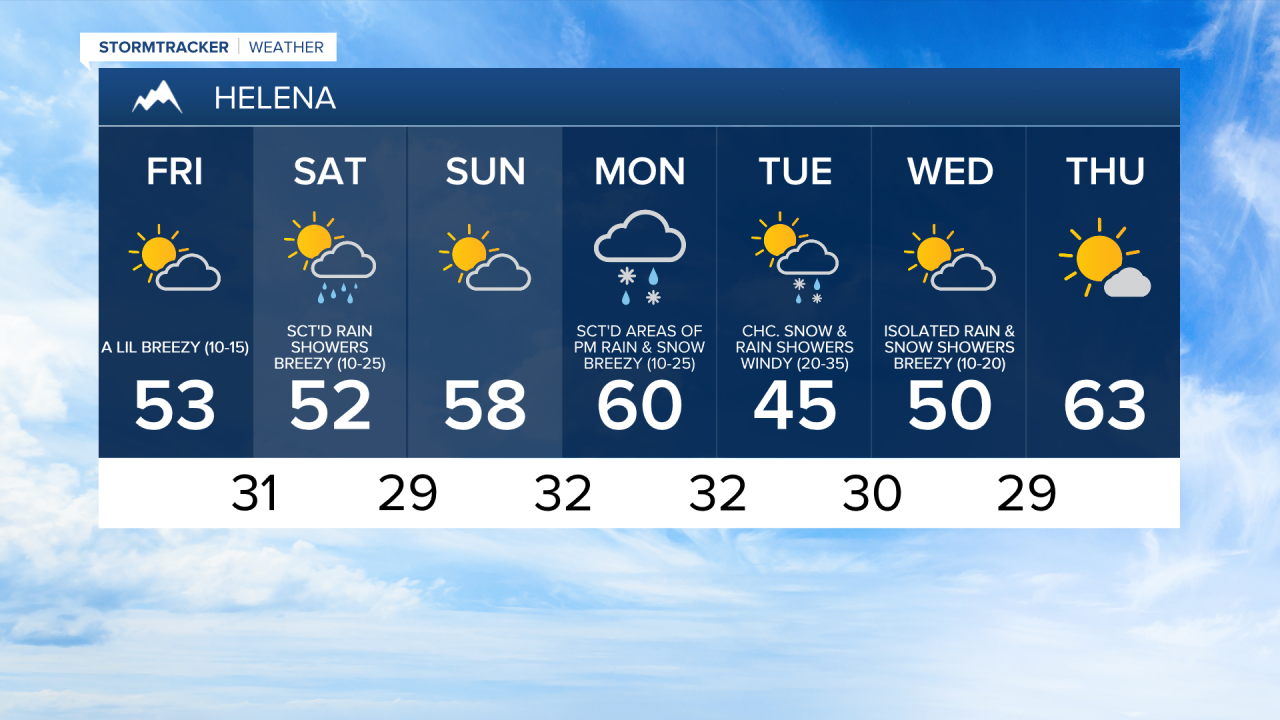
There are going to be a few scattered rain, graupel, and snow showers around tonight, generally before midnight, as a disturbance continues to work its way through our area. We are also going to have diminishing wind this evening, and just a little bit of a breeze around tonight as sustained wind speeds are going to be between 5 and 15 mph. It is also going to be chilly tonight as lows are going to be in the mid to upper 20s and low 30s. Partly cloudy skies are also expected tonight.
For tomorrow, we are going to have partly cloudy skies with a few rain, graupel, and snow showers around, generally in locations east of I-15. We are also going to have seasonable temperatures tomorrow as highs are going to be in the mid to upper 40s and low to mid 50s. There is also going to be a bit of a breeze around tomorrow, especially during the afternoon and evening, as sustained wind speeds are going to be between 10 and 20 mph.
There are then going to be some scattered rain and snow showers around on Saturday, generally during the afternoon and evening, as another disturbance passes through our area. We are also going to have gusty winds around on Saturday, especially during the afternoon and evening, as sustained wind speeds are going to be between 10 and 30 mph, and wind gusts up to 40 mph are going to be possible at times. Seasonable temperatures are also expected on Saturday as highs are going to be in the upper 40s and low to mid 50s.
We are then going to have partly cloudy skies and mostly dry conditions on Sunday. It is also going to be mild on Sunday as highs are going to be in the mid to upper 50s and low 60s. There is also going to be a little bit of a breeze around on Sunday as sustained wind speeds are going to be between 5 and 20 mph.
On Monday, we are going to have mostly cloudy skies with some isolated lower elevation rain and higher elevation snow/rain showers around in north-central Montana. In south-central Montana, we are going to have mostly cloudy skies on Monday with scattered areas of rain and snow around during the afternoon and evening as a cold front begins to approach our area. It is also going to be mild and windy on Monday as highs are going to be in the upper 50s and low to mid 60s, and sustained wind speeds are going to be between 15 and 30 mph.
There are then going to be some scattered rain and snow showers around on Tuesday as the cold front leaves our area and as another disturbance begins to approach our area. It is also going to be a lot cooler on Tuesday than it is going to be on Monday as highs are only going to be in the 40s. Strong winds are also expected on Tuesday as sustained wind speeds are going to be between 20 and 40 mph, and wind gusts over 60 mph are going to be possible at times.
We are then going to have a chance to see some more rain and snow showers on Wednesday as a disturbance works its way through our area. We are also going to have partly cloudy skies and seasonable temperatures on Wednesday as highs are going to be on either side of 50 degrees. Breezy conditions are also expected on Wednesday as sustained wind speeds are going to be between 10 and 25 mph.
Mostly sunny skies and dry conditions are then expected on Thursday as high pressure is going to build into our area. It is also going to be a lot warmer on Thursday than it is going to be on Wednesday as highs are going to be in the low to mid 60s.