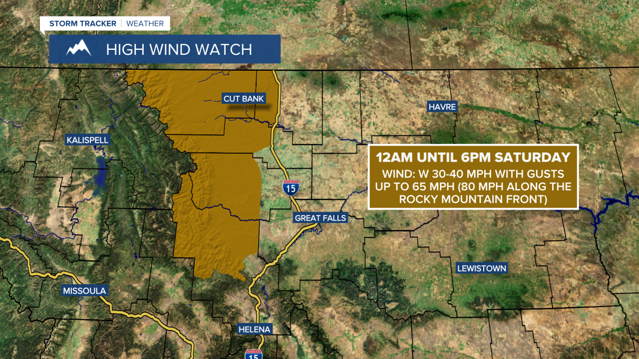
A HIGH WIND WATCH is in effect for Glacier County, northern Lewis and Clark County, western/central Pondera County, western Teton County, and western Toole County from 12am until 6pm Saturday. Sustained wind speeds are going to be between 30 and 40 mph, and wind gusts up to 65 mph (80 mph along the Rocky Mountain Front) are going to be possible at times.
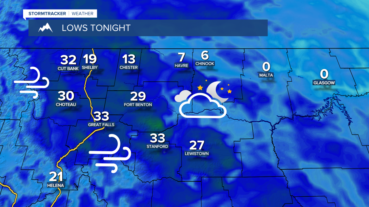
We are going to have partly to mostly cloudy skies and mainly dry conditions tonight. We are also going to have a wide range of temperatures tonight as lows are going to range from around zero degrees to the mid 30s, with the coldest temperatures along the central and eastern half of the Hi-Line. It is also going to be breezy in some areas tonight as sustained wind speeds are going to be between 10 and 25 mph, and wind gusts over 40 mph are going to be possible at times.
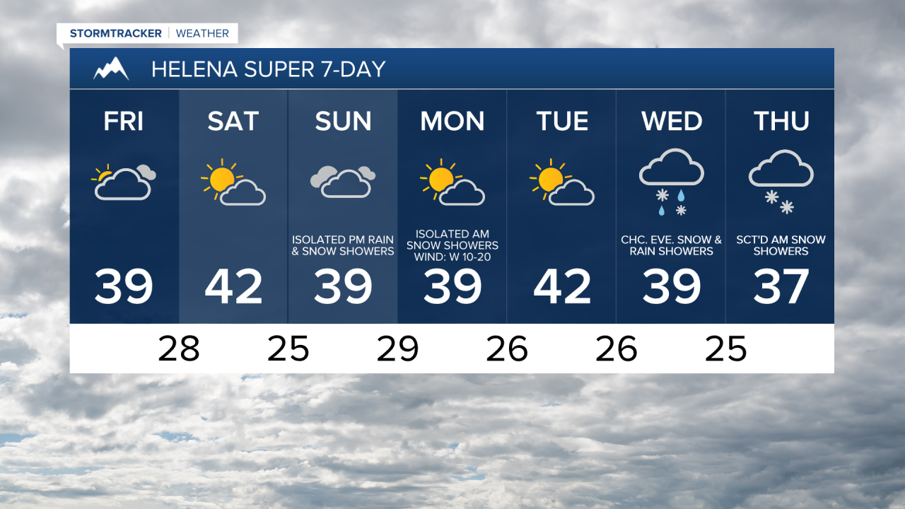
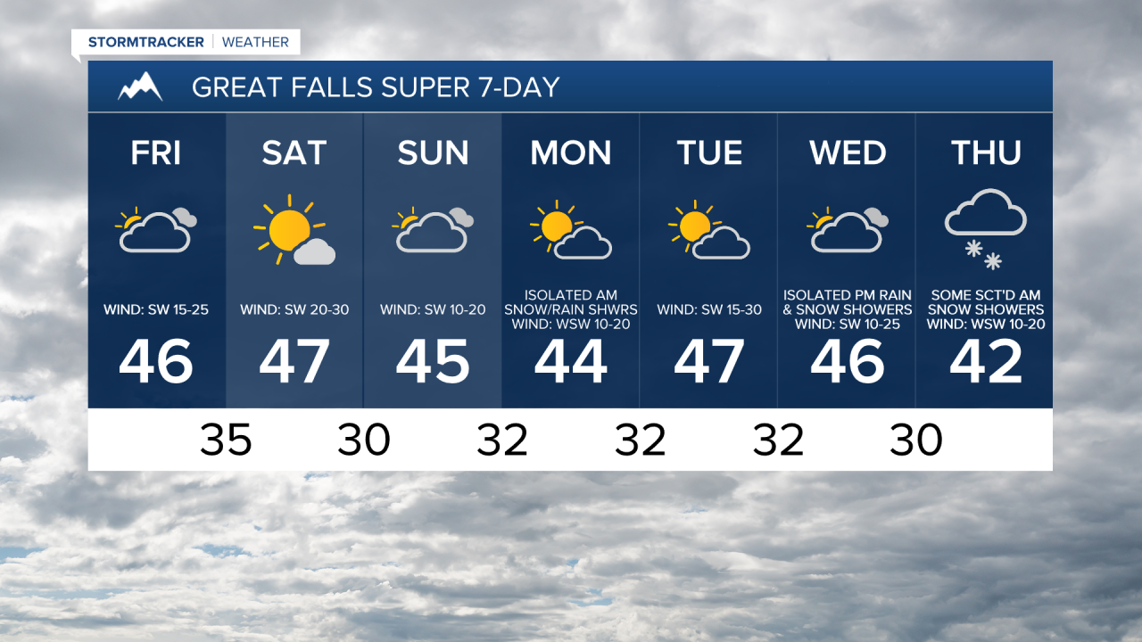
For tomorrow, we are going to have partly to mostly cloudy skies, with more sunshine around the further east of I-15 you go. We are also going to have gusty winds around tomorrow in a lot of central and north-central Montana as sustained wind speeds are going to be between 10 and 30 mph, and wind gusts over 40 mph are going to be possible at times. It is also going to feel nice outside tomorrow as highs are going to be in the 30s and 40s in most locations.
From tomorrow evening through Saturday morning, there are going to be some isolated snow and rain showers around east of the Divide, generally in the higher elevations, as a disturbance passes through our area. We are also going to have mostly cloudy skies tomorrow night and partly cloudy to mostly sunny skies on Saturday. It is also going to be cool tomorrow night as lows are going to be in the 20s and 30s, and it is going to be mild on Saturday as highs are going to be in the 40s and mid to upper 30s.
We are also going to have increasing wind tomorrow night, with widespread windy conditions around later on tomorrow night and during the day on Saturday. Along the Rocky Mountain Front, sustained wind speeds are going to be between 25 and 45 mph, and wind gusts up to 80 mph are going to be possible at times. East of the Rocky Mountain Front, sustained wind speeds are going to be between 15 and 35 mph, and wind gusts over 50 mph are going to be possible at times.
On Sunday, we are going to have mostly cloudy skies with a few isolated rain and snow showers around, generally in the mountains around the Helena area, as another disturbance begins to approach our area. There are then going to be a few widely scattered snow and rain showers around Sunday night and Monday morning, especially in the mountains, as this disturbance passes through our area. We are also going to have partly cloudy skies on Monday.
It is also going to be breezy on Sunday and Monday as sustained wind speeds are going to be between 10 and 25 mph. We are also going to continue to have above average temperatures on these two days as highs are going to be in the mid to upper 30s and low to mid 40s in most locations.
We are then going to have partly cloudy skies and mainly dry conditions on Tuesday. It is also going to be windy on Tuesday as sustained wind speeds are going to be between 15 and 35 mph, and wind gusts over 50 mph are going to be possible at times. Mild temperatures are also expected on Tuesday as highs are going to be in the 40s in a lot of locations.
There are then going to be some scattered snow and rain showers around on Wednesday and Thursday, generally from Wednesday evening through Thursday morning, as another disturbance passes through our area. The temperatures are also going to cool down a little bit over these two days as highs are going to be in the 40s and mid to upper 30s on Wednesday, and the mid to upper 30s and low to mid 40s on Thursday. It is also going to be breezy on Wednesday as sustained wind speeds are going to be between 10 and 25 mph.